
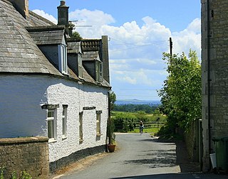
Kelmscott is a village and civil parish on the River Thames in West Oxfordshire, about 2 miles (3 km) east of Lechlade in neighbouring Gloucestershire. Since 2001 it has absorbed Little Faringdon, which had been a separate civil parish. The 2011 Census recorded the merged parish's population as 198.

Sherston is a village and civil parish about 5 miles (8 km) west of Malmesbury in Wiltshire, England. The parish is bounded to the north by the county boundary with Gloucestershire, and to the southeast by the Fosse Way, a Roman road. The parish includes the hamlets of Easton Town, immediately east of Sherston; Pinkney, further east along the Malmesbury road; and Willesley, to the north.

Badminton is a village and civil parish in South Gloucestershire, England. The only settlement in the parish is Badminton village, sometimes called Great Badminton to distinguish it from the hamlet of Little Badminton, about one mile to the north in Hawkesbury parish. The large country house called Badminton House is close to the north end of the village, and its surrounding deer park lies to the north and west.

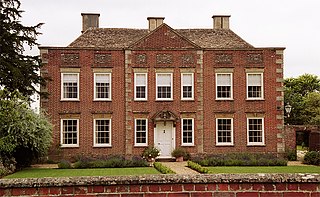
Badminton House is a large country house and Grade I Listed Building in Badminton, Gloucestershire, England, which has been the principal seat of the Dukes of Beaufort since the late 17th century. The house, which has given its name to the sport of badminton, is set among 52,000 acres (21,000 ha) of land. The gardens and park surrounding the house are listed at Grade I on the Register of Historic Parks and Gardens.

Hawkesbury is a hamlet and civil parish in South Gloucestershire, England. The hamlet, consisting of a few cottages around a triangular green, lies west of Hawkesbury Upton, off the A46 road.

Doynton is a village in South Gloucestershire, England. The population of this village taken at the 2011 census was 320.
Atworth is a village and civil parish in west Wiltshire, England. The village is on the A365 road between Melksham and Box, about 2.5 miles (4 km) northwest of Melksham and 4 miles (6 km) northeast of Bradford on Avon. The hamlet of Purlpit lies east of Atworth village, and in the south of the parish are the small village of Great Chalfield and the hamlet of Little Chalfield.

Wylye is a village and civil parish on the River Wylye in Wiltshire, England. The village is about 9+1⁄2 miles (15 km) northwest of Salisbury and a similar distance southeast of Warminster.

Compton Martin is a small village and civil parish within the Chew Valley in Somerset and in the Bath and North East Somerset unitary authority in England. The parish has a population of 508. It lies between Chew Valley Lake and Blagdon Lake, north of the Mendip Hills, approximately 10 miles (16 km) south of Bristol on the A368 road Weston-super-Mare to Bath.

Leigh Delamere is a small village in the civil parish of Grittleton in the English county of Wiltshire, about 4 miles (6 km) northwest of the town of Chippenham. The M4 motorway passes some 250 metres to the south, and the motorway's Leigh Delamere services lie to the east of the village.

Stanton Harcourt is a village and civil parish in Oxfordshire about 4 miles (6.4 km) southeast of Witney and about 6 miles (10 km) west of Oxford. The parish includes the hamlet of Sutton, 1⁄2 mile (800 m) north of the village. The 2011 Census recorded the parish's population as 960.

Cornwell is a small village and civil parish about 2.5 miles (4 km) west of Chipping Norton in the West Oxfordshire district of Oxfordshire, near the county border with Gloucestershire. The 2001 Census recorded the parish's population as 66.

Great Tew is an English village and civil parish in Oxfordshire, about 5 miles (8 km) north-east of Chipping Norton and 8 miles (13 km) south-west of Banbury. The 2011 census gave a parish population of 156. This qualifies it for an annual parish meeting, not a monthly parish council. The village has largely belonged since the 1980s to the Johnston family, as the Great Tew Estate, with renovations and improvements.

Semley is a village and former civil parish, now in the parish of Sedgehill and Semley, in Wiltshire, England, about 3 miles (4.8 km) north-east of Shaftesbury in neighbouring Dorset. The hamlet of Sem Hill lies about a quarter of a mile west of the village. In 1961 the parish had a population of 477.

Loversall is a village and civil parish in the City of Doncaster in South Yorkshire, England. It has a population of 128, increasing to 156 at the 2011 Census.

Westwell is a small village and civil parish about 2 miles (3 km) southwest of the market town of Burford in Oxfordshire. It is the westernmost village in the county, close to the border with Gloucestershire.

Inglesham is a small village and civil parish in the Borough of Swindon, Wiltshire, England, notable for the Grade-I listed St John the Baptist Church. The village is just off the A361 road about 1 mile (1.6 km) south-west of Lechlade in Gloucestershire. Most of the population lives in the hamlet of Upper Inglesham, which is on the main road about 1.3 miles (2 km) south of the village.
Tockenham is a village and civil parish in north Wiltshire, England. The village is about 1.2 miles (1.9 km) east of Lyneham and 3 miles (5 km) southwest of the town of Royal Wootton Bassett. The parish includes the hamlet of Tockenham Wick.

Sopworth is a small village and civil parish in northwest Wiltshire, England, on the county's border with Gloucestershire. The village lies about 1.7 miles (2.7 km) west of Sherston and 6.5 miles (10 km) west of Malmesbury. The parish is within the Cotswolds Area of Outstanding Natural Beauty.

Temple Guiting is a village and civil parish in the Cotswolds, in Gloucestershire, England. The civil parish includes the smaller settlements of Barton, Farmcote, Ford and Kineton. In 2011 the parish had a population of 463.
