
Richmond County is a county located on the central southern border of the U.S. state of North Carolina. As of the 2020 Census, the population was 42,946. Its county seat is Rockingham. Richmond County comprises the Rockingham, NC Micropolitan Statistical Area. The Hamlet-Rockingham metropolitan area has a population of 22,579.
Over is a village in the civil parish of Almondsbury in South Gloucestershire, England 6 miles (10 km) north of Bristol. It lies on the B4055, a road that parallels the M5 from Junction 17 to 16. The road, known locally as Over Lane, abuts to the east a ridge which overlooks the Severn floodplain, dominated by Bristol Golf Club or Course. According to local legends, a ghost of an old woman haunts this place every New Year's Eve.
Coombe is a hamlet in the parish of Ellesborough in the English county of Buckinghamshire, situated between Coombe Hill and Chequers, the official country residence of the Prime Minister of the United Kingdom. At the 2011 Census the population of the hamlet was included in the civil parish of Wendover.

Coalpit Heath is a small village in the parish of Westerleigh, South Gloucestershire, England, south of Yate and east of Frampton Cotterell in South Gloucestershire.

Skidby is a small village and civil parish in Yorkshire Wolds of the East Riding of Yorkshire, England. It is situated about 6 miles (10 km) north-west of Hull city centre, 2.2 miles (3.5 km) west of Cottingham and 5 miles (8 km) south of Beverley.
Ash-cum-Ridley is a civil parish in the Sevenoaks district of Kent, England. According to the 2001 census the parish had a population of 7,070, reducing to 6,641 at the 2011 Census.

Portballintrae is a small seaside village in County Antrim, Northern Ireland. It is four miles east of Portrush and two miles west of the Giant's Causeway. In the 2001 Census it had a population of 734 people, a decline of 10% compared to 1991. It lies within the Causeway Coast and Glens District Council area.
Charlton was the name of a small village or large hamlet in Gloucestershire, England with a Bethel Chapel and Sunday School. It was demolished in the late 1940s. Its site is occupied by part of the derelict runway and safety margins of the former Bristol Filton Airport. The village was located between Filton and what is today the Cribbs Causeway out-of-town commercial and retail area immediately north of Bristol. To the north of the village lay fields and Over Court Deer Park. which is today Bristol Golf Club.

The Home Park, previously known as the Little Park, is a private 655-acre (265 ha) Royal park, administered by the Crown Estate. It lies on the eastern side of Windsor Castle in the town and former civil parish of Windsor in the English county of Berkshire. To its south is Windsor Great Park.

Codrington is a settlement in South Gloucestershire, England. It is located near Junction 18 of the M4 motorway south of Wapley and Yate.
Box Grove(Census Tract 5350400.01) is an original community in Markham, Ontario.
Paddockwood is a village in the Canadian province of Saskatchewan within the Rural Municipality of Paddockwood No. 520 and Census Division No. 15. It was named after the town Paddock Wood in Kent, England.
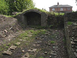
Ram Hill Colliery, was a privately owned colliery in the Coalpit Heath area north-east of Bristol, England. It operated between about 1825 and 1865.

Crazies Hill is a hamlet in the English county of Berkshire. It adjoins the hamlet of Cockpole Green. For local government purposes, the village is within the civil parish of Wargrave, which in turn is within the unitary authority of Wokingham. Crazies Hill Church of England Primary School is located in the village. About 0.6 miles (1 km) on the road to Wargrave is Hennerton Golf Club. The Village Hall was originally built to serve also as a Mission church and still contains the paraphernalia of an altar etc. behind folding doors.
Blackstone is a hamlet in the civil parish of Woodmancote and the Horsham district of West Sussex, England. Blackstone is significant for its listed 17th- and 18th-century houses and cottages.
Good Spirit Acres is a hamlet in the Canadian province of Saskatchewan. It is located 2 km south of Good Spirit Lake and Good Spirit Lake Provincial Park in the RM of Good Lake No. 274.

Henfield is a hamlet in South Gloucestershire, England between Coalpit Heath and Westerleigh, adjoining the hamlet of Ram Hill immediately to the north.

Ram Hill is a hamlet in South Gloucestershire, England. It is located between Coalpit Heath and Westerleigh and adjoins the hamlet of Henfield immediately to the south. In the Mudge Map 1815, Ram Hill was known as Nutridge Hill, and was linked to Westerleigh by Broad Lane and to Mays Hill by Frog Lane.

St Brides Major is a community on the western edge of the Vale of Glamorgan, South Wales. Its largest settlement is the village of St Brides Major, and also includes the villages of Ogmore-by-Sea and Southerndown, and the hamlets of Ogmore Village, Castle-upon-Alun, Heol-y-Mynydd, Norton and Pont-yr-Brown It is notable for coastal geology and scenery, limestone downlands and fossilised primitive mammals, sea cliffs and beaches, two Iron Age hillforts, three medieval castle sites,, two stepping stone river crossings and a clapper bridge. Three long distance paths cross the community. It is the western limit of the Vale of Glamorgan Heritage Coast, and has a visitor centre and tourist facilities.
