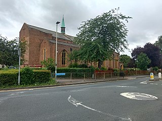
Thornbury is a market town and civil parish in the South Gloucestershire unitary authority area of England, about 12 mi (19 km) north of Bristol. It had a population of 12,063 at the 2011 census. The population has risen to 14,496 in the 2021 census. Thornbury is a Britain in Bloom award-winning town, with its own competition: Thornbury in Bloom. The earliest documentary evidence of a village at "Thornbyrig" dates from the end of the 9th century. The Domesday Book of 1086 noted a manor of "Turneberie" belonging to William the Conqueror’s consort, Matilda of Flanders, with 104 residents.

Wotton-under-Edge is a market town and civil parish in the Stroud district of Gloucestershire, England. Near the southern fringe of the Cotswolds, the Cotswold Way long-distance footpath passes through the town.

Charfield is a village and civil parish in Gloucestershire, England, south-west of Wotton-under-Edge near the Little Avon River and the villages of Falfield and Cromhall. The parish includes the hamlet of Churchend.

Wickwar is a village and civil parish in Gloucestershire, England, located between Yate and Charfield. At the 2001 census, the parish had a population of 1,943.
Oldbury-on-Severn is a small village near the mouth of the River Severn in the South Gloucestershire district of the county of Gloucestershire in the west of England. The parish, which includes the village of Cowhill had a population at the 2011 census of 780. It is home to the nearby Oldbury nuclear power station, a Magnox power station which opened in 1967 and ceased operation on 29 February 2012.
Falfield is a village, located near the northern border of the South Gloucestershire district of Gloucestershire, England on the southern edge of the Berkeley Vale, to the east of the River Severn and just falling into the boundary of the Cotswolds. It is the last parish on the northern boundary of South Gloucestershire. The area has a Wotton-under-Edge (GL12) post code and so is often incorrectly listed as being in the Stroud district of Gloucestershire. Falfield is one of the longest villages in England, alongside local village Cromhall.

Coalpit Heath is a small village in the civil parish of Westerleigh and Coalpit Heath, in the South Gloucestershire district, in the ceremonial county of Gloucestershire, England, south of Yate and east of Frampton Cotterell.

Hardwicke is a large village on the A38 road 7 km south of the city of Gloucester, Gloucestershire, England. Despite its proximity to Gloucester, the village comes under Stroud Council. The population of the village taken at the United Kingdom Census 2011 was 3,901.
Uley is a village and civil parish in the county of Gloucestershire, England. The parish includes the hamlets of Elcombe and Shadwell and Bencombe, all to the south of the village of Uley, and the hamlet of Crawley to the north. The village is situated in a wooded valley in the Cotswold escarpment, on the B4066 road between Dursley and Stroud.

Charlton Kings is a contiguous village adjoining Cheltenham in Gloucestershire, England. The area constitutes a civil parish of 10,396 residents (2011).

Cromhall is a village in South Gloucestershire, England. It is located between Bagstone and Charfield on the B4058, and also borders Leyhill. The parish population taken at the 2011 census was 1,231.

Doynton is a village in South Gloucestershire, England. The population of this village taken at the 2011 census was 320.

Slad is a village in Gloucestershire, England, in the Slad Valley about 2 miles (3 km) from Stroud on the B4070 road from Stroud to Birdlip.

Nympsfield is a village and civil parish in the English county of Gloucestershire. It is located around four miles south-west of the town of Stroud. As well as Nympsfield village, the parish contains the hamlet of Cockadilly. The population taken at the 2011 census was 382.

Drybrook is a village and civil parish in the Forest of Dean in west Gloucestershire, England.

Shenington is a village and former civil parish, now in the parish of Shenington with Alkerton, in the Cherwell district, in the county of Oxfordshire, England. It is about 5 miles (8 km) west of Banbury, it was an exclave of Gloucestershire until the Counties Act 1844 transferred it to Oxfordshire. Shenington is on Oxfordshire's boundary with Warwickshire. Shenington was an ancient parish of 1,628 acres (659 ha). In 1961 the parish had a population of 232. On 1 April 1970 the parish was abolished and merged with Alkerton to form "Shenington with Alkerton".
Charles Edwin Ponting, F.S.A., (1850–1932) was a Gothic Revival architect who practised in Marlborough, Wiltshire.

Holy Trinity Church is a Grade II listed Church of England parish church in Longlevens, Gloucester. It was designed by Harold Stratton Davis and built in 1933–1934 in a fifteenth-century perpendicular Gothic style. It includes German and Dutch stained glass that was transferred from the Church of St Luke, High Orchard, Gloucester, after that church was demolished in 1934.


