Hill, Gloucestershire

Last updated

Hill (Parish)
Hill (Glos) St Michael's Church - geograph.org.uk - 67873.jpg
St Michael's Church, Hill
Gloucestershire UK location map.svg
Red pog.svg
Hill (Parish)
Location within Gloucestershire
Population117 (2011 Census)
OS grid reference ST 64537 95037
Civil parish
  • Hill
District
  • South Gloucestershire
Shire county
Region
Country England
Sovereign state United Kingdom
Post town Berkeley
Postcode district GL13
Dialling code 01454
Police Avon and Somerset
Fire Avon
Ambulance South Western
List of places
UK
England
Gloucestershire
51°39′11″N2°30′50″W / 51.653°N 2.514°W / 51.653; -2.514

Hill is a village and civil parish in South Gloucestershire, England, midway between the towns of Thornbury in South Gloucestershire and Berkeley in Gloucestershire. The parish stretches from the banks of the River Severn to an outcrop of the Cotswolds escarpment. At the 2001 census, it had a population of 114. [1] Hill is approximately 5 miles from the M5 motorway which links to Gloucester, Cheltenham and Bristol.

Contents

History

In the Domesday Book, Hill is recorded as Hilla, then later between the years of 1250 to 1455 is referred to frequently as Hulla. It was not until after 1773 until it was more commonly known as Hill. [2]

In 1870-72, John Marius Wilson's Imperial Gazetteer of England and Wales described Hill like this:

HILL, a parish in Thornbury district, Gloucester; adjacent to the river Severn, 4 miles N of Thornbury, and 5½ W by S of Dursley Junction r. station. Posttown, Berkeley. Acres, 2, 476; of which 510 are water. Real property, £4, 146. Pop., 216. Houses, 44. The property is divided among a few. The manor belongs to Herbert Jenner, Esq. Hill Court is an ancient mansion, supposed to occupy the site of a monastery of the 12th century. The living is a donative in the diocese of Gloucester and Bristol. Value, £250.* Patron, Herbert Jenner, Esq. The church is ancient but good; and has a tower and spire. [3]
Total population of Hill civil parish, Gloucestershire, as reported by the census of population from 1801-2011 Hill population time series 1801-2011.jpg
Total population of Hill civil parish, Gloucestershire, as reported by the census of population from 1801-2011

Industry and social structure

Census data dating back to 1831 shows that the principal industry in Hill has been agriculture, accounting for approximately 75 per cent of the workforce in 1831. [4]

One product still currently farmed in Hill is rapeseed which is commonly grown for the oil-rich seeds used in the production of vegetable oil. The continuing existence of four working farms in Hill today indicates that agriculture is still of importance to the local economy. Historically the second-largest category of employment has been as labourers; [5] this proportion, however, decreased throughout the end of the twentieth century to make way for an increase in professional employment. The employment in agriculture historically was male-dominated; census data from 1881 indicates that 80 per cent of the employed women in Hill were employed in domestic service. [6] According to the 2011 census, the largest proportions of employment in Hill were in the areas of manufacturing, education and retail. [7]

1881 Occupations of Males and Females in Hill, Gloucestershire from 1881 Census data 1881 Occupational orders of Males and Females in Hill, Gloucestershire.jpg
1881 Occupations of Males and Females in Hill, Gloucestershire from 1881 Census data

Population history

The total number of households in Hill today[ when? ] is similar to the number of households in Hill in 1901. The 1901 census showed there being a total of 40 households, [8] whereas the 2011 census showed there to be a total of 42 households, the majority of which were made up of two adults with one or two children. [9]

The Manor of Hill

The Manor of Hill, known as Hill Court, was included in a grant of the Barony of Berkeley, bestowed upon Robert Fitzharding by Henry II of England after his ascension to the throne in 1154. The manor was transferred down successive generations of the Berkeley family until it came into the possession of Robert Poyntz of nearby Iron Acton in 1418. The Poyntz family gave up the manor at the beginning of the 17th century, Richard Fust subsequently assuming the lordship in 1609. Built in 1863, the present Hill Court, home of the Jenner-Fust family, replaced an earlier building. [10]

The Catgrove Murder

On 18 January 1816, a group of sixteen poachers were encountered by a party of gamekeepers belonging to Colonel Berkeley and Lord Ducie at Catgrove, a wooded area in the parish of Hill. Some of the poachers were in possession of firearms, which led to an assistant gamekeeper named William Ingram, a member of Berkeley's contingent, to be shot dead. The poachers fled the scene. Most, but not all, were subsequently apprehended and taken into custody. In total 11 men stood trial, all of whom were found guilty, leading to two of the guilty party being executed the following day and the remaining convicts faced transportation to Australia. [11]

Geography

According to the Ordnance Survey of 1880, the total area of the civil parish of Hill was 2270.7 acres; this included 217.95 acres of foreshore of the tidal River Severn. The boundary of the parish was the centre of the river’s channel at low tide. [12] Over 1500 acres of Hill are meadow and pasture lands, approximately 210 acres of arable land and 130 acres of woodland. [13] Ordnance Survey maps show Hill to have four small areas of woodland, in order of descending size these areas are; Catgrove, Fishpond Wood, Church-hill Wood and Ash Grove. Along with these Woodland areas, Ordnance Survey maps also show a number of small streams running through the centre and towards the west of the parish. [14] The British History Online’s website contains an extract from A Topographical Dictionary of England (1848) by Samuel Lewis, which described Hill’s geography as:

The surface of the western portion, extending to the river, which is here more than two miles wide, is a complete level, clothed with luxuriant herbage, and studded with numerous groups of stately trees; the eastern portion is finely undulated, rising into eminences of considerable elevation, two of which, immediately above the mansion of Hill Court, command extensive prospects. The soil is chiefly a loam, producing abundant crops. [15]
20th Century Ordnance Survey Map of Hill, Gloucestershire 20th Century Ordnance Survey Map of Hill, Gloucestershire.JPG
20th Century Ordnance Survey Map of Hill, Gloucestershire

St Michael the Archangel's Church

Hill is home to one parish church, St Michael the Archangel's Church. St Michael's belongs to the Church of England and is in the archdeaconry and Diocese of Gloucester. [16] The church was originally constructed in the 13th century and is a Grade II* listed building. The church has undergone restorations; the nave was rebuilt in 1759 and the mortuary chapel was stored in the early 18th century, both by Francis Fust. The chancel was restored in 1870 by Ewan Christian, followed by the rebuilding of the porch and addition of buttresses in 1909 by William Weir and Temple Moore. [17]

Related Research Articles

<span class="mw-page-title-main">Gloucestershire</span> County of England

Gloucestershire is a ceremonial county in South West England. It borders Herefordshire to the north-west, Worcestershire to the north, Warwickshire to the north-east, Oxfordshire to the east, Wiltshire to the south, Bristol and Somerset to the south-west, and the Welsh county of Monmouthshire to the west. The city of Gloucester is the largest settlement and the county town.

<span class="mw-page-title-main">Thornbury, Gloucestershire</span> Market town in Gloucestershire, England

Thornbury is a market town and civil parish in the South Gloucestershire unitary authority area of England, about 12 mi (19 km) north of Bristol. It had a population of 12,063 at the 2011 census. The population has risen to 14,496 in the 2021 census. Thornbury is a Britain in Bloom award-winning town, with its own competition: Thornbury in Bloom. The earliest documentary evidence of a village at "Thornbyrig" dates from the end of the 9th century. The Domesday Book of 1086 noted a manor of "Turneberie" belonging to William the Conqueror’s consort, Matilda of Flanders, with 104 residents.

<span class="mw-page-title-main">South Gloucestershire</span> District in England

South Gloucestershire is a unitary authority area in the ceremonial county of Gloucestershire, South West England. Towns in the area include Yate, Chipping Sodbury, Thornbury, Filton, Patchway and Bradley Stoke. The southern part of its area falls within the Greater Bristol urban area surrounding the city of Bristol.

<span class="mw-page-title-main">Berkeley, Gloucestershire</span> Town in Gloucestershire, England

Berkeley is a market town and civil parish in the Stroud District in Gloucestershire, England. It lies in the Vale of Berkeley between the east bank of the River Severn and the M5 motorway. The town is noted for Berkeley Castle, where the imprisoned King Edward II is believed to have been murdered, as well as the birthplace of the physician Edward Jenner, pioneer of the smallpox vaccine, the world's first vaccine. The parish includes the village of Berkeley Heath.

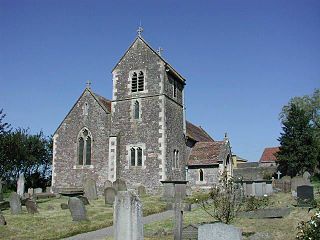
Falfield is a village, located near the northern border of the South Gloucestershire district of Gloucestershire, England on the southern edge of the Berkeley Vale, to the east of the River Severn and just falling into the boundary of the Cotswolds. It is the last parish on the northern boundary of South Gloucestershire. The area has a Wotton-under-Edge (GL12) post code and so is often incorrectly listed as being in the Stroud district of Gloucestershire. Falfield is one of the longest villages in England, alongside local village Cromhall.

<span class="mw-page-title-main">Rockhampton, Gloucestershire</span> Human settlement in England

Rockhampton is a village and civil parish in the English county of Gloucestershire, situated in the unitary district of South Gloucestershire. It is located 2.8 miles (4.5 km) northeast of Thornbury, 18.6 miles (29.9 km) north of Bristol and is approximately 4 miles (6.4 km) east of the River Severn. It had a population of 166 people according to the 2011 census.

<span class="mw-page-title-main">Churchdown</span> Human settlement in England

Churchdown is a large village in Gloucestershire, England, situated between Gloucester and Cheltenham in the south of the Tewkesbury Borough.

<span class="mw-page-title-main">Acton Turville</span> Human settlement in England

Acton Turville is a parish in the Cotswold Edge ward within South Gloucestershire, England. It lies 17 miles (27 km) east-northeast of Bristol and 93 miles (150 km) due west of London, with the M4 south of the parish. Acton Turville consists of a cluster of households across 1,009 acres, with a total population of 370 people. Acton Turville is also listed as "Achetone" in the Domesday Book.

<span class="mw-page-title-main">West Littleton</span> Human settlement in England

West Littleton is a village and former civil parish, now in the parish of Tormarton, in the South Gloucestershire district, in the ceremonial county of Gloucestershire, England. It is located between the M4 and the A420. The closest amenities are in Marshfield and the historic city of Bath is a short distance to the south. The stately home, Dyrham Park, is located a few hundred metres from the village. In 1931 the parish had a population of 65.

<span class="mw-page-title-main">Aston Ingham</span> Village in Herefordshire, England

Aston Ingham is a village in south-eastern Herefordshire, England, near Newent and about 7 miles (11 km) east of Ross-on-Wye. The population of the village at the 2011 census was 398. There is a church, dedicated to St John the Baptist, which has been a Grade II* listed building since 17 March 1987.

<span class="mw-page-title-main">Aldsworth</span> Human settlement in England

Aldsworth is a village and civil parish in the Cotswold district of Gloucestershire, about ten miles north-east of Cirencester. In 2010 its population was 236. Aldsworth is a large parish, slightly north of the River Leach, located in the South West of the United Kingdom.

<span class="mw-page-title-main">Quedgeley</span> Human settlement in England

Quedgeley is a town and former civil parish in the city of Gloucester in Gloucestershire, England. A thin strip of land between the Severn and the Gloucester Ship Canal occupies the west, and the south-eastern part of the town is Kingsway Village, directly to the north of which is Tuffley.

<span class="mw-page-title-main">Arlingham</span> Human settlement in England

Arlingham is a village and civil parish in the Stroud District of Gloucestershire, England. The 2021 Census recorded a parish population of 533. The parish contains the hamlets of Milton End, Overton and Priding. The next parish to the east is Fretherne with Saul.

<span class="mw-page-title-main">Long Newnton</span> Human settlement in England

Long Newnton is a small village and civil parish in Gloucestershire, England, lying on the B4014 road between Malmesbury and Tetbury. It is near the SW end of the Cotswolds. The population of the parish was 211 at the 2011 census.

<span class="mw-page-title-main">Oldbury-on-the-Hill</span> Human settlement in England

Oldbury-on-the-Hill is a small village and former civil parish in Gloucestershire, England, ninety-three miles west of London and less than one-mile (1.6 km) north of the village of Didmarton.

<span class="mw-page-title-main">Leonard Stanley</span> Human settlement in England

Leonard Stanley, or Stanley St.Leonard, is a village and parish in Gloucestershire, England, 95 miles (150 km) west of London and 3.5 miles (5.5 km) southwest of the town of Stroud. Situated beneath the Cotswold escarpment overlooking the Severn Vale, the surrounding land is mainly given over to agricultural use. The village is made up of some 600 houses and has an estimated population of 1,545 as of 2019. The hamlet of Stanley Downton lies less than a mile to the north and lies within the parish. In 1970, the village was twinned with the commune of Dozulé in the Calvados region of Normandy, northern France.

<span class="mw-page-title-main">Weston-sub-Edge</span> Human settlement in England

Weston-sub-Edge is a village in Gloucestershire, England.

<span class="mw-page-title-main">Evenlode</span> Human settlement in England

Evenlode is a village and civil parish in the Cotswold District of eastern Gloucestershire in England.

<span class="mw-page-title-main">Eric Gethyn-Jones</span>

Canon John Eric Gethyn-Jones MBE FSA was a clergyman and historian of Gloucestershire. He served in the Royal Army Chaplains' Department during the Second World War for which he was awarded the MBE in 1945. Later he was vicar of St Mary of the Virgin's Church, Berkeley, and rose to the position of Canon. He wrote a number of works including books on the history of Dymock and Berkeley, Gloucestershire.

References

  1. "Parish Headcounts: South Gloucestershire". Neighbourhood Statistics. Office for National Statistics. Retrieved 23 December 2012.
  2. Jenner-Fust, H. "Extract from the Transactions by H.Jenner-Fust of 1931" (PDF). Extract from the Transactions- Bristol and Gloucestershire Archaeological Society of 1931. Bristol and Gloucestershire Archaeological Society. Retrieved 21 March 2015.
  3. Wilson, John Marius (1870). Gazetter of England and Wales. Edinburgh: A. Fullerton & Co. Retrieved 18 March 2015.
  4. "Vision of Britain- Hill industry statistics". Vision of Britain. Retrieved 23 March 2015.
  5. "Vision of Britain- industry data". Vision of Britain. Retrieved 23 March 2015.
  6. "Vision of Britain- occupation classification". Vision of Britain. Retrieved 23 March 2015.
  7. "Neighbourhood Statistics". Neighbourhood Statistics- 2011 census data for industry. Office for national statistics. Retrieved 23 March 2015.
  8. "Vision of Britain- Hill household statistics". Vision of Britain. Retrieved 23 March 2015.
  9. "2011 Household census data". Neighbourhood Statistics. Office for National Statistics. Retrieved 23 March 2015.
  10. "Scribe's Alcove- source for ancestry in and around Berkeley and Thornbury, Gloucestershire". Scribe's Alcove. Retrieved 21 March 2015.
  11. "Scribe's Alcove- source for ancestry in and around Berkeley and Thornbury, Gloucestershire". Scribe's Alcove. Retrieved 21 March 2015.
  12. Jenner-Fust, H. "Extract from the Transactions by H.Jenner-Fust of 1931" (PDF). Extract from the Transactions- Bristol and Gloucestershire Archaeological Society of 1931. Bristol and Gloucestershire Archaeological Society. Retrieved 21 March 2015.
  13. "British history online- extract from A Topographical Dictionary of England, 1848". British History Online. Retrieved 23 March 2015.
  14. "Ordnance Survey Map of Hill, Gloucestershire". Ordnance Survey. Retrieved 23 March 2015.
  15. Lewis, Samuel (1848). A Topographical Dictionary of England. S Lewis, London. Retrieved 23 March 2015.
  16. Lockie, Rosemary. "Places of Worship Database" . Retrieved 21 March 2015.
  17. Historic England. "Details from listed building database (1136564)". National Heritage List for England . Retrieved 21 March 2015.

Commons-logo.svg Media related to Hill, Gloucestershire at Wikimedia Commons