
Cromhall is a village in South Gloucestershire, England. It is located between Bagstone and Charfield on the B4058, and also borders Leyhill. The parish population taken at the 2011 census was 1,231. [1]
Cromhall is a village in South Gloucestershire, England. It is located between Bagstone and Charfield on the B4058, and also borders Leyhill. The parish population taken at the 2011 census was 1,231. [1]
Cromhall is about 1 mile (1.6 km) from Falfield on the A38 Tortworth turn-off. The village is spread out and about 1 mile long, being one of the longest villages in England, although not as long as Falfield. [2]


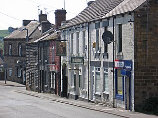
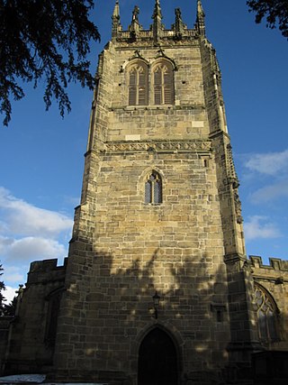
The gargoyled church of St Andrews is situated in Rectory Lane and was built over a monastery. There is an area named Abbotside close to the church. [3] The church of England village school, is also called St Andrews and is situated next to the church. It is said that there is a tunnel which runs under the church yard, across the field and eventually comes out at Abbotside. The tunnel is believed to have been used in Tudor times during the reign of Henry VIII as a safe passage by monks from the abbey. At the other end of the village towards Yate, there is a small lane called Cowship Lane. In the village there is a post office, garage and a pub called The Royal Oak. [4]
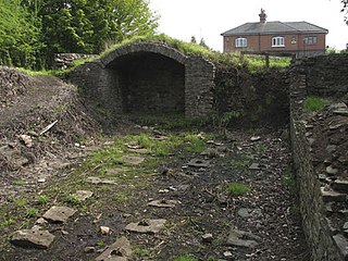
There were several coal mines in Cromhall which worked two seams of coal, the "Top" and "Bottom". [5] The thickness varied "in places being thirty inches thick and in others six inches or dwindled away altogether". [6] The Old Engine works operated from 1774 to 1795, was resumed in 1815 but soon failed before being reopened again in 1819. A new colliery, to the south of the earlier works, was started in about 1827 but that too had closed by 1854. The remains of the engine house at the New Engine Works and the top of the shaft, now completely filled in, are still visible. [7]
The author and writer on natural history Anthony Collett was born here, where his father was the rector. He was the nature correspondent for The Times during the 1910s and 1920s. [8]
The Parish Church of St Andrew is a Grade I listed building and the Old Rectory is listed at Grade II. [9]

Thornhill is a village on the southern outskirts of Dewsbury in Kirklees, West Yorkshire, England. Historically part of the West Riding of Yorkshire, Thornhill was absorbed into Dewsbury County Borough in 1910. The village is located on a ridge on the south side of the River Calder. Dewsbury, Ossett and Wakefield are close by. Its parish church houses a collection of Anglo-Saxon crosses.

Charfield is a village and civil parish in Gloucestershire, England, south-west of Wotton-under-Edge near the Little Avon River and the villages of Falfield and Cromhall. The parish includes the hamlet of Churchend.
Falfield is a village, located near the northern border of the South Gloucestershire district of Gloucestershire, England on the southern edge of the Berkeley Vale, to the east of the River Severn and just falling into the boundary of the Cotswolds. It is the last parish on the northern boundary of South Gloucestershire. The area has a Wotton-under-Edge (GL12) post code and so is often incorrectly listed as being in the Stroud district of Gloucestershire. Falfield is one of the longest villages in England, alongside local village Cromhall.
Worsbrough is a district to the south of Barnsley in the metropolitan borough of Barnsley, South Yorkshire, England. Before 1974, Worsbrough had its own urban district council in the West Riding of Yorkshire. Much of Worsbrough is now part of Barnsley Metropolitan Borough Council's, Worsbrough ward, although certain parts of the historic Worsbrough district, such as Birdwell, Rockley and Blacker Hill, currently lie within neighbouring council wards.

Rossington is a civil parish and former mining village in the Metropolitan Borough of Doncaster in South Yorkshire, England and is surrounded by countryside and the market towns of Bawtry and Tickhill.

Coppull is a village and civil parish in Lancashire, England. It is part of the Borough of Chorley, lies around 300 feet (91 m) above sea level. Its population is around 8,000, having been counted at 8,300 in the 2021Census. It is bounded by Whittle Brook, Clancutt Brook, the River Yarrow, Eller Brook, Hic-Bibi Brook and Stars Brook. Coppull is located between Chorley and Standish, Greater Manchester, to the east of the A49 road near Charnock Richard.

Coalpit Heath is a small village in the civil parish of Westerleigh and Coalpit Heath, in the South Gloucestershire district, in the ceremonial county of Gloucestershire, England, south of Yate and east of Frampton Cotterell.

Winston is a village and civil parish in County Durham, England. It is situated approximately 6 miles (9.7 km) east of Barnard Castle, on a crossroads between the A67 and B6274 roads. According to the 2011 UK Census the population was 431, the parish includes the hamlets of Little Newsham and South Cleatlam.

Frampton Cotterell is a village and civil parish in South Gloucestershire, England, on the River Frome. The village is contiguous with Winterbourne to the south-west and Coalpit Heath to the east. The parish borders Iron Acton to the north and Westerleigh to the south-east, the large town of Yate is 2 miles away. The village is 8 miles north-east of Bristol. The population of the village together with the adjoining village of Winterbourne was 14,694 in 2011. The population of the parish alone was 6,520 at the 2011 census.
Gresford is a village and community in Wrexham County Borough, Wales.

Rangeworthy is a semi-rural farming village in South Gloucestershire, England, nearby communities include Falfield and Charfield. The village population taken at the 2011 census was 675.

Pucklechurch is a civil parish in South Gloucestershire, England, the main settlement of which is the large village of Pucklechurch. The parish also incorporates the hamlet of Shortwood to the west of Pucklechurch village, and Parkfield to the north-west. It has a current population of just over 3200 based on the 2021 census data. The village dates back over a thousand years and was once the site of a royal hunting lodge, as it adjoined a large forest.

Edlington is a town and civil parish in the City of Doncaster, South Yorkshire, England, lying to the south west of Doncaster and Warmsworth. It has a population of 8,276. The original parish town of Edlington is now known as Old Edlington; adjacent, and to the north, is New Edlington. It is often referred to by locals as 'Edlo'. Since 1974 Edlington has been part of the Metropolitan Borough of Doncaster in the metropolitan county of South Yorkshire. It had, since 1894, formed part of Doncaster Rural District in the West Riding of Yorkshire.
Ram Hill Colliery, was a privately owned colliery in the Coalpit Heath area north-east of Bristol, England. It operated between about 1825 and 1865.

Coates is a village and civil parish situated in Cotswold District, Gloucestershire, England. It is around 3 miles (4.8 km) west of Cirencester and close to Cirencester Park, part of the Bathurst Estate. It is the nearest village to the source of the river Thames at Thames Head, and it is close to the course of the Foss Way or Fosse Way, the ancient Roman road. The nearest railway station is Kemble. The village population taken at the 2021 census was 491.

Henfield is a hamlet in the civil parish of Westerleigh and Coalpit Heath, in the South Gloucestershire district, in the ceremonial county of Gloucestershire, England. It is between Coalpit Heath and Westerleigh, adjoining the hamlet of Ram Hill immediately to the north.
Fletcher, Burrows and Company was a coal mining company that owned collieries and cotton mills in Atherton, Greater Manchester, England. Gibfield, Howe Bridge and Chanters collieries exploited the coal mines (seams) of the middle coal measures in the Manchester Coalfield. The Fletchers built company housing at Hindsford and a model village at Howe Bridge which included pithead baths and a social club for its workers. The company became part of Manchester Collieries in 1929. The collieries were nationalised in 1947 becoming part of the National Coal Board.

Ram Hill is a hamlet in the civil parish of Westerleigh and Coalpit Heath, in the South Gloucestershire district, in the ceremonial county of Gloucestershire, England. It is located between Coalpit Heath and Westerleigh and adjoins the hamlet of Henfield immediately to the south. In the Mudge Map 1815, Ram Hill was known as Nutridge Hill, and was linked to Westerleigh by Broad Lane and to Mays Hill by Frog Lane.
The Bristol and Gloucestershire Railway was an early mineral railway, opened in two stages in 1832 and 1834, which connected collieries near Coalpit Heath with Bristol, at the river Avon. Horse traction was used. It was later taken over by the Bristol and Gloucester Railway, and much of the route became part of the main line between Birmingham and Bristol, though that was later by-passed and closed. Part of it now forms the Bristol and Bath Railway Path.
Sitlington is a civil parish in the metropolitan borough of the City of Wakefield, West Yorkshire, England. The parish contains ten listed buildings that are recorded in the National Heritage List for England. Of these, two are listed at Grade II*, the middle of the three grades, and the others are at Grade II, the lowest grade. The parish contains the villages of Middlestown, Netherton, and Overton, and the surrounding countryside. In the parish is the large house, Netherton Hall, which is listed together with associated structures. Also in the parish is the former Caphouse Colliery, later the National Coal Mining Museum for England, which contains two listed buildings. The other listed buildings consist of farm buildings, a wagonway tunnel and its portal, a row of cottages, a milepost, and a church.
{{cite book}}: CS1 maint: numeric names: authors list (link)