
South Gloucestershire is a unitary authority area in the ceremonial county of Gloucestershire, South West England. Towns in the area include Yate, Chipping Sodbury, Thornbury, Filton, Patchway and Bradley Stoke, the latter three forming part of the northern Bristol suburbs. The unitary authority also covers many outlying villages and hamlets. The southern part of its area falls within the Greater Bristol urban area surrounding the city of Bristol.
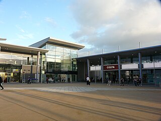
Bradley Stoke is a town in South Gloucestershire, England, situated 6 miles northeast of Bristol, It is near the Severn Estuary of the Bristol Channel, which is an extension of the North Atlantic Ocean, separating South Wales from South West England. Bradley Stoke is bordered by three motorways; the M5 to the north, the M4 to the east and the M32 to the south.

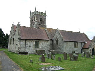
Filton is a town and civil parish in South Gloucestershire, England, 5.5 miles (9 km) north of Bristol. Along with nearby Patchway and Bradley Stoke, Filton forms part of the Bristol urban area and has become an overflow settlement for the city. Filton Church dates back to the 12th century and is designated a Grade II listed building.

Patchway is a town in South Gloucestershire, England, situated 10 km (6.2 mi) north-north west of central Bristol. The town has become an overflow settlement for Bristol and is contiguous with Bristol's urban area, along with the nearby towns of Filton and Bradley Stoke.
Stoke Gifford is a village and parish in South Gloucestershire, England, in the northern suburbs of Bristol. It had around 11,000 residents at the 2001 census, increasing to 15,494 at the 2011 census. It is home to Bristol Parkway station and Stoke Gifford depot, on the London-South Wales railway line, and the Bristol offices of Aviva which took over Friends Life in 2015, Hewlett Packard and the University of the West of England. The parish includes neighbouring Little Stoke, Harry Stoke and Stoke Park. The parish borders Filton, to the south-west, Patchway to the north west, Bradley Stoke to the north and Winterbourne and Hambrook to the east. To the south Stoke Gifford is served by the Bristol Ring Road, south of this a large green area known as the 'Green Lung' stretches to the inner city area of St Werburghs.

Filton Airport or Filton Aerodrome was a private airport in Filton and Patchway, within South Gloucestershire, 4 NM north of Bristol, England.

Bristol North West is a constituency represented in the House of Commons of the UK Parliament since 2017 by Darren Jones of the Labour Party.

Patchway railway station is on the South Wales Main Line, serving the Bristol suburbs of Patchway and Stoke Gifford in South Gloucestershire, England. It is 6 miles (10 km) from Bristol Temple Meads. Its three letter station code is PWY. It is managed by Great Western Railway, who provide all train services at the station, mainly a train every hour in each direction between Cardiff Central and Taunton.

Filton and Bradley Stoke is a constituency represented in the House of Commons of the UK Parliament since 2010 by Jack Lopresti, a Conservative.
Stoke Lodge is a suburb of Bristol, England, developed in the 1950s and early 1960s on farmland to the south of Patchway Common, South Gloucestershire and east of the A38 trunk road. Although the busy London to South Wales railway forms the south-western boundary of the estate, the sound of the trains is moderated by the railway tracks being within a cutting. The new town of Bradley Stoke lies immediately to the east, whilst the suburb of Little Stoke is on its southern edge.
Charlton was the name of a small village or large hamlet in Gloucestershire, England with a Bethel Chapel and Sunday School. It was demolished in the late 1940s. Its site is occupied by part of the derelict runway and safety margins of the former Bristol Filton Airport. The village was located between Filton and what is today the Cribbs Causeway out-of-town commercial and retail area immediately north of Bristol. To the north of the village lay fields and Over Court Deer Park. which is today Bristol Golf Club.

The North Fringe of Bristol, England is a mostly developed area between the northern edge of the administrative city of Bristol and the M4 and M5 motorways. Its eastern edge is usually defined as the M32 motorway. The area falls within South Gloucestershire Council, and is the northern part of Greater Bristol.

North Filton Platform was a railway station which served the northern part of Filton, Gloucestershire, England. It was on the railway line between Filton and Avonmouth, and was situated on the western side of Gloucester Road.
Charlton Hayes is a British mixed-use development located on land north of Filton Airfield and is a new extension to Patchway. Planning permission was granted by the South Gloucestershire Council in 2008 to build 2,200 homes for 6,000 residents. Charlton Hayes was named after the village of Charlton, which was demolished to make way for Filton Airfield extension.

Stoke Gifford depot is a railway depot built for AT300 units from the Hitachi A-train procured under the Intercity Express Programme. The depot is situated between Filton and Stoke Gifford at a junction intersection of the Cross Country Route, South Wales Main Line and the Filton to Avonmouth Docks line. It is operated by Agility Trains as part of its contract to maintain the Class 800 fleet operated by Great Western Railway.

MetroBus is a bus rapid transit system in Bristol, England, created as a joint project between Bristol, North Somerset and South Gloucestershire councils. The first route, service m3, began operations on 29 May 2018, followed by m2 on 3 September and m1 on 6 January 2019.
The Olympus Academy Trust was set up in 2012. Situated within the districts of Bradley Stoke, Filton, Patchway and surrounding areas the trust currently comprises nine South Gloucestershire schools; one all-through, three secondary and five primary academies.
Brabazon is a British mixed-use development located on land on the former Filton Airfield in South Gloucestershire, and is a new extension to the northern fringe of Bristol.
