Chapel Ash

Last updated

Chapel Ash
Chapel Ash, Wolverhampton at night.jpg
Chapel Ash at night
Region
Country England
Sovereign state United Kingdom
Post town Wolverhampton
Postcode district WV
Dialling code 01902
Ambulance West Midlands
List of places
UK
England

Chapel Ash is a small area in Wolverhampton surrounded by the City Centre, Whitmore Reans & Merridale.

Contents

The area is most noted for being the home of Marston's, where the Park Brewery produces the well-known Banks's range of ales

History

Owing to its prominent position on the London to Holyhead road, Chapel Ash has always been an important thoroughfare, though it didn't reach its current stage of urbanisation until the 1870s. The name, 'Chapel Ash' is believed to refer to a Chapel & burial ground referred to in the 16th century, to the west of the town centre – William Yates' '1775 Map of the County of Stafford' has the name written next to the junction of the roads from Bridgnorth and Shrewsbury, the possible site of the medieval chapel. In 1823, Darlington Street had been constructed, linking Wolverhampton's 'High Green' (now Queen Square) to the westward route out of the town – still rural at this time. Some twenty six years later, St Mark's Church was constructed. By 1871, the majority of the buildings we see today in Chapel Ash were in place. From 1875 onwards, Park Brewery was up and running. The area was quite prosperous until the coming of the Ring Road, which cut Chapel Ash off from the town centre during the 1970s. [1]

Today

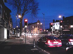
Chapel Ash is dominated by an arterial route out of the city, which splits into three; the first is the continuation of the A41 road from London to Holyhead (via Telford and Shrewsbury), the second is the A454 to Bridgnorth in Shropshire, and the third is a smaller route to the adjacent area of Merridale, Penn and Bradmore. Housing is predominately Victorian era dwellings, with a mix of early villas, later terraces and some local council social housing and private homes built between the 1920 – 1950 period.

Chapel Ash has a variety of different businesses based in the area, including a Harley-Davidson dealership and an independent motorcycle sales and service outlet, a tattoo parlour (Tattoo Palace), an Italian restaurant (Bella), art shop, recruitment agency, Dixon's Paints, estate agencies and bathroom furnishings. There are many food takeaway stores, a Barclays bank and People Plus Recruitment. Banks's Park Brewery still dominates the Chapel Ash area. [2] Wolverhampton's former Eye Infirmary is based at the junction of Compton Road and Merridale Road.

Chapel Ash has been regularly criticised for the poor condition of many of the commercial properties, with features in the local press highlighting several aspects of the area, [3] though the area has benefitted from recent refurbishment of some properties, construction of the new £2.25 million Lifespring church on Clifton Street, [4] and development of a new £65 million Sainsburys store on Raglan Street. [5]

Junction Festival

An annual arts and music festival has been held in the area each August since 2011, featuring street art, an outdoor stage and live music in local pubs. [6]

Public houses

Chapel Ash is well served by three local pubs – The Combermere Arms, The Clarendon Hotel and The Alexandra.

The Clarendon Hotel is situated next to Banks's Brewery at the junction of Chapel Ash and Lovatt Street. It has recently (October 2016) benefited from a major refurbishment.

Related Research Articles

<span class="mw-page-title-main">Marston's Brewery</span> British pub and hotel chain

Marston's plc is a British pub and hotel operator. Founded by John Marston in 1834, it is listed on the London Stock Exchange. Marston's disposed of its brewing operations in 2020, selling the assets to a newly formed joint venture with the Carlsberg Group to create the Carlsberg Marston's Brewing Company (CMBC), in which Marston's plc holds a 40% share.

<span class="mw-page-title-main">Bridgnorth</span> Human settlement in England

Bridgnorth is a town and civil parish in Shropshire, England. The River Severn splits it into High Town and Low Town, the upper town on the right bank and the lower on the left bank of the River Severn. The population at the 2011 Census was 12,079.

<span class="mw-page-title-main">Brierley Hill</span> Human settlement in England

Brierley Hill is a town and electoral ward in the Metropolitan Borough of Dudley, West Midlands, England, 3 miles south of Dudley and 1 mile north of Stourbridge. Part of the Black Country and in a heavily industrialised area, it has a population of 13,935 at the 2011 census. It is best known for glass and steel manufacturing, although industry has declined considerably since the 1970s. One of the largest factories in the area was the Round Oak Steelworks, which closed down and was redeveloped in the 1980s to become the Merry Hill Shopping Centre. Brierley Hill was originally in Staffordshire.

Compton is a suburb of Wolverhampton, West Midlands, England. It is located to the west of Wolverhampton city centre on the A454, within the Tettenhall Wightwick ward.

<span class="mw-page-title-main">Shifnal</span> Town and civil parish in Shropshire, England

Shifnal is a market town and civil parish in Shropshire, England, about 4 miles (6 km) east of Telford, 17 miles (27 km) east of Shrewsbury and 13 miles (20 km) west-northwest of Wolverhampton. It is near the M54 motorway and A5 road aka Watling Street. At the 2001 census, it had a population of 6,391, increasing to 6,776 at the 2011 census.

<span class="mw-page-title-main">Rail transport in Shropshire</span> Overview of rail transport in Shropshire, England

The English county of Shropshire has a fairly large railway network, with 19 National Rail stations on various national lines; there are also a small number of heritage and freight lines, including the famous heritage Severn Valley Railway running along its eastern border with Worcestershire.

<span class="mw-page-title-main">Wolverhampton–Shrewsbury line</span> Railway line serving between Wolverhampton and Shrewsbury

The Wolverhampton–Shrewsbury line is the railway line from Wolverhampton to Shrewsbury via Wellington; it was originally built by the Shrewsbury and Birmingham Railway. The line is double track throughout, with rarely used relief sidings at Cosford and four tracks through Wellington station.

<span class="mw-page-title-main">Shrewsbury railway station</span> Grade II listed railway station in Shropshire, England

Shrewsbury railway station is in Shrewsbury, Shropshire, England. Built in 1848, it was designated a grade II listed building in 1969.

Park, or Park Ward, is a ward of Wolverhampton City Council, West Midlands. It is located to the west of the city centre, and covers parts of the suburbs Bradmore, Compton, Finchfield, Merridale, Newbridge and Whitmore Reans. It borders the St Peter's, Graiseley, Merry Hill, Tettenhall Wightwick and Tettenhall Regis wards. It forms part of the Wolverhampton South West constituency.

Graiseley is both an inner-city area of Wolverhampton, situated immediately to the south-west of the city centre, and the name of a ward of Wolverhampton City Council.

<span class="mw-page-title-main">Claregate</span>

Claregate is a suburb of Wolverhampton, West Midlands, England. It is north west of Wolverhampton city centre, within the Tettenhall Regis ward.

Merridale is an area of Wolverhampton, West Midlands, England. It is situated to the south-west of the city centre, on the border of the city council's Graiseley and Park wards.

<span class="mw-page-title-main">Stafford railway station</span> Railway station in Staffordshire, England

Stafford railway station is a major interchange railway station in Stafford, Staffordshire, England, and is the second busiest railway station in Staffordshire, after Stoke-on-Trent. The station serves the market and county town, as well as surrounding villages. The station lies on the junction of the Trent Valley line, the Birmingham Loop/Rugby–Birmingham–Stafford line, and the West Coast Main Line.

<span class="mw-page-title-main">Wolverhampton station</span> Railway station and tram stop in Wolverhampton, England

Wolverhampton station is a railway station in Wolverhampton, West Midlands, England on the Birmingham Loop of the West Coast Main Line. It is served by Avanti West Coast, CrossCountry, Transport for Wales and West Midlands Trains services, and was historically known as Wolverhampton High Level. It is also a West Midlands Metro tram stop.

<span class="mw-page-title-main">Sandwell & Dudley railway station</span> Railway station in the West Midlands, England

Sandwell & Dudley railway station is on the Birmingham Loop of the West Coast Main Line, on the outskirts of Oldbury. The name of the station is somewhat misleading; the station is actually located between Oldbury and West Bromwich, and not near Dudley. The nearest station to the town of Dudley is Dudley Port.

<span class="mw-page-title-main">Wrexham General railway station</span> Railway station in Wrexham, Wales

Wrexham General is the main railway station serving the city of Wrexham, north-east Wales, and one of the two serving the city, alongside Wrexham Central. It is currently operated by Transport for Wales, but services are also provided by Avanti West Coast who operate a service to London Euston. Until January 2011 Wrexham & Shropshire also operated from here to London Marylebone.

<span class="mw-page-title-main">Telford Central railway station</span> Railway station in Shropshire, England

Telford Central railway station serves the town of Telford, Shropshire, England. It is located on the Wolverhampton to Shrewsbury Line 15+12 miles (24.9 km) north west of Wolverhampton and is operated by West Midlands Trains. It is situated close to the Telford Shopping Centre, the main commercial district of the town.

<span class="mw-page-title-main">Codsall railway station</span> Railway station in Staffordshire, England

Codsall railway station serves the village of Codsall in Staffordshire, England.

<span class="mw-page-title-main">M54 motorway</span> Motorway in England

The M54 is a 23-mile (37 km) east-west motorway in the counties of Shropshire and Staffordshire, England. It is also referred to as the Telford motorway, after the road's primary westbound destination, the town of Telford. It cost £65 million to construct, and is two-lane dual carriageway for the majority of its length, with sections of three-lane.

<span class="mw-page-title-main">Wolverhampton</span> City in the West Midlands, England

Wolverhampton is a city and metropolitan borough in the West Midlands, England. The population was 263,700 in 2021. People from the city are called "Wulfrunians". The city is located 12 miles (19 km) north-west of Birmingham.

References

  1. Chapel Ash Conservation Area Appraisal & Management Proposals (March 2007) "Archived copy" (PDF). Archived from the original (PDF) on 5 March 2012. Retrieved 2010-11-23.{{cite web}}: CS1 maint: archived copy as title (link)
  2. "Banks's". Marston's Beer Company. Archived from the original on 13 April 2011. Retrieved 5 September 2013.
  3. "Millionaire says city is just like skid row « Express & Star". www.expressandstar.com. Archived from the original on 19 January 2010.
  4. "New church approved for Chapel Ash site". Express & Star. 2 February 2011. Retrieved 5 September 2013.
  5. "Delay on Wolverhampton Sainsbury's store start". Express & Star. 6 March 2013. Retrieved 5 September 2013.
  6. "Wolverhampton set for festival fun up the Junction". Express & Star. 30 August 2011. Retrieved 5 September 2013.

52°35′06″N2°08′17″W / 52.5851°N 2.1380°W / 52.5851; -2.1380