List of board schools
From these sources: [1] [2] [3] [4] [5] [6] [7]
This is a list of the Birmingham board schools, built between the Elementary Education Act 1870 (33 & 34 Vict. c. 75) which established board schools, and the Education Act 1902, which replaced school boards with local education authorities. Most of the board schools were designed by the firm Martin & Chamberlain (M&C).
From these sources: [1] [2] [3] [4] [5] [6] [7]
Using source: [3]
Using source: [5]
| Birmingham Board Schools | |||||||
|---|---|---|---|---|---|---|---|
| Name | Picture | Address, Notes | Architect | Grid reference | Coordinates | Grade | Images of England link |
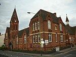
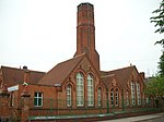
| Clifton Road School | 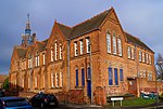 | Clifton Road School, Balsall Heath. 1878 by Kings Norton School Board. Now used by St Paul's Trust. [14] | 1878 M&C (or George Ingall [9] ) | SP081842 | 52°27′22″N1°52′51″W / 52.4560°N 1.8809°W | ||
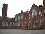
| Tindal Street School |  | Tindal Street School, Balsall Heath, 1880 by Kings Norton School Board. [15] | 1879–80 M&C (or George Ingall [9] ) | SP075841 | 52°27′18″N1°53′19″W / 52.4551°N 1.8886°W | ||
| Birmingham Board Schools | |||||||
|---|---|---|---|---|---|---|---|
| Name | Picture | Address, Notes | Architect | Grid reference | Coordinates | Grade | Images of England link |
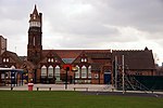
| Camp Hill Circus School |  | Listed as City of Birmingham Polytechnic. Built as the original King Edward VI Camp Hill School for Boys (so not run by the School Board) (used until 1956), and extended with a school for girls. Tower and roof damaged by fire in 1901. [4] Now the Bordesley Centre, run by Muath Welfare Trust. | 1883 M&C [2] | SP083856 | 52°28′05″N1°52′41″W / 52.468°N 1.878°W | Grade II listed | Historic England. "Details from listed building database (1210202)". National Heritage List for England . |
Balsall Heath is an inner-city area of Birmingham, West Midlands, England. It has a diverse cultural mix of people and is the location of the Balti Triangle.
Moseley and Kings Heath is a ward within the constituency of Hall Green, covering the greater part of the Moseley and Kings Heath areas of Birmingham, England.

Selly Oak is an industrial and residential area in south-west Birmingham, England. The area gives its name to Selly Oak ward and includes the neighbourhoods of: Bournbrook, Selly Park, and Ten Acres. The adjoining wards of Edgbaston and Harborne are to the north of the Bourn Brook, which was the former county boundary, and to the south are Weoley, and Bournville. A district committee serves the four wards of Selly Oak, Billesley, Bournville and Brandwood. The same wards form the Birmingham Selly Oak constituency, represented since 2010 by Steve McCabe (Labour). Selly Oak is connected to Birmingham by the Pershore Road (A441) and the Bristol Road (A38). The Worcester and Birmingham Canal and the Birmingham Cross-City Railway Line run across the Local District Centre.

Stirchley is a suburb in south-west Birmingham, England. The name likely refers to a pasture for cattle. The settlement dates back to at least 1658. Prehistoric evidence, Roman roads, and Anglo-Saxon charters contribute to its history. The Worcester and Birmingham Canal and the railways brought industry to the area. Stirchley's development is also linked to industries like screw-making and rubber manufacturing. Originally part of Worcestershire, Stirchley underwent administrative changes in 1911. Residential developments were established alongside the long-standing Victorian terracing which is associated with the suburb.

Birmingham Selly Oak is a constituency in the West Midlands, represented in the House of Commons of the UK Parliament since 2010 by Steve McCabe of the Labour Party.
Cotteridge is an area of Birmingham, England, and part of the Bournville ward. It is about 4 miles (6.4 km) miles south of Birmingham city centre. It has a shopping centre with a mixture of local shops, eateries and national brands.
Bordesley is an area of Birmingham, England, 1.2 miles (2 km) south east of the city centre straddling the Watery Lane Middleway ring road. It should not be confused with nearby Bordesley Green. Commercial premises dominate to the west of the ring road, but much of this area is to be redeveloped. Blocks of residential apartments are planned and set for completion from the mid-2020s onwards. The largely residential area east of the ring road was renamed Bordesley Village following large scale clearance of back-to-back houses and redevelopment in the 1980s and 90s. Bordesley is the real life setting of the BBC series Peaky Blinders, and home to Birmingham City Football Club's ground, St Andrew's.

A441 is an A-road in England which runs from central Birmingham to Cookhill, Worcestershire.

The Church of St Agatha is a parish church in the Church of England in Sparkbrook in Birmingham, England.
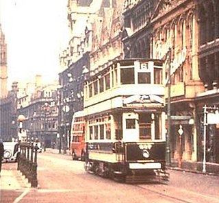
Birmingham Corporation Tramways operated a network of tramways in Birmingham from 1904 until 1953. It was the largest narrow-gauge tramway network in the UK, and was built to a gauge of 3 ft 6 in. It was the fourth largest tramway network in the UK behind London, Glasgow and Manchester.

King's Norton and Northfield Urban District was a local government administrative district in north Worcestershire, England, from 1898 until 1911. Much of its area was afterwards absorbed into the neighbouring Borough of Birmingham, under the Greater Birmingham Scheme, and now constitutes most of the city's southern and southwestern suburban environs.

The Saracen's Head is the name formerly given to a group of late medieval buildings in Kings Norton, Birmingham. The buildings, together with the nearby Old Grammar School, won the BBC Restoration series in 2004. Following the restoration project, the Old Grammar School, Saint Nicolas Church and the Tudor Merchant's House were given the collective name of Saint Nicolas Place.

Highgate is an area of Birmingham, England. Following the Big City Plan of February 2008, Highgate is now a district of Birmingham City Centre. This area is regarded as the site of the original Anglo-Saxon settlement which gave the city of Birmingham its name.
Edward Holmes (1832–1909) was a British architect from Birmingham, England.
Kings Heath is a suburb of south Birmingham, England, four miles south of the city centre. Historically in Worcestershire, it is the next suburb south from Moseley on the A435 Alcester Road. Since 2018 it has been part of the Brandwood and Kings Heath Ward.

Hazelwell is an area in south-west Birmingham, England. Originally a distinct neighbourhood, it has since been incorporated into and split between the suburbs of Stirchley and Kings Heath.