
The Santa Ana River in the U.S. state of California has over 20 significant tributaries and there are over 50 significant streams in the watershed.
The Santa Ana River in the U.S. state of California has over 20 significant tributaries and there are over 50 significant streams in the watershed.
This section needs additional citations for verification .(April 2016) |

The Owyhee River is a tributary of the Snake River located in northern Nevada, southwestern Idaho and southeastern Oregon in the United States. It is 280 miles (450 km) long. The river's drainage basin is 11,049 square miles (28,620 km2) in area, one of the largest subbasins of the Columbia Basin. The mean annual discharge is 995 cubic feet per second (28.2 m3/s), with a maximum of 50,000 cu ft/s (1,400 m3/s) recorded in 1993 and a minimum of 42 cu ft/s (1.2 m3/s) in 1954.

The Feather River is the principal tributary of the Sacramento River, in the Sacramento Valley of Northern California. The river's main stem is about 73 miles (117 km) long. Its length to its most distant headwater tributary is just over 210 miles (340 km). The main stem Feather River begins in Lake Oroville, where its four long tributary forks join—the South Fork, Middle Fork, North Fork, and West Branch Feather Rivers. These and other tributaries drain part of the northern Sierra Nevada, and the extreme southern Cascades, as well as a small portion of the Sacramento Valley. The total drainage basin is about 6,200 square miles (16,000 km2), with approximately 3,604 square miles (9,330 km2) above Lake Oroville.

The San Jacinto River is a 42-mile-long (68 km) river in Riverside County, California. The river's headwaters are in Santa Rosa and San Jacinto Mountains National Monument. The lower portion of the 765-square-mile (1,980 km2) watershed is urban and agricultural land. As a partially endorheic watershed that is contiguous with other Great Basin watersheds, the western side of the San Jacinto Basin is a portion of the Great Basin Divide.
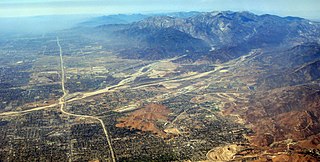
Lytle Creek, California, is an approximately 18-mile-long (29 km) stream in southwestern San Bernardino County near the city of San Bernardino. It is a tributary of Warm Creek, a tributary of the Santa Ana River. The Mormon settlers of San Bernardino named the stream "Lytle Creek" after their leader, Captain Andrew Lytle. The Tongva village of Wa’aachnga was located along Lytle Creek.
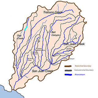
Trampas Canyon is a short tributary of San Juan Creek in southern Orange County the U.S. state of California. It rises in forks on steep slopes of the southern Santa Ana Mountains, and flows north to where it is dammed by Trampas Canyon Dam. Trampas Canyon 1795-006 Dam (33.498359°N 117.587548°W) forms a small lake that branches into four forks running east–west. Exiting the dam, the creek flows north and turns slightly to the west, where it joins San Juan Creek on the left bank, near the confluence of Cañada Gobernadora. Trampas Canyon Creek is ephemeral and only flows during storm events or while Trampas Canyon Dam is releasing, and is not a primary tributary of San Juan Creek.

Temescal Creek is an approximately 29-mile-long (47 km) watercourse in Riverside County, in the U.S. state of California. Flowing primarily in a northwestern direction, it connects Lake Elsinore with the Santa Ana River. It drains the eastern slopes of the Santa Ana Mountains on its left and on its right the western slopes of the Temescal Mountains along its length. With a drainage basin of about 1,000 square miles (2,600 km2), it is the largest tributary of the Santa Ana River, hydrologically connecting the 720-square-mile (1,900 km2) San Jacinto River and Lake Elsinore watersheds to the rest of the Santa Ana watershed. However, flowing through an arid rain shadow zone of the Santa Ana Mountains, and with diversion of ground water for human use, the creek today is ephemeral for most of its length, except for runoff from housing developments and agricultural return flows.
Alberhill is an unincorporated community in Riverside County, California. Alberhill is located 5.5 miles (8.9 km) northwest of Lake Elsinore. It lies at an elevation of 1234 feet. Alberhill was named after C.H. Albers and James and George Hill.

The Temescal Mountains, also known as the Sierra Temescal, are one of the northernmost mountain ranges of the Peninsular Ranges in western Riverside County, in Southern California in the United States. They extend for approximately 25 mi (40 km) southeast of the Santa Ana River east of the Elsinore Fault Zone to the Temecula Basin and form the western edge of the Perris Block.
The Carrizo Creek and Carrizo Wash in California are a stream and an arroyo that the stream flows into, in San Diego County, California, and Imperial County, California.
Rice Canyon Creek is a tributary creek or arroyo of Temescal Creek in Riverside County, California. Rice Canyon Creek has its source at the head of Rice Canyon at an elevation of 3440 feet in the Santa Ana Mountains at 33°41′54″N117°24′11″W east of the 4313 foot peak on the north south divide of the range. It is a wash that runs down from the canyon mouth 33°41′07″N117°27′08″W at 1631 feet to its mouth at its confluence with Temescal Creek near Alberhill, California at an elevation of 1220 feet. Rice Canyon Creek has a tributary, Bishop Canyon Creek which enters the wash on the left a little below the mouth of Rice Canyon at 33°42′05″N117°24′07″W.
Alberhill Canyon is an informally named valley and arroyo in the Temescal Mountains of Riverside County, California. It is named for the former mining settlement and populated place of Alberhill that lay opposite the mouth of the arroyo at its confluence with Temescal Creek.
Summit Valley is a valley along SR 138 in the San Bernardino Mountains, east of Cajon Pass within San Bernardino County, California.

Deep Creek is a tributary of the Mojave River, 23.4 miles (37.7 km) long, in San Bernardino County, California.
Fremont Wash sometimes called Fremont Canyon in its upper reach, is a stream and a valley in the north end of Parowan Valley, in Iron County, Utah. Its mouth lies at its confluence with Little Salt Lake at an elevation of 5,686 feet. Its head is found at 38°07′46″N112°34′36″W, the mouth of Fremont Canyon, an elevation of 6,476 feet.
Sawpit Canyon is a steep valley or canyon in the San Bernardino Mountains of San Bernardino County, California. Its mouth is at an elevation of 3,386 feet. Its source is located at 34°14′43″N117°20′56″W and lies at an elevation of 5,100 feet, just east of Monument Peak. Its creek was a tributary of the West Fork Mojave River, its original mouth now under Silverwood Lake.
West Fork Mojave River is a tributary stream of the Mojave River in the San Bernardino Mountains of San Bernardino County, California. Its mouth lies at an elevation of 2,986 feet at its confluence with Deep Creek, together the source of the Mojave River. The source of the West Fork is at 34°15′52″N117°24′01″W at an elevation of 4,960 feet, on the north side of a saddle between summits on a ridge running west northwest of Sugarpine Mountain. Sawpit Canyon Creek and East Fork of West Fork Mojave River are its tributaries, both of which now feed into Silverwood Lake that was created when the West Fork was obstructed by the Cedar Springs Dam in 1971.
Palm Canyon Wash is an arroyo and tributary ephemeral stream or wash of the Whitewater River, in Riverside County, California.
Bull Canyon is a canyon at the top of Palm Canyon Wash, which is a tributary to the Whitewater River, in Riverside County, California. Bull Canyon and the creek of Palm Canyon Wash heads at 33°36′47″N116°33′23″W, at an elevation of 6,165 feet in the southern western slope of a ridge in the San Jacinto Mountains. The waters of the creek of Palm Canyon Wash are augmented by Bull Canyon Spring at 33°35′22″N116°33′24″W, at an elevation of 5,331 feet / 1,625 meters. The mouth of Bull Canyon is at an elevation of 4,508 feet / 1,374 meters at the head of Palm Canyon. The mouth of an unnamed creek flows north down from Vandeventer Flat into the head of Palm Canyon at its confluence with Palm Canyon Wash at 33°34′08″N116°31′43″W at an elevation of 4,460 feet.
Devil Canyon is a 1.5 mile long canyon on the south slope of the San Bernardino Mountains, in San Bernardino County, California. Its mouth lies at an elevation of 1,759 feet. It heads at 34°12′53″N117°19′43″W, the confluence of East Fork Devil Canyon and West Fork Devil Canyon at an elevation of 2,352 feet.
Eagle Valley is a basin in the Temescal Mountains, of Riverside County, California. It has an elevation of 1,283 feet. The basin is overlooked by summits of the Temescal Mountains on the west, north and east, the tallest is 1,857-foot Arlington Mountain on the northeast. The valley is drained by three streams, the primary one, has its source on the south slope of Arlington Mountain and drains southwestward into Cajalco Canyon and Cajalco Canyon Creek.