
Little Redfish Lake in central Idaho is in the Sawtooth National Recreation Area and Custer County.

Sawtooth National Forest is a National Forest that covers 2,110,408 acres in the U.S. states of Idaho and Utah. Managed by the U.S. Forest Service in the U.S. Department of Agriculture, it was originally named the Sawtooth Forest Reserve in a proclamation issued by President Theodore Roosevelt on May 29, 1905. On August 22, 1972 a portion of the forest was designated as the Sawtooth National Recreation Area (SNRA), which includes the Sawtooth, Cecil D. Andrus–White Clouds, and Hemingway–Boulders wilderness areas. The forest is managed as four units: the SNRA and the Fairfield, Ketchum, and Minidoka Ranger Districts.

The Sawtooth National Recreation Area (SNRA) is a national recreation area in central Idaho, United States that is managed as part of Sawtooth National Forest. The recreation area, established on August 22, 1972, is managed by the U.S. Forest Service, and includes the Sawtooth, Hemingway–Boulders, and Cecil D. Andrus–White Clouds wilderness areas. Activities within the 730,864-acre (2,957.70 km2) recreation area include hiking, backpacking, White water rafting, camping, rock climbing, kayaking, mountain biking, fishing, and hunting.

The Sawtooth Range is a mountain range of the Rocky Mountains in central Idaho, United States, reaching a maximum elevation of 10,751 feet (3,277 m) at the summit of Thompson Peak. It encompasses an area of 678 square miles (1,756 km2) spanning parts of Custer, Boise, Blaine, and Elmore counties, and is bordered to the east by the Sawtooth Valley. Much of the mountain range is within the Sawtooth Wilderness, part of the Sawtooth National Recreation Area and Sawtooth National Forest.

Thompson Peak, at 10,751 feet (3,277 m) above sea level is the highest peak in the Sawtooth Range of Idaho. The summit of Thompson Peak is located within Custer County, although some of the lower portion of the mountain is in Boise County. Thompson Peak is also located within the Sawtooth Wilderness portion of the Sawtooth National Recreation Area, a unit of Sawtooth National Forest. The town of Stanley, Idaho is about 6 miles (9.7 km) northeast of Thompson Peak.

The White Cloud Mountains are part of the Rocky Mountains of the western United States, located in central Idaho, southeast of Stanley in Custer County. The range is located within the Sawtooth National Recreation Area (SNRA) and partially within the Cecil D. Andrus–White Clouds Wilderness.

Alpine Lake is an alpine lake in Custer County, Idaho, United States, located high in the Sawtooth Mountains in the Sawtooth National Recreation Area. The lake is approximately 11.4 miles (18.3 km) southwest of Stanley.

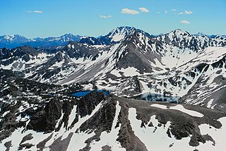
The Bench Lakes are a chain of five small alpine glacial lakes in Custer County, Idaho, United States, located in the Sawtooth Mountains in the Sawtooth National Recreation Area. A cutoff from Sawtooth National Forest trail 101 along Redfish Lake leads to the Bench Lakes. The lakes are drained by an unnamed stream that flows into Redfish Lake, Redfish Lake Creek, and eventually the Salmon River.
The Upper Redfish Lakes are a chain of small alpine glacial lakes in Custer County, Idaho, United States, located in the Sawtooth Mountains in the Sawtooth National Recreation Area. The lakes are drained by an unnamed creek that is a tributary of Redfish Lake Creek, which flows into the Salmon River. There are no trails that lead to the lakes, although they are most easily accessed from Sawtooth National Forest trail 154 along Redfish Lake Creek.
Boulder Lake is an alpine lake in Custer County, Idaho, United States, located in the White Cloud Mountains in the Sawtooth National Recreation Area. The lake is in the Big Boulder Lakes Basin, and is accessed from Sawtooth National Forest trails 601 and 680.

Jimmy Smith Lake is an alpine lake in Custer County, Idaho, United States, located at the northeast end of the White Cloud Mountains on the Bureau of Land Management land just east and downstream of the Sawtooth National Recreation Area border. The lake is accessed from trail 677, which is a 1-mile (1.6 km) improved ATV trail along Big Lake Creek, but there is no motorized vehicle access beyond the lake.
Hook Lake is an alpine lake in Custer County, Idaho, United States, located in the White Cloud Mountains in the Sawtooth National Recreation Area. No trails lead to the lake, but it can be most easily accessed from Sawtooth National Forest trail 601.
Sapphire Lake is an alpine lake in Custer County, Idaho, United States, located in the White Cloud Mountains in the Sawtooth National Recreation Area. No trails lead to the lake, but it can be most easily accessed from Sawtooth National Forest trail 601.
The Big Boulder Lakes are a chain of thirteen small alpine and glacial Paternoster lakes in Custer County, Idaho, United States, located in the White Cloud Mountains in the Sawtooth National Recreation Area. The lakes are located in the upper portion of the Big Boulder Creek watershed east of D. O. Lee Peak. In addition to the lakes listed, the Big Boulder Lakes include the four small lakes that make up The Kettles. Sawtooth National Forest trail 601 along leads to the Big Boulder Lakes.
The Kettles are a chain of four small alpine glacial lakes in Custer County, Idaho, United States, located in the White Cloud Mountains in the Sawtooth National Recreation Area. The lakes are located in the upper portion of the Big Boulder Creek watershed east of D. O. Lee Peak in the uppermost portion of the Big Boulder Lakes Basin. Sawtooth National Forest trail 601 along leads to the Big Boulder Lakes.

The Four Lakes are a chain of four small glacial Paternoster lakes in Custer County, Idaho, United States, located in the White Cloud Mountains in the Sawtooth National Recreation Area. The lakes are located in the upper portion of the Little Boulder Creek watershed upstream of Quiet Lake and east of Patterson Peak. No trails lead to the Four Lakes Basin.
The Boulder Chain Lakes are a chain of thirteen alpine and glacial Paternoster lakes in Custer County, Idaho, United States, located in the White Cloud Mountains in the Sawtooth National Recreation Area. The lakes are located in the upper portion of the Little Boulder Creek watershed north of Merriam Peak. Sawtooth National Forest trail 683 along leads to the Boulder Chain Lakes.
The Casino Lakes are a chain of four alpine glacial lakes in Custer County, Idaho, United States, located in the White Cloud Mountains in the Sawtooth National Recreation Area. The lakes are located on the upper portion of the Big Casino Creek watershed, a tributary of the Salmon River. The lakes have not been individually named, and Sawtooth National Forest trail 646 leads to the lakes.

Merriam Peak, at 10,920 feet (3,330 m) is one of the peaks of the White Cloud Mountains of Custer County, Idaho. It was named for John H. Merriam who played an instrumental role in protecting the area from being mined for molybdenum. Merriam Peak is located in the middle of the range just north of Castle Peak, the highest point in the range. The peak is located in the White Clouds roadless area of Sawtooth National Recreation Area.
The Sawtooth Valley is a valley in the Western United States, in Blaine and Custer counties in central Idaho, United States.

