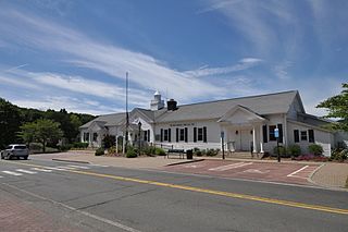
New Fairfield is a town in Fairfield County, Connecticut, United States. The population was 13,579 at the 2020 census. New Fairfield is one of five towns that surround Candlewood Lake, the largest lake in Connecticut. The town is located 55 miles (89 km) northeast of New York City, making it part of the New York metropolitan area. The town is part of the Western Connecticut Planning Region.
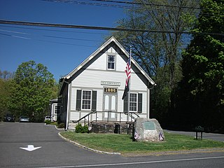
Sherman is the northernmost and least populous town of Fairfield County, Connecticut, United States. The population was 3,527 at the 2020 census. The town is part of the Western Connecticut Planning Region. The town was formed in 1802 from the northern part of New Fairfield. It is named for Roger Sherman, the only person who signed all four founding documents of the United States of America. He also had a cobblers shop in the north end of town which has been reconstructed behind the Northrup House in the center of town.

Indian Lake is a town in Hamilton County, New York, United States. The population was 1,352 at the 2010 census. The name is from a lake of the same name that is largely inside the town. There are no permanent stop lights in the town. Law enforcement is provided by New York State Troopers and Hamilton County Sheriff's Office.
Long Lake is a town in Hamilton County, New York, United States. The population was 791 at the 2020 census.

Webb is the northernmost town in Herkimer County, New York, United States. As of the 2020 Census it had a population of 1,797.

Springfield is a town in Otsego County, New York, United States. The population was 1,358 at the 2010 census. It is located at the northern county line of Otsego County and is approximately 50 mi (80 km) west of Schenectady.

Colton is a town in St. Lawrence County, New York, United States. The population was 1,451 at the 2010 census. The town, originally named "Matildaville", is named after early settler Jesse Colton Higley.

Piercefield is a town in St. Lawrence County, New York, United States. The population was 310 at the 2010 census.
Wells is a town in Rutland County, Vermont, United States. As of the 2020 census, the town had a total population of 1,214.

Lake Hopatcong is the largest freshwater body in New Jersey, United States, about 4 square miles (10 km2) in area. Located 30 miles (48 km) from the Delaware River and 40 miles (64 km) from Manhattan, New York City, the lake forms part of the border between Sussex and Morris counties in the state's northern highlands region.

Squantz Pond State Park is a public recreation area located 10 miles (16 km) north of Danbury in the town of New Fairfield, Connecticut. The state park encompasses 172 acres (70 ha) on the southwestern shore of 270-acre (110 ha) Squantz Pond, offering opportunities for boating, swimming, fishing, and hiking. The park is bordered on the west by Pootatuck State Forest and is managed by the Connecticut Department of Energy and Environmental Protection.

Tupper Lake is located in the state of New York in the United States. The lake is in the Adirondack Park and crosses the county lines of St. Lawrence County and Franklin County.
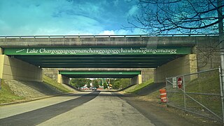
Lake Chaubunagungamaug, also known as Webster Lake, is a lake in the town of Webster, Massachusetts. It is located near the Connecticut border and has a surface area of 1,442 acres. Since 1921, the lake has also been known by a much longer name having 45 letters comprising fourteen syllables: Lake Chargoggagoggmanchauggagoggchaubunagungamaugg. The lake has become famous beyond Central Massachusetts for having the longest name of any geographic feature in all of the United States.

The Red Hill River is a 6.5-mile-long (10.5 km) river in the Lakes Region of central New Hampshire in the United States. It is a tributary of Lake Winnipesaukee, part of the Merrimack River watershed.

Wappinger Creek is a 41.7-mile-long (67.1 km) creek which runs from Thompson Pond to the Hudson River at New Hamburg in Dutchess County, New York, United States. It is the longest creek in Dutchess County, with the largest watershed in the county.

The Sebec River is a tributary of the Piscataquis River in Piscataquis County, Maine. From the outflow of Sebec Lake in Sebec, the river runs 10.0 miles (16.1 km) east and southeast to its confluence with the Piscataquis in Milo.
Blackfoot Pond is a small lake northwest of Old Forge in Herkimer County, New York. It drains south via an unnamed creek which flows into Little Simon Pond.
