
Coshocton County is a county located in the U.S. state of Ohio. As of the 2020 census, the population was 36,612. Its county seat and largest city is Coshocton. The county lies within the Appalachian region of the state. The county was formed on January 31, 1810, from portions of Muskingum and Tuscarawas Counties and later organized in 1811. Its name comes from the Delaware Indian language and has been translated as "union of waters" or "black bear crossing". Coshocton was mentioned by David Zeisberger in his diary from the 1780s using the German spelling "Goschachgünk". The Coshocton, OH Micropolitan Statistical Area includes all of Coshocton County.

Dresden is a village in Muskingum County, Ohio, United States, along the Muskingum River at the mouth of Wakatomika Creek. The population was 1,650 at the 2020 census. It is part of the Zanesville micropolitan area. It was incorporated on March 9, 1835.
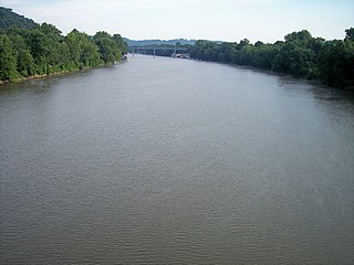
The Muskingum River is a tributary of the Ohio River, approximately 111 miles (179 km) long, in southeastern Ohio in the United States. An important commercial route in the 19th century, it flows generally southward through the eastern hill country of Ohio. Via the Ohio, it is part of the Mississippi River watershed. The river is navigable for much of its length through a series of locks and dams.

The Little Muskingum River is a tributary of the Ohio River, approximately 65 mi (105 km) long, in southeast Ohio in the United States.
The Tuscarawas River is a principal tributary of the Muskingum River, 129.9 miles (209 km) long, in northeastern Ohio in the United States. Via the Muskingum and Ohio rivers, it is part of the watershed of the Mississippi River, draining an area of 2,590 square miles (6,700 km2) on glaciated and unglaciated portions of the Allegheny Plateau.

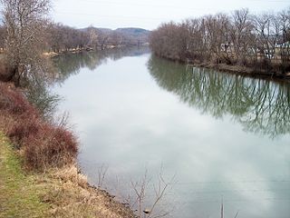
The Walhonding River is a principal tributary of the Muskingum River, 23.5 miles (37.8 km) long, in east-central Ohio in the United States. Via the Muskingum and Ohio Rivers, it is part of the watershed of the Mississippi River. It drains an area of 2,252 square miles (5,830 km2).

The Kokosing River (ko-KO-sing) is a tributary of the Walhonding River, 57.2 miles (92.1 km) long, in east-central Ohio in the United States. Via the Walhonding, Muskingum and Ohio Rivers, it is part of the watershed of the Mississippi River, draining an area of 482 square miles (1248 km2). Etymologically, "Kokosing" translates roughly to "River of Little Owls." The Kokosing River rises in Morrow County, northeast of Mount Gilead, and initially flows southwardly. It turns eastwardly near Chesterville and flows through Knox and Coshocton Counties, passing the communities of Mount Vernon, Gambier and Howard. In western Coshocton County the Kokosing joins the Mohican River to form the Walhonding River, about 2 miles (3 km) northwest of Nellie.

The Licking River is a tributary of the Muskingum River, about 40 mi (65 km) long, in central Ohio in the United States. Via the Muskingum and Ohio Rivers, it is part of the watershed of the Mississippi River.
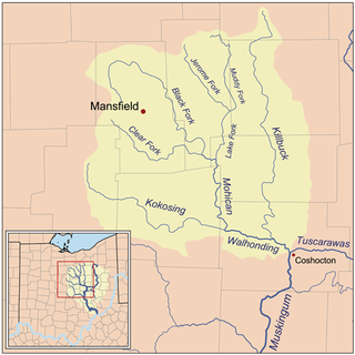
Killbuck Creek is a tributary of the Walhonding River, 81.7 mi (131.5 km) long, in north-central Ohio in the United States. Via the Walhonding, Muskingum and Ohio Rivers, it is part of the watershed of the Mississippi River. It drains an area of 613 mi² (1588 km²).

Wills Creek is a tributary of the Muskingum River, 92.2 mi (148.4 km) long, in eastern Ohio in the United States. Via the Muskingum and Ohio Rivers, it is part of the watershed of the Mississippi River. It drains an area of 853 mi2 (2,209 km2).

Moxahala Creek is a tributary of the Muskingum River, 29.2 miles (47.0 km) long, in southeastern Ohio in the United States. Via the Muskingum and Ohio Rivers, it is part of the watershed of the Mississippi River, draining an area of 301 square miles (780 km2)
Wakatomika Creek is a tributary of the Muskingum River, 42.6 mi (68.6 km) long, in central Ohio in the United States. Via the Muskingum and Ohio Rivers, it is part of the watershed of the Mississippi River, draining an area of 234 mi² (606 km²)

Tunnel Hill is an unincorporated community in central Bedford Township, Coshocton County, Ohio, United States. It lies in the valley of the Little Wakatomika Creek a few miles south of Warsaw, along State Route 60 at its intersection with State Route 541.
Wakatomika is an unincorporated community in central Washington Township, Coshocton County, Ohio, United States. Wakatomika is located on the Little Wakatomika Creek, and lies along State Route 60.

State Route 26 is a 67-mile-long (108 km) north–south route in south eastern Ohio spanning from SR 7 in Marietta to SR 148 between Jerusalem and Bethesda. SR 26 also passes through Graysville and Woodsfield. Where the state route designation ends in Wayne Township, the road continues north as Belmont County Road 26 where it connects to the Barkcamp State Park and the National Road. Much of the route parallels the Little Muskingum River and travels through the heart of Wayne National Forest's Marietta Unit.

The Mohican River is a principal tributary of the Walhonding River, about 40 miles (64 km) long, in north-central Ohio in the United States. Via the Walhonding, Muskingum and Ohio Rivers, it is part of the watershed of the Mississippi River, draining an area of 999 square miles (2,590 km2).
Raccoon Creek is a 114-mile-long (183 km) stream that drains parts of five Ohio counties in the United States. It originates in Hocking County, Ohio. It flows through Vinton County and Gallia County and a corner of Meigs County. Its largest tributary, Little Raccoon Creek, arises in Jackson County. The watershed also includes part of Athens County, drained by another tributary, Hewett Fork. The other major tributaries are Elk Fork, located entirely in Vinton County, and Brushy Fork, which is mostly in Vinton County with a small area in Hocking County.

Beaver Creek is a large creek in Lorain County, Ohio, USA. It flows through the township of Amherst, and through the western end of the corporation-limits of the City of Lorain, and into Lake Erie.
Evans Creek is a stream in Coshocton and Tuscarawas counties in the U.S. state of Ohio. It is a tributary of the Tuscarawas River.
Kekewepelethy, also known as Captain Johnny, was the principal civil chief of the Shawnees in the Ohio Country during the Northwest Indian War (1786–1795). He first came to prominence during the American Revolutionary War (1775–1783), in which he, like most of his fellow Mekoche Shawnees, initially sought to remain neutral. He joined the war against the United States around 1780, moving to Wakatomika, a Shawnee town known for its militant defense of the Ohio Country.