New Braunfels National Airport is a public use airport in Guadalupe County, Texas, United States. It is owned by the city of New Braunfels and located four nautical miles east of its central business district. Formerly known as New Braunfels Regional Airport, it is included in the National Plan of Integrated Airport Systems for 2011–2015, which categorized it as a general aviation facility.
Hearne Municipal Airport is a city-owned, public-use airport located one nautical mile (1.85 km) southwest of the central business district of Hearne, a city in Robertson County, Texas, United States.
Springdale Municipal Airport is a public use airport in Washington County, Arkansas, United States. It is owned by the City of Springdale and located one nautical mile (2 km) southeast of its central business district. This airport is included in the National Plan of Integrated Airport Systems for 2011–2015, which categorized it as a general aviation facility.
Elkin Municipal Airport is a public airport in Surry County, North Carolina, United States, three miles northeast of Elkin. It is owned by the Town of Elkin; the National Plan of Integrated Airport Systems for 2011–2015 called it a general aviation facility.

Enterprise Municipal Airport is a city-owned, public-use airport located three nautical miles (6 km) west of the central business district of Enterprise, a city in Coffee County, Alabama, United States. It is included in the National Plan of Integrated Airport Systems for 2011–2015, which categorized it as a general aviation facility.

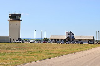
Arlington Municipal Airport is five miles south of Arlington, in Tarrant County, Texas. The airport is at the intersection of Interstate 20 and South Collins Road; it is a reliever airport for Dallas/Fort Worth International Airport and Dallas Love Field.
North Little Rock Municipal Airport is a public use airport in Pulaski County, Arkansas, United States. It is owned by the City of North Little Rock and located four nautical miles north of its central business district.
Monticello Municipal Airport, also known as Ellis Field, is a public-use airport located two nautical miles east of the central business district of Monticello, in Drew County, Arkansas, United States. It is owned by the City of Monticello.

Clinton Municipal Airport is a city-owned public-use airport located one nautical mile (2 km) northeast of the central business district of Clinton, a city in Van Buren County, Arkansas, United States.
Philadelphia Municipal Airport is a public use airport in Neshoba County, Mississippi, United States. It is owned by the City of Philadelphia and located two nautical miles (4 km) northwest of its central business district. This airport is included in the National Plan of Integrated Airport Systems for 2011–2015, which categorized it as a general aviation facility.
Fort Worth Spinks Airport is a city-owned, public-use airport located 14 nautical miles (26 km) south of the central business district of Fort Worth, in Tarrant County, Texas, United States. It is the newest of the three airports that are owned by the City of Fort Worth and it serves the cities of Fort Worth, Burleson, and Mansfield. The airport is located at the intersection of Interstate 35W and HWY 1187 and serves as a reliever airport for Fort Worth Meacham International Airport and Dallas–Fort Worth International Airport and has Class D designation.
Independence Municipal Airport is a city-owned public-use airport located three nautical miles (6 km) southwest of the central business district of Independence, a city in Buchanan County, Iowa, United States. As per the FAA's National Plan of Integrated Airport Systems for 2009-2013, it is classified as a general aviation airport.
Decatur Municipal Airport is a city-owned public airport two miles (3.7 km) north of Decatur, in Wise County, Texas.
Centerville Municipal Airport is a city-owned public-use airport located three nautical miles (6 km) southwest of the central business district of Centerville, a city in Appanoose County, Iowa, United States. According to the FAA's National Plan of Integrated Airport Systems for 2009–2013, it is categorized as a general aviation airport.
Hot Springs Municipal Airport is a city-owned public-use airport located five nautical miles southeast of the central business district of Hot Springs, a city in Fall River County, South Dakota, United States. According to the FAA's National Plan of Integrated Airport Systems for 2009–2013, it is categorized as a general aviation facility.

Bruce Brothers Huntsville Regional Airport, also known as Huntsville Municipal Airport, is a city-owned, public-use airport located two nautical miles (4 km) northwest of the central business district of Huntsville, a city in Walker County, Texas, United States. It is included in the National Plan of Integrated Airport Systems for 2011–2015, which categorized it as a general aviation facility.
Baker Municipal Airport is a public-use airport located one nautical mile southeast of the central business district of Baker, a city in Fallon County, Montana, United States. The airport is owned by Baker City and Fallon County. It is included in the FAA's National Plan of Integrated Airport Systems for 2011–2015, which categorized it as a general aviation facility.
Morrilton Municipal Airport is a public use airport located two nautical miles southeast of the central business district of Morrilton, in Conway County, Arkansas, United States. It is owned by the City of Morrilton.
Cleburne Regional Airport is a city-owned, public-use airport located two nautical miles (4 km) northwest of the central business district of Cleburne, a city in Johnson County, Texas, United States. Formerly known as Cleburne Municipal Airport, it is included in the National Plan of Integrated Airport Systems for 2011–2015, which categorized it as a general aviation facility.

Granbury Regional Airport is a city-owned, public-use airport located two nautical miles (4 km) west of the central business district of Granbury, a city in Hood County, Texas, United States. Formerly known as Granbury Municipal Airport, it is included in the National Plan of Integrated Airport Systems for 2011–2015, which categorized it as a general aviation facility.
