
Greenland is an island country that is part of the Kingdom of Denmark. It is located between the Arctic and Atlantic oceans, east of the Canadian Arctic Archipelago. Greenland is the world's largest island, it is one of three constituent countries that form the Kingdom of Denmark, along with Denmark and the Faroe Islands; the citizens of these countries are all Danish nationals. Greenland is divided into five municipalities: Sermersooq, Kujalleq, Qeqqata, Qeqertalik and Avannaata. The northeast of the island composes the unincorporated Northeast Greenland National Park. Thule Air Base is also unincorporated, an enclave within Avannaata municipality administered by the United States Space Force. Greenland's capital is Nuuk.
Hans Island is a Canadian and Greenlandic island in the very centre of the Kennedy Channel of Nares Strait in the high Arctic region. The island itself is barren and uninhabited with an area of 1.3 square kilometres (0.50 sq mi), measuring 1,290 by 1,199 metres, and a maximum elevation of 168.17 m (551.7 ft). Its location in the strait that separates Ellesmere Island of Canada from northern Greenland has for years been a border dispute, the so-called Whisky War between the two countries of Canada and Denmark. Hans Island is the smallest of three islands in Kennedy Channel off the Washington Land coast; the others are Franklin Island and Crozier Island. The strait at this point is 35 km (22 mi) wide, placing the island within the territorial waters of both Canada and Denmark (Greenland). A 1,280 m (4,200 ft) long border traverses the island.

The first USS Advance was a brigantine in the United States Navy which participated in an Arctic rescue expedition. Advance was built in 1847 as Augusta in New Kent County, Virginia and loaned to the Navy on 7 May 1850 by Henry Grinnell to participate in the search for Sir John Franklin's Arctic expedition which had been stranded in the frozen north since 1846. After last-minute preparations, the ship, under the command of Lieutenant Edwin J. De Haven and in company with Rescue, put to sea from New York on 23 May 1850.

Johan Carl Christian Petersen was a Danish seaman and interpreter who participated in several expeditions in Northern Canada and Greenland in search of the missing British explorer John Franklin.

Hans Hendrik was a Kalaallit interpreter, Arctic explorer, and the first Inuk to publish an account of his travels. He was born in the southern settlement of Fiskenæsset.

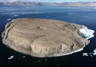
Franklin Island is one of three islands located in Kennedy Channel of Nares Strait in the high Arctic and is part of Avannaata municipality, Greenland.

Kane Basin is an Arctic waterway lying between Greenland and Canada's northernmost island, Ellesmere Island. It links Smith Sound to Kennedy Channel and forms part of Nares Strait. It is approximately 180 kilometres in length and 130 km at its widest.
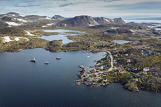
Kulusuk, formerly Kap Dan, is a settlement in the Sermersooq municipality in southeastern Greenland, located on an island of the same name. The settlement population of 241 includes many Danes choosing to live there due to the airport. In the Kalaallisut language, the name of the village means "Chest of a Black Guillemot".

Kaiser Franz Joseph Fjord is a major fjord system in the NE Greenland National Park area, East Greenland.
Sabine Island is an island to the northeast of Wollaston Foreland, previously known as Inner Pendulum Island. It is in the Northeast Greenland National Park area.

The Second Grinnell expedition of 1853–1855 was an American effort, financed by Henry Grinnell, to determine the fate of the Franklin's lost expedition. Led by Elisha Kent Kane, the team explored areas northwest of Greenland, now called Grinnell Land.
Norske Islands, Danish: Norske Øer; meaning 'Norse Islands', is a group of two uninhabited islands of the Greenland Sea, Greenland.

The Geography of Franz Josef Land refers to an island group belonging to Arkhangelsk Oblast of Russia. It is situated in the Barents Sea of the Arctic, north of Novaya Zemlya and east of Svalbard. At latitudes between 80.0° and 81.9° north, it is the most northerly group of islands associated with Eurasia. The extreme northernmost point is Cape Fligely on Rudolf Island. The archipelago consists of 191 ice-covered islands with a total area of 16,134 km2 (6,229 sq mi). It is currently uninhabited. The archipelago is only 900 to 1,110 km from the North Pole, and the northernmost islands are closer to the Pole than any other land except for Canada's Ellesmere Island and Greenland. The largest island is Zemlya Georga which measures 110 km (68 mi) from end to end. The highest point in the archipelago is on Ostrov Viner-Neyshtadt which reaches 620 m (2,034 ft) above sea level. The central cluster of large islands in the midst of the archipelago forms a compact whole, known as Zichy Land, where islands are separated from each other by very narrow sounds that are frozen most of the year.

The Carey Islands are an island group off Baffin Bay, in Avannaata municipality, northwest Greenland. Located relatively far offshore the Carey Islands are the westernmost point of Greenland as a territory. The sea surrounding the islands is clogged by ice most of the year.
The Bonsall Islands is a small coastal island cluster in the Avannaata municipality, off northwest Greenland.
The McGary Islands is a small coastal island group in Avannaata municipality, off NW Greenland.
Peabody Bay is a large bay in northwestern Greenland. Administratively it is part of Avannaata municipality.
Meteorite Island is an island in Baffin Bay, in Avannaata municipality, off NW Greenland.
Iluileq is an uninhabited island in the Kujalleq municipality in southern Greenland.

Ofjord is a fjord in King Christian X Land, eastern Greenland. This fjord is part of the Scoresby Sound system. Administratively it lies in the area of Sermersooq municipality.

