
Pender Island is one of the Southern Gulf Islands located in the Salish Sea, British Columbia, Canada. Pender Island is approximately 34 km2 (13 sq mi) in area and is home to about 2,250 permanent residents, as well as a large seasonal population. Like most of the rest of the Southern Gulf Islands, Pender Island enjoys a sub-Mediterranean climate and features open farmland, rolling forested hills, several lakes and small mountains, as well as many coves and beaches.
The Pacific National Exhibition (PNE) is a nonprofit organization that operates an annual 15-day summer fair, 12-day winter fair, a seasonal amusement park, and indoor arenas in Vancouver, British Columbia, Canada. The PNE fair is held at Hastings Park, beginning in mid-to-late August and ending in early September, usually Labour Day, and in mid-December until Christmas.

Parts of this article have been adapted from the BC Parks website.
Claud Elliott Provincial Park is a provincial park in British Columbia, Canada located on northern Vancouver Island approximately 50 kilometres (31 mi) southeast of Port McNeill, between the Tsitsika River and Bonanza Lake, near the community of Woss.

Juan de Fuca Provincial Park is a provincial park located on the west coast of Vancouver Island in British Columbia, Canada. The park was established on April 4, 1996 by combining three former parks — China Beach, Loss Creek, and Botanical Beach — into one provincial park. It is the location of the majority of the Juan de Fuca Marine Trail, which is a southern compliment to the West Coast Trail within Pacific Rim National Park Reserve.
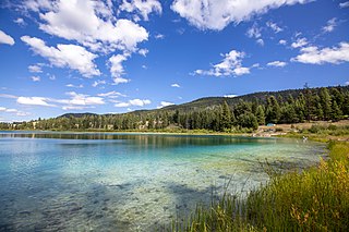
Kentucky Alleyne Provincial Park is a provincial park in British Columbia. The park is located 38 kilometres south of the city of Merritt, and east of the community of Aspen Grove. The park is named for two of its largest lakes, Kentucky Lake and Alleyne Lake. All lakes in the park have a distinctive turquoise colouration.

MacMillan Provincial Park is a 301-hectare (740-acre) provincial park in British Columbia, Canada. Located 25 km (16 mi) west of Qualicum Beach and 16 km (9.9 mi) east of Port Alberni, the park straddles Highway 4 and the Island Rail Corridor in central Vancouver Island. It is nestled on the western shore of Cameron Lake, and protects the delta of the Cameron River. The park is home to a famous, 157-hectare (390-acre) stand of ancient Douglas fir, known as Cathedral Grove, which draws visitors from all over the world. The park provides the only highway-accessible protected old-growth Douglas-fir forest in British Columbia. In 2007 Cathedral Grove made the short list on CBC's competition Seven Wonders of Canada.

Miracle Beach Provincial Park is a provincial park on the eastern shore of Vancouver Island in British Columbia, Canada. Located between Comox and Campbell River, the park includes a foreshore area in the Strait of Georgia, much of the Black Creek estuary, and a forested area. According to its Master Plan, it fulfills primarily a recreational role with a focus on beach play, picnicking, nature appreciation, and camping, and a secondary conservation role with a focus on the natural shoreline and estuary. In support of its recreational focus the park is developed with a day-use parking area with accessible trails leading to the shoreline and a camping area with 200 drive-in sites. The park is also hosts a nature centre building and a sheltered group picnic shelter. Vegetation in the park is typical for the region's second-growth forests with Douglas-fir most prominent. Common associates include Western hemlock, Sitka spruce, red alder and bigleaf maple. Salal and sword fern are the most abundant shrub. Black Creek, which flows through the park, is a spawning area for coho salmon.
Nitinat River Provincial Park is a provincial park in the Canadian province of British Columbia on Vancouver Island.

Port Renfrew is a small unincorporated community located on the south shore of Port San Juan, an inlet on the west coast of Vancouver Island in British Columbia, Canada. Port Renfrew has a population of 262 and has been touted as "the Tall Tree Capital of Canada".

Kennedy Lake is the largest lake on Vancouver Island, British Columbia, Canada. Located north of Ucluelet on the island's central west coast, the lake is formed chiefly by the confluence of the Clayoquot and Kennedy Rivers. Outflow is via a short stretch of the Kennedy River into Tofino Inlet. The lake includes an extensive northern arm called Clayoquot Arm.
Schoen Lake Provincial Park is a provincial park in northeastern Vancouver Island, British Columbia, Canada, located east of the community of Woss Lake and southwest of Sayward. The park lies inside the Nimpkish Valley watershed. On October 28, 1977, the "Class A" park was officially created to protect, exhibit and interpret an example of the natural features and processes of the Insular Mountains Natural Region. The park covers a total area of 8,775 hectares. Within those hectares of park land is a number of lakes, creeks and mountain ranges.
Sproat Lake Provincial Park is a provincial park near Port Alberni in British Columbia, Canada's Vancouver Island. Its name derives from a lake named after 19th century entrepreneur and colonial official Gilbert Malcolm Sproat.

Buttle Lake is a lake on Vancouver Island in Strathcona Regional District, British Columbia, Canada. It is about 23 kilometres (14 mi) long and 1.5 kilometres (0.9 mi) wide, has an area of 28 square kilometres (11 sq mi), is up to 120 metres (394 ft) deep, and lies at an elevation of 221 metres (725 ft). The lake is located between Campbell River and Gold River in Strathcona Provincial Park. The lake is the headwaters of the Campbell River.

təmtəmíxʷtən/Belcarra Regional Park is a 1,100-hectare (2,700-acre) regional park located in Belcarra, Greater Vancouver, British Columbia. It is northeast of the meeting of Burrard Inlet with Indian Arm, beginning near Belcarra Bay and extending to Sasamat Lake. The park is northwest of the Village of Anmore and to the southwest of Buntzen Lake. Apart of its 1,104 hectares, are the 92 hectares of Admiralty Point Lands, ocean waterfront lands in Port Moody.

The Ancient Forest Alliance is a grassroots environmental organization in British Columbia, Canada. It was founded in January 2010, and is dedicated to protecting British Columbia's old-growth forests in areas where they are scarce, and ensuring sustainable forestry jobs in that province.
Lizard Lake may refer to:
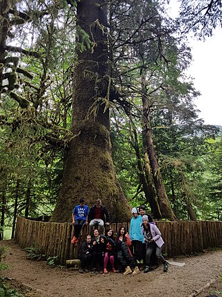
The Harris Creek Sitka Spruce is a large Sitka spruce tree, about 4 metres (13 ft) in diameter, near the creek bed of Harris Creek, off the Pacific Marine Road between Port Renfrew, BC and Honeymoon Bay, BC on Vancouver Island, in British Columbia. Although it is not the largest sitka spruce on Vancouver Island, it is easily accessible and has become a famous tree along the Pacific Marine Loop going from Victoria, BC, through Port Renfrew, Lake Cowichan, and Duncan, BC and returning to Victoria over the Malahat Drive. It is approximately 80 metres (260 ft) tall.

Upper Campbell Lake is a reservoir on Vancouver Island in British Columbia, Canada. The lake was flooded in 1958 for a large hydroelectric project, which raised the water level by 30 metres (98 ft). Crest Creek and headwaters of the Heber River are diverted into the lake. Part of the lake and its watershed is located in Strathcona Provincial Park, and the Strathcona Park Lodge is located on the eastern side. Freshwater fish species in the lake include Cutthroat trout, Rainbow trout and Dolly varden.

The San Juan Valley is a small valley located in the Capital Regional District of Vancouver Island in British Columbia, Canada.
