Llanddona fish weir

Last updated

Llanddona fish weir
Gorad Llanddona
View northeast across Red Wharf Bay - geograph.org.uk - 944068.jpg
Red Wharf Bay with fish weir in the distance
Type fish weir
Location Anglesey, Wales
Coordinates 53°18′29″N4°08′38″W / 53.308°N 4.144°W / 53.308; -4.144 Coordinates: 53°18′29″N4°08′38″W / 53.308°N 4.144°W / 53.308; -4.144
OS grid reference SH 5725 8116
Official nameLlanddona Fish Weir
Designated31 October 2002
Reference no.AN137
Isle of Anglesey UK relief location map.jpg
Red pog.svg
Location in Anglesey

Llanddona fish weir (also known as Welsh : Gorad Llanddona or Welsh : Gorad Fona) is a post-medieval fish trap sited in Llanddona, on the Isle of Anglesey. The fish weir is a scheduled monument.

Contents

Location

Llanddona fish weir is at the far eastern end of the beach at Red Wharf Bay where a band of rocks turns to sand, and is near the estuary of the brook that passes near St Dona's church. [1] [2] [3] The fish weir lies at the edge of the Penmon Historic Landscape Area. [4]

Description

Llanddona fish weir is a V-shaped trap, typically used when trapping fish in tidal waters. [5] [6] The two arms of the V run down the beach, starting below the high-water line and almost meet at the tip of the V just above the low-water line, where the fish are caught in a net or a trap when the tide recedes. [7] The sides of the V-shaped trap can be made of stone, wattle fencing, or both. [7]

At Llanddona the sea is north of the beach, so the western arm, about 300m long, points north-east, and the eastern arm, about 100m long, starts at the edge of the beach and points north-west. [3] [2]

History

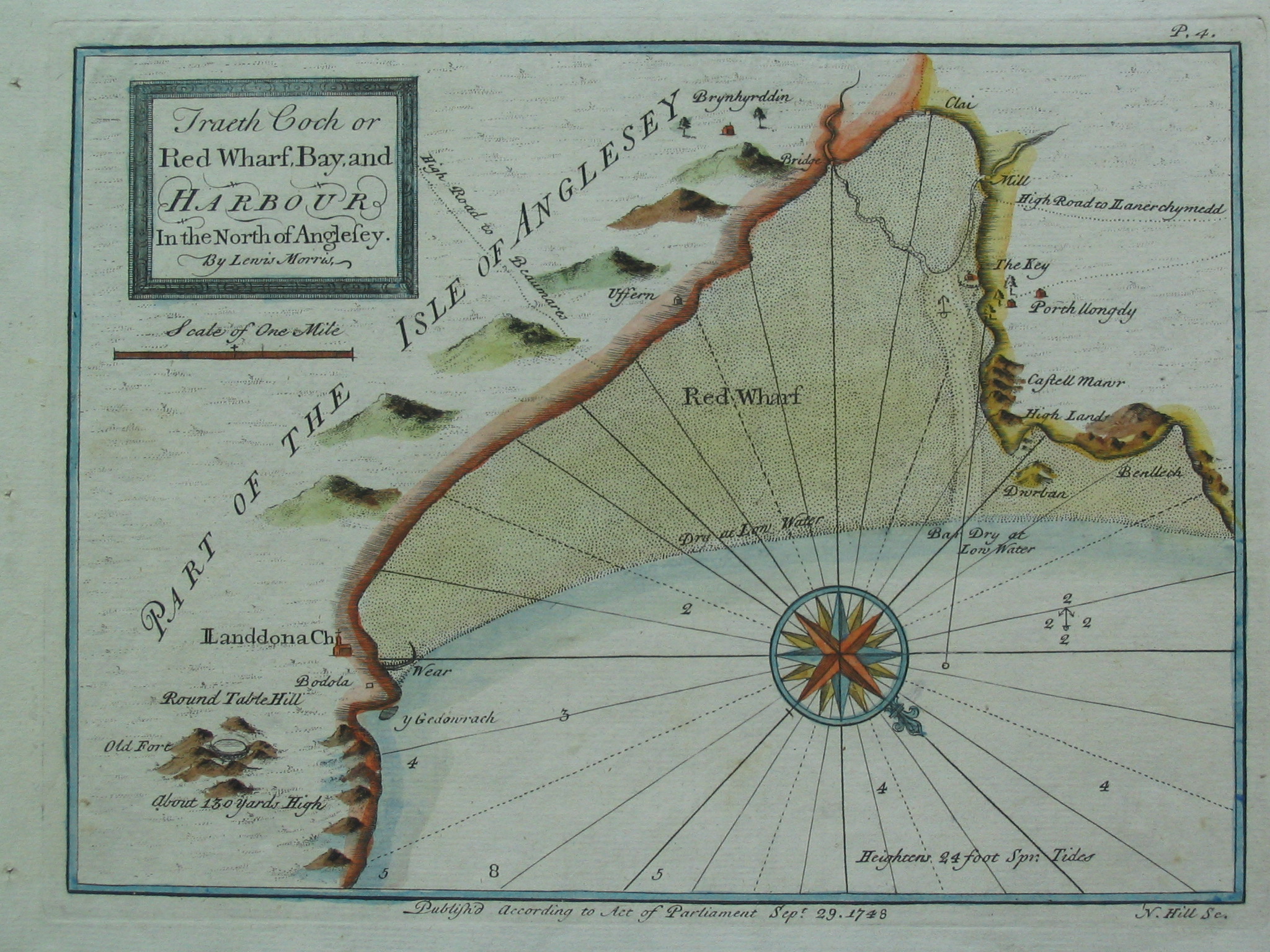
Llanddona fish weir is first mentioned in the 17th century in the records of the Baron Hill estate and is also shown on a chart of 1748 by Lewis Morris, a hydrographer, surveyor and author from Anglesey. [6] [1] [8]

Near the weir there are two buildings named as Godreddi Bach and Godreddi Mawr. The names seem to be a corruption of Goreddi (the plural of gored, meaning weir). [9] This possibly associates the buildings with the weir, and that there may have been more than one weir. [9] Additionally, a double line of stones has been identified on an aerial photograph which may be part of the original construction or part of later rebuilding. [1]

Recent history

Llanddona fish weir was designated as a scheduled monument in 2002 as being of national importance to improve understanding of medieval or post-medieval maritime agricultural practices and possibly containing archaeological information concerning chronology and building techniques. [6]

Access

Llanddona fish weir, like most of the beach at Red Wharf Bay, is covered by the sea at high tide, and even at low tide the apex of the weir is still underwater. [3] The Llanddona circular walk passes near the site of the weir. [10]

See also

Related Research Articles

Bodedern Human settlement in Wales

Bodedern is a village and community in the west of Anglesey, Wales. At the 2001 census, it had a population of 1,074, decreasing slightly to 1,051 at the 2011 census.

Pentraeth Village and community in Anglesey, in north-west Wales

Pentraeth is a village and community on the island of Anglesey, North Wales, at grid reference SH523786. The Royal Mail postcode begins LL75. The community population taken at the 2011 census was 1,178. The village itself having a population of 557.

Moelfre, Anglesey Welsh village on Isle of Anglesea

Moelfre is a village, a community and until 2012 an electoral ward on the north-east coast of the Isle of Anglesey in Wales. The community area covers the village and harbour, and several smaller, dispersed settlements. It includes six scheduled Iron Age hut groups and many other sites of archaeological interest. The harbour was formerly a local fishing port; a lifeboat station has been based here since 1854. Among many shipwrecks off the coast was that of the Royal Charter in 1859. Near the modernised lifeboat station is the RNLI Seawatch Centre. The coastline includes a rocky headland north of the village and a large sandy beach at Lligwy Bay, both traversed by the Anglesey Coastal Path. The 2011 census measured the village population as 710. It was estimated at 614 in 2019.

Fishing weir

A fishing weir, fish weir, fishgarth or kiddle is an obstruction placed in tidal waters, or wholly or partially across a river, to direct the passage of, or trap fish. A weir may be used to trap marine fish in the intertidal zone as the tide recedes, fish such as salmon as they attempt to swim upstream to breed in a river, or eels as they migrate downstream. Alternatively, fish weirs can be used to channel fish to a particular location, such as to a fish ladder. Weirs were traditionally built from wood or stones. The use of fishing weirs as fish traps probably dates back prior to the emergence of modern humans, and have since been used by many societies across the world.

Ynys Gored Goch

Ynys Gored Goch, sometimes Ynys Gorad Goch, is a small island in the Menai Strait between Gwynedd and Anglesey in north Wales. It is situated in the stretch of the strait called the Swellies between Thomas Telford's Menai Suspension Bridge and Robert Stephenson's Britannia Bridge.

Penmon Human settlement in Wales

Penmon is a promontory, village and ecclesiastical parish on the eastern tip of the Isle of Anglesey in Wales, about 3 miles (4.8 km) east of the town of Beaumaris. It is in the community of Llangoed. The name comes from Welsh: pen and Môn, which is the Welsh word for Anglesey. It is the site of a historic monastery and associated 12th-century church. Walls near the well next to the church may be part of the oldest remaining Christian building in Wales. Penmon also has an award-winning beach and the Anglesey Coastal Path follows its shores. Quarries in Penmon have provided stone for many important buildings and structures, including Birmingham Town Hall and the two bridges that cross the Menai Strait. The area is popular with locals and visitors alike for its monuments, tranquillity, bracing air and fine views of Snowdonia to the south across the Menai Strait.

Llaneilian Human settlement in Wales

Llaneilian is a village and community in the Welsh county of Anglesey. It is located in the north east of the island, 2.2 miles (3.5 km) east of Amlwch, 16.5 miles (26.6 km) north west of Menai Bridge and 12.5 miles (20.1 km) north of Llangefni. The community includes the villages and hamlets of Dulas, Llaneilian, Pengorffwysfa, Cerrig Man and Penysarn, Gadfa and Nebo, and at the 2001 census had a population of 1,192, decreasing slightly to 1,186 at the 2011 Census. The parish is crowned by its hill, Mynydd Eilian, a HuMP, popular with walkers and ramblers, and its beach, Traeth Eilian, which is popular with holidaymakers and for watersport activities. At the north easternmost point is Point Lynas,, while Ynys Dulas lies off the North East coast of the island, east of Dulas Bay.

Bryn Gwyn stones

The Bryn Gwyn stones stand about 280 metres (920 ft) to the south-west of Castell Bryn Gwyn, on the low ridge some 2 m (7 ft) above the valley of the Afon Braint on the Isle of Anglesey in Wales.

Tref Alaw Human settlement in Wales

Tref Alaw is a community in Anglesey, north Wales. The community takes in the area west and south west of the Llyn Alaw, a man made reservoir which is also the largest body of water on the island. The community consists of a wide network of dispersed farms, and five settlements. Two small villages, close to each other in the centre of the community area are Llanddeusant and Elim. Llantrisant is a hamlet a mile or so to the south-west of Elim. In the north west is the small village of Llanbabo, and in the far south is the tiny hamlet of Llechgynfarwy, of which the principal building is St Cynfarwy's Church. At the 2001 census the community had a population of 606 inhabitants, reducing to 581 at the 2011 census.

Scheduled monuments in Gwynedd

Gwynedd is a large rural county in North Wales. The northern half includes the high mountains of Snowdonia and the mixed farmland and hills of the Llŷn peninsula, which between them make up much of the former county of Caernarfonshire. The southern part of Gwynedd is the softer coastal and upland landscapes of the former county of Merionethshire. Gwynedd, the second-largest county in Wales, has a total of 497 scheduled monuments. That is too many to have on a single list article, so for convenience the list is divided into three. The 365 prehistoric sites are in two lists, covering 171 sites in former Merionethshire, and 194 sites in former Caernarvonshire. The 132 sites dating from Roman to modern times are included in a single list covering the whole of the county. Gwynedd is a unitary authority comprising most of the two historic counties. In 1974 it also merged with Anglesey, and the merged county was also called Gwynedd. Since 1996 Anglesey has been a separate county again.

Presaddfed Burial Chamber Neolithic burial chamber in Anglesey, Wales, UK

Presaddfed Burial Chamber is a listed monument in Anglesey, north Wales, comprising two Neolithic chamber tombs. It is a scheduled ancient monument and is located a short distance northwest of Bodedern. It is maintained by Cadw.

Din Dryfol

Din Dryfol is a Neolithic burial chamber on Anglesey, in Wales. It is a scheduled monument and is maintained by Cadw. The monument is near Bethel. Three phases of use have been identified, all dating from the Neolithic period.

St Gwenfaens Well

St Gwenfaen's Well is an early medieval holy well in the south west of Holy Island, Anglesey, named after St Gwenfaen, whose cloister was nearby. The site includes substantial remains of a building and is both a scheduled monument and a Grade II listed building. Traditionally, a gift of two white quartz pebbles thrown into the pool can cure mental health problems.

Menai Strait fish weirs

The Menai Strait fish weirs are historically important fishing traps used in the fast-flowing tidal waters of the Menai Strait, which separates Anglesey from the rest of North Wales. The strait was particularly well suited to utilising fish weirs. The tidal waters pull huge volumes of water past the coastline with every tide, and the weirs and traps enabled fish to be concentrated into small holding areas from which they can be readily caught. Such methods are thought to have been used from earliest times, but the submerged and standing remains along both the Anglesey and Gwynedd coasts are from medieval and post-medieval periods, and in some cases were still in use into the 20th century.

Porth Wen Brickworks

Porth Wen Brickworks is a now disused Victorian brickworks which produced fire bricks, made from quartzite (silica) used to line steel-making furnaces. The substantial remains include a number of buildings and the remains of some of the machinery, but has some damage from sea erosion. The site is a scheduled monument.

References

  1. 1 2 3 Llanddona (Report). Gwynedd Archaeological Trust (GAT). GAT PRN 33476. Archived from the original on 24 September 2015. Retrieved 29 July 2016.
  2. 1 2 Anglesey Sheet XIV.NE (Map) (1st ed.). 1:10560. Ordnance Survey. 1888. Retrieved 29 July 2016 via National Library of Scotland.
  3. 1 2 3 RCAHMW. "Llanddona Fish Trap (406349)". Coflein. Retrieved 30 September 2021.
  4. "Penmon Historic Landscapes". Gwynedd Archaeological Trust (GAT). 2010. Archived from the original on 5 August 2016. Retrieved 29 July 2016.
  5. Fish Trap, Llandona (ID PRN7204). in the 'SMR' for Gwynedd Archaeological Trust (GAT). Retrieved 30 September 2021
  6. 1 2 3 Llanddona Fish Weir. National Monuments Record of Wales (NMRW) (Report). Cadw. 31 October 2002 [Scheduled 2002]. Cadw Id: AN137.
  7. 1 2 Bannerman, N. V. Campbell (2011). Flood, Folklore and Fish Weirs (PDF) (Report). p. 3. Retrieved 30 July 2016.
  8. Wiliam, Dafydd Wyn. "Morris, Lewis". Oxford Dictionary of National Biography (online ed.). Oxford University Press. doi:10.1093/ref:odnb/19313.(Subscription or UK public library membership required.)
  9. 1 2 Vousden, Nikola (2014). The Archaeological and Historical Significance of Intertidal Fish Traps at Llanon, Cardigan Bay (Report). Lampeter: University of Wales Trinity Saint David. pp. 32–33. CiteSeerX   10.1.1.655.3206 .
  10. "Circular walk – Llanddona" (PDF). www.visitanglesey.co.uk. Isle of Anglesey County Council . Retrieved 1 August 2016.