Llyn Eigiau

Last updated

Llyn Eigiau
Llyn Eigiau view.jpg
from the summit of Clogwynyreryr
Gwynedd UK relief location map.jpg
Red pog.svg
Llyn Eigiau
Location Snowdonia, Gwynedd, Wales
Coordinates 53°10′8″N3°54′57″W / 53.16889°N 3.91583°W / 53.16889; -3.91583
Type natural, reservoir
Primary inflows Afon Eigiau
Primary outflows Afon Porth-llwyd
Basin  countriesUnited Kingdom
Surface area120 acres (49 ha)
Max. depth32 ft (9.8 m)
The breach in the dam, showing the gully cut by floodwater. Llyn Eigiau breach.jpg
The breach in the dam, showing the gully cut by floodwater.
A second breach was deliberately made in the dam to prevent a re-occurrence. Llyn Eigiau dam.jpg
A second breach was deliberately made in the dam to prevent a re-occurrence.

Llyn Eigiau is a lake on the edge of the Carneddau range of mountains in Snowdonia, Conwy, Wales. The name Eigiau is thought to refer to the shoals of fish which once lived here. Early maps refer to it as Llynyga. It is thought that a small number of Arctic char exist in the lake (as they do in neighbouring Llyn Cowlyd) after they were transferred here from Llyn Peris, and certainly it is one of the few lakes in Wales to have its own natural brown trout. The lake is surrounded by mountains including Pen Llithrig y Wrach.

Contents

Dam

In 1911 a dam ¾ mile long and 35-foot (11 m) high was built across part of its eastern side to supply water for the power station at Dolgarrog, which in turn provided power for the adjacent aluminium works. Materials for the dam were transported along the newly laid Eigiau Tramway, which ran from Dolgarrog and utilized the route of the former Cedryn Quarry Tramway. The original contractor pulled out of the construction, alleging corner-cutting, and indeed on 2 November 1925, following 26 inches (660 mm) of rain in just five days, the dam broke. The water flowed down to Coedty Reservoir, also causing that to burst, and millions of gallons of water flowed down into the village of Dolgarrog, causing the loss of 16 lives. A new power station was built at Dolgarrog in 1925. Three short black and white silent films of the incident exist. [1] A study of the dam today shows that the foundations were insufficient, and large lumps of unmixed cement can also be seen. The dam material that can be seen through existing holes is flaky and tends to break away easily.

Present-day

Today the lake covers an area of about 120 acres (0.49 km2), and has a depth of about 32-foot (9.8 m). After the construction of the dam its area would have been twice this.

Water is fed into Llyn Eigiau by a tunnel from the stream below Llyn Dulyn, and another larger tunnel takes water from Llyn Eigiau to Llyn Cowlyd. The main feeder of Llyn Eigiau is Afon Eigiau, a small river which flows down Cwm Eigiau. The outflow from Llyn Eigiau is called Afon Porth-llwyd, and this flows via Coedty reservoir before passing under Pont Newydd in Dolgarrog. This then flows into the River Conwy.

Access

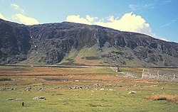
Although private vehicles are not permitted access to the lake itself, there is a carpark within walking distance, approx. half a mile from the dam and which is reached by road from the B5106 at Tal-y-bont, in the Conwy valley. The road passes through Llanbedr-y-Cennin and thereafter becomes a narrow lane as it goes over the hills towards the lake. Along this lane there are some public footpaths signposted, with stiles to access them over the old dry-stone walls that run along parts of the lane.

Bibliography

Related Research Articles

<span class="mw-page-title-main">Lake Vyrnwy</span> Man-made lake in Wales

Lake Vyrnwy is a reservoir in Powys, Wales, built in the 1880s for Liverpool Corporation Waterworks to supply Liverpool with fresh water. It flooded the head of the Vyrnwy valley and submerged the village of Llanwddyn.

<span class="mw-page-title-main">River Conwy</span> River in north Wales

The River Conwy is a river in north Wales. From its source to its discharge in Conwy Bay it is 55 kilometres (34 mi) long and drains an area of 678 square km. "Conwy" was formerly anglicised as "Conway."

<span class="mw-page-title-main">River Dwyryd</span> River in Gwynedd, Wales

The River Dwyryd, is a river in Gwynedd, Wales which flows principally westwards; draining to the sea into Tremadog Bay, south of Porthmadog.

<span class="mw-page-title-main">Llyn Brenig</span> Artificial lake in Cerrigydrudion, north Wales, UK

Llyn Brenig is a reservoir located on Denbigh Moors in North Wales. The artificial lake, which was constructed between 1973 and 1976, was created by building an embankment dam across the Afon Brenig valley. It lies at 1,200 ft (370 m) above sea level on the border between the counties of Conwy and Denbighshire. It is used to manage the flow in the River Dee as part of the River Dee regulation system.

<span class="mw-page-title-main">Llyn Cowlyd</span> Natural lake, reservoir in Snowdonia National Park, Wales

Llyn Cowlyd is the deepest lake in northern Wales. It lies in the Snowdonia National Park at the upper end of Cwm Cowlyd on the south-eastern edge of the Carneddau range of mountains, at a height of 330 metres (1,083 ft) above sea level. The lake is long and narrow, measuring nearly 3 kilometres (2 mi) long and about 500 m wide, and covers an area of 1.1 square kilometres. It has a mean depth of 33 metres (108 ft) and at its deepest has given soundings of 70 metres (230 ft), this being some 14 m (46 ft) greater than its natural depth, the water surface having been raised twice by the building of dams.

<span class="mw-page-title-main">Llyn Crafnant</span> Natural lake in North Wales

Llyn Crafnant is a lake that lies in a valley in Wales where the northern edge of the Gwydir Forest meets the lower slopes of the Carneddau mountains and, more specifically, the ridge of Cefn Cyfarwydd. The head of the valley offers a profile of crags which are silhouetted at sunset. The Forest Park guide (2002) states that "the is one of the most breathtaking views in all Snowdonia". The summits include Crimpiau 475 metres, and Craig Wen 548 metres which provide views to Moel Siabod and the Ogwen Valley, and Snowdon. Further up is Creigiau Gleision. At 63 acres (250,000 m2) it is the best part of a mile long, although it was clearly once much longer - its southern end shows the evidence of centuries of silting. Jehu's survey (see references) recorded a maximum depth of 71 ft (22 m).

<span class="mw-page-title-main">Llyn Geirionydd</span> Lake in Snowdonia, Wales

Llyn Geirionydd lies in a valley in North Wales where the northern edge of the Gwydyr Forest meets the lower slopes of the Carneddau mountains. The lake is almost a mile long and covers an area of 45 acres (180,000 m2), but is never any deeper than 50 ft (15 m) according to Jehu's survey. The lake can be reached by car from Trefriw or Llanrwst in the Conwy valley, the lane passing through the hamlet of Llanrhychwyn, or from the road through the Gwydir Forest. Access is not particularly easy by either route, but this has not stopped the lake being the only one designated in Snowdonia to permit power boats and water skiing. Many visitors also walk to the lake from the village of Trefriw or from the neighbouring lake of Llyn Crafnant, which runs parallel to it, but a mile distant, the two being separated by Mynydd Deulyn, “mountain of the two lakes”.

<span class="mw-page-title-main">Dolgarrog</span> Village and community in Conwy County Borough, Wales

Dolgarrog is a village and community in Conwy County Borough, in Wales, situated between Llanrwst and Conwy, very close to the Conwy River. The village is well known for its industrial history since the 18th century and the Eigiau dam disaster, which occurred in 1925. The population was 414 at the 2001 Census, increasing to 446 at the 2011 Census. The community extends up to, and includes part of, Llyn Cowlyd in the Carneddau.

<span class="mw-page-title-main">Llyn Dulyn</span> Natural lake, reservoir in Snowdonia, North Wales

Llyn Dulyn is a lake on the edge of the Carneddau range of mountains in Snowdonia, North Wales. The lake is 33 acres (130,000 m2) in extent and 189 feet deep. Less than a kilometre to its south lies the smaller Llyn Melynllyn. Cliffs rise steeply from the lake edge up to the summits of Garnedd Uchaf and Foel Grach, giving it a dark brooding appearance - hence its name.

<span class="mw-page-title-main">Llyn Conwy</span> Welsh lake near Cwm Penmachno in central Snowdonia

Llyn Conwy (SH780462) is a lake in the county of Conwy in central north Wales. It is the source of the River Conwy which, on flowing south out of the lake, swings round to then generally flow in a northerly direction for a distance of some 27 miles (43 km) to its discharge in Conwy Bay. Llyn Conwy lies at a height of about 1,488 ft, with a maximum depth of 16 feet, and is by far the biggest lake of the Migneint moors, an extensive area of blanket mire with high rainfall - about 260 cm p.a. There is a view of Arenig Fawr.

Afon Ddu is the name of several rivers in Snowdonia in north-west Wales:

<span class="mw-page-title-main">Afon Porth-llwyd</span> River in Snowdonia in north-west Wales

Afon Porth-llwyd is a river in Snowdonia in north-west Wales. It flows from Llyn Eigiau on the south-eastern edge of the Carneddau range to join the river Conwy.

<span class="mw-page-title-main">Coedty Reservoir</span> Reservoir in Snowdonia, North Wales

Coedty Reservoir is a reservoir in Snowdonia, North Wales. It is fed by the waters of Afon Porth-llwyd which flows from Llyn Eigiau. The reservoir lies at a height of 900 feet (274 m), and measures some 12 acres (49,000 m2) in size. It contains brown trout.

<span class="mw-page-title-main">Afon Dulyn</span> Outflow from Llyn Dulyn, a lake in the Carneddau mountains in north-west Wales

Afon Dulyn is the outflow from Llyn Dulyn, a lake in the Carneddau mountains in north-west Wales. It is a tributary of the river Conwy.

<span class="mw-page-title-main">Ffynnon Llugwy</span> Natural, reservoir in Snowdonia, North Wales

Ffynnon Llugwy is a lake in the Carneddau range of mountains in Snowdonia, North Wales.

<span class="mw-page-title-main">Eigiau Tramway</span>

The Eigiau Tramway might refer to the Eigiau Quarry Tramway or to the Eigiau Reservoir Tramway.

<span class="mw-page-title-main">Cowlyd Tramway</span> Railway line in northern Wales

The Cowlyd Tramway was a 2 ft narrow gauge railway line used to convey men and materials to Llyn Cowlyd Reservoir, near Trefriw in northern Wales during the enlargement of the dam, and thereafter for maintenance purposes.

The Cedryn Quarry Tramway was an industrial narrow gauge railway that connected the slate quarries at Cedryn and Cwm Eigiau to the quays at Dolgarrog in the Conwy valley.

<span class="mw-page-title-main">Cefn Cyfarwydd</span> Hill in Conwy County Borough, Wales

Cefn Cyfarwydd is a ridge in Conwy county borough, north Wales. It is located above the village of Trefriw on the western side of the Conwy valley, and dramatically separates Cwm Cowlyd and the rugged mountains of the Carneddau from the greener, lusher Conwy valley.

<span class="mw-page-title-main">Dolgarrog power station</span> Power station in Wales

Dolgarrog Power Station in Dolgarrog, Wales was originally built in 1907 as part of an aluminium smelting plant. It uses water turbines to drive electricity alternators. Public supplies began in 1922 when power lines were constructed to transmit electricity from the power station to Colwyn Bay, Conwy and Llandudno. The station was vested in the British Electricity Authority and its successors following nationalisation in 1948. It is currently (2021) operated by RWE NPower UK.

References

  1. "Film: 'Nov. 2nd 1925. The Dolgarrog Disaster' (1925)". Gathering the Jewels. he National Library of Wales. Archived from the original on 22 February 2012.