The Kennet is a tributary of the River Thames in Southern England. Most of the river is straddled by the North Wessex Downs AONB. The lower reaches have been made navigable as the Kennet Navigation, which – together with the Avon Navigation, the Kennet and Avon Canal and the Thames – links the cities of Bristol and London.

The River Rother, a waterway in the northern midlands of England, gives its name to the town of Rotherham and to the Rother Valley parliamentary constituency. It rises in Pilsley in Derbyshire and flows in a generally northwards direction through the centre of Chesterfield, where it feeds the Chesterfield Canal, and on through the Rother Valley Country Park and several districts of Sheffield before joining the River Don at Rotherham in Yorkshire. Historically, it powered mills, mainly corn or flour mills, but most had ceased to operate by the early 20th century, and few of the mill buildings survive.

The River Blackwater is a tributary of the Loddon in England and sub-tributary of the Thames. It rises at two springs in Rowhill Nature Reserve between Aldershot, Hampshire and Farnham, Surrey. It curves a course north then west to join the Loddon in Swallowfield civil parish, central Berkshire. Part of the river splits Hampshire from Surrey; a smaller part does so as to Hampshire and Berkshire.

The River Poulter which rises near Scarcliffe in Derbyshire, England is a tributary river of the River Idle in Nottinghamshire. It supplied power to mills along its route, most of which are now gone, although their mill ponds remain. Cuckney mill building is used as a primary school. The river has been dammed to create several lakes in the Dukeries estates of Welbeck Abbey and Clumber House now the National Trust property of Clumber Park. The ornamental Gouldsmeadow Lake, Shrubbery Lake and Great Lake on the Welbeck estate are supplied by a tributary of the Poulter, while Carburton Forge Dam and Carburton Dam were built to power a forge and a mill. Clumber Lake, consisting of an upper and lower lake, which is spanned by a Grade II* listed ornamental bridge, is part of the Clumber estate, and has suffered from subsidence.

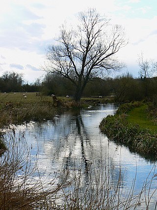
Foudry Brook is a small stream in southern England. It rises from a number of springs near the Hampshire village of Baughurst, and flows to the east and then the north, to join the River Kennet to the south of Reading. The upper section is called Silchester Brook, and beyond that, Bishop's Wood Stream. The underlying geology is chalk, covered by a layer of clay, and so it has the characteristics of a clay stream, experiencing rapid increases in level after heavy rain due to run-off from the surrounding land. It passes a number of listed buildings and scheduled monuments, including the site of the Roman town of Calleva Atrebatum or Silchester.

The Little Don River also known as the Porter, is a tributary of the River Don in South Yorkshire, England. Arising on the Langsett Moors in the northern Peak District, the Little Don River feeds the Langsett and Underbank Reservoirs. It runs through the town of Stocksbridge before joining the River Don.

The River Perry is a river in Shropshire, England. It rises near Oswestry and flows south to meet the River Severn above Shrewsbury. Along its 24 miles (39 km) length, its level drops by some 320 feet (95 m). The channel has been heavily engineered, both to enable water mills to be powered by it, and to improve the drainage of the surrounding land. There were at least seven corn mills in the 1880s, and the last one remained operational until 1966. The middle section of the river crosses Baggy Moor, where major improvements were made in 1777 to drain the moor. The scheme was one of the largest to enclose and improve land in North Shropshire, and the quality of the reclaimed land justified the high cost. A section of the river bed was lowered in the 1980s, to continue the process.

Stratfield Mortimer is a village and civil parish, just south of Reading, in the English county of Berkshire and unitary authority area of West Berkshire.
Burghfield is a village and large civil parish in West Berkshire, England, with a boundary with Reading. Burghfield can trace its history back to before the Domesday book, and was once home to three manors: Burghfield Regis, Burghfield Abbas and Sheffield. Since the 1980s the population of Burghfield has nearly doubled with the construction of many new housing estates, making it a dormitory for Reading, Newbury, Basingstoke and the M4 corridor which crosses the north of the parish.

Wokefield is a hamlet and civil parish in the West Berkshire district of Berkshire, England, south of Reading. The parish includes the hamlets of Goddard's Green and Bloomfield Hatch. It also includes part of the former parish of Sulhamstead and Grazeley.

The Blackburn Brook is a stream in Sheffield, South Yorkshire, England which flows through the Blackburn Valley along the M1 and Ecclesfield Road and joins the River Don near the Meadowhall shopping centre. Downstream from the A61 road at Chapeltown the Blackburn Brook is defined as a main river by the Environment Agency, which requires new building development to be at least 26 feet (8 m) from the bank side as a flood defence measure and to allow access to the watercourse for maintenance.

Cove Brook runs 4 miles (6.4 km) from near Farnborough Airport in Farnborough, Hampshire, England and flows through the former Southwood Golf Course where it is joined by Marrow Brook and other smaller streams. It runs north through Cove before joining the Blackwater at Hawley Meadows near the M3 motorway.

The River Hipper is a tributary of the River Rother in Derbyshire, England. Its source is a large expanse of wetlands, fed by the surrounding moors between Chatsworth and Chesterfield, known as the Hipper Sick on Beeley Moor, which is part of the Chatsworth Estate. It then passes through Holymoorside and down into Chesterfield, just south of the town centre, before flowing into the River Rother. In July 2007, parts of Chesterfield flooded when the River Hipper burst its banks during a substantial storm that caused extensive flooding in North Derbyshire and South Yorkshire. The surrounding landscape is known as the Hipper Valley.
The Cut is a river in England that rises in North Ascot, Berkshire. It flows for around 14 miles (23 km), through the rural Northern Parishes of Winkfield, Warfield and Binfield in Bracknell Forest on its way down to Bray, where it meets the River Thames just above Queens Eyot on the reach below Bray Lock, having been joined by the Maidenhead Waterways.

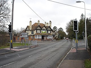
Burghfield Brook is a small stream in southern England. It rises in Wokefield Common between the Berkshire villages of Mortimer and Burghfield Common. It is a tributary of Foudry Brook, which it joins near Hartley Court Farm, just to the south of the M4 motorway.

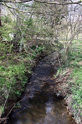
Clayhill Brook is a small stream in southern England, in the county of Berkshire.

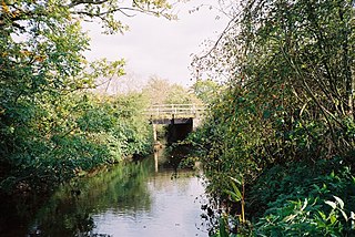
West End Brook is a small stream in southern England. It rises near the Hampshire village of Tadley. Its name is probably related to the parish, and village, it passes through for some of its course: Mortimer West End.

The River Hart is a tributary of the River Whitewater in north Hampshire, England. It rises at Ashley Head spring in Crondall and flows north to meet the Whitewater at Bramshill.

Fleet Brook is a small river in northern Hampshire, England and tributary of the River Hart.
Barkham Brook is a small river in the English county of Berkshire. It has sources to the north and west of Finchampstead in the Wokingham Borough, flows past the village of Barkham, and joins the River Loddon to the west of Winnersh.