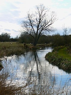
The Kennet is a tributary of the River Thames in Southern England. Most of the river is straddled by the North Wessex Downs AONB. The lower reaches have been made navigable as the Kennet Navigation, which – together with the Avon Navigation, the Kennet and Avon Canal and the Thames – links the cities of Bristol and London.

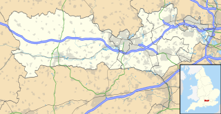
West Berkshire is a local government district in Berkshire, England, administered from Newbury by West Berkshire Council.

Aldermaston is a village and civil parish in Berkshire, England. In the 2011 United Kingdom census, the parish had a population of 1015. The village is in the Kennet Valley, and bounds Hampshire to the south. It is roughly equidistant from Newbury, Basingstoke and Reading, and is 46 miles (74 km) west-by-south-west of London.

East Woodhay is a village and civil parish in Hampshire, England, situated approximately 6 miles (10 km) south-west of Newbury in Berkshire. As of the 2001 census, it had a population of 2,794, increasing to 2,914 at the 2011 Census.

Wash Common is a small suburb to the south of Newbury, Berkshire. It is built on the former Newbury Wash, which was flat open heathland overlooking Newbury, and until the 19th century there was just a small group of houses separated from Newbury by open country. Both places have grown into each other, and the suburb of Wash Common is now contiguous with Newbury. Most housing development has taken place to the west of the Andover road, and some of the area to the east of the road still remains open farmland.
Hell Corner is a hamlet in the civil parish of Inkpen in the English county of Berkshire. It is situated in the West Berkshire district, south of the River Kennet, between Newbury and Hungerford and close to the Hampshire border. Although wholly within Inkpen, it lies right on the border with Kintbury and West Woodhay and adjoins Inkpen Common. Inkpen Great Common is a Site of Special Scientific Interest between Hell Corner and Inkpen Common. It is managed by the Berkshire, Buckinghamshire and Oxfordshire Wildlife Trust.

Enborne is a village and civil parish, in West Berkshire, England that bounds to the east, across a road buffer Newbury. The River Enborne shares its name, although it does not run through the village; rather, it runs through and rises near the nearby village of Enborne Row. Enborne is a civil and an ecclesiastical parish in the ceremonial and historic county of Berkshire. It lost some of its eastern land to Newbury's 20th century expansion. The village name has had many variant spellings in the past, including Anebourne in 1086, and Enbourne, Enborn, Enbourn in the last 200 years.

Aldermaston Wharf is a small multi-parish settlement centred 1.5 miles (2.4 km) north-northwest of Aldermaston in West Berkshire, England. The Kennet and Avon Canal passes through the settlement with Aldermaston Lock near the centre while the Great Western Railway passes at the northern side where Aldermaston railway station is also located. The A340 road from Basingstoke passes through the village crossing the canal over a single file lift bridge and joins the A4 road which runs just north of the village.

Brimpton is a mostly rural village and civil parish in West Berkshire, England. The village occupies a few square miles of land between the Kennet and Avon Canal, a long tributary the Enborne which is used as part of the Hampshire boundary and the winding slopes of an escarpment in the far south-east, beyond the Enborne which is almost contiguous with the larger settlement of Baughurst a wood-buffered part of Tadley post town. This high common field contains five round barrows from the period of the Heptarchy in Anglo Saxon England.

West Woodhay is a rural scattered village and civil parish in West Berkshire, England. At the 2011 census it had 59 households.

Newtown is a village and civil parish in the English county of Hampshire, about 1+1⁄2 miles (2.4 km) south of Newbury, Berkshire.
Brimpton Common is a village in Berkshire, England. It is part of Brimpton Parish, and part of the Benefice of Aldermaston and Woolhampton in the Diocese of Oxford. It is in the Aldermaston Ward of West Berkshire Council.

Wash Water is a hamlet on the border of Berkshire, and Hampshire. It is divided between the civil parishes of Enborne, Newbury, Highclere and East Woodhay. The settlement lies adjacent to the A343 and A34 highways, approximately 3 miles (4.8 km) south-south-west of Newbury.
Sandleford is a hamlet and former parish in the English county of Berkshire. Since at least 1924, the settlement has been within the civil parish of Greenham, and is located approximately 1.5 miles (2.4 km) south of the town of Newbury.
The Berks and Hants Canal, incorporated as the Berkshire and Hampshire Junction Canal Company, was a proposed canal in the English counties of Berkshire and Hampshire. Proposals for the waterway originate after the completion of the Kennet and Avon Canal and the Basingstoke Canal in the 1790s, with a view to connecting the two canals.
Sandleford Priory was a small Augustinian Priory, the remains of which now stand at Sandleford in the civil parish of Greenham in the English county of Berkshire.

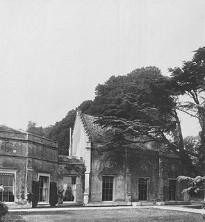
Sandleford Priory is a largely 18th century country house at Sandleford in the civil parish of Greenham in the English county of Berkshire. It incorporates the chapel of a former monastery and is currently the home of St Gabriel's School.


