
Basingwerk Abbey is a Grade I listed ruined abbey near Holywell, Flintshire, Wales. The abbey, which was founded in the 12th century, belonged to the Order of Cistercians. It maintained significant lands in the English county of Derbyshire. The abbey was abandoned and its assets sold following the Dissolution of the Monasteries in 1536.

Offa's Dyke Path is a long-distance footpath broadly following the Wales–England border. Officially opened on 10 July 1971, by Lord Hunt, it is one of Britain's National Trails and draws walkers from throughout the world. About 60 miles (97 km) of the 177-mile (285 km) route either follows, or keeps close company with, the remnants of Offa's Dyke, an earthwork, most of which was probably constructed in the late 8th century on the orders of King Offa of Mercia.
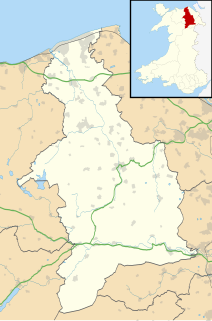
Denbighshire is a county in north-east Wales. Its borders differ from the eponymous historic county. This part of Wales contains the country's oldest known evidence of habitation – Pontnewydd (Bontnewydd-Llanelwy) Palaeolithic site has Neanderthal remains of some 225,000 years ago. Castles include Denbigh, Rhuddlan, Ruthin, Castell Dinas Bran and Bodelwyddan. St Asaph, one of Britain's smallest cities, has one of its smallest Anglican cathedrals. Denbighshire is bounded by coastline to the north and hills to the east, south and west. The River Clwyd follows a broad valley with little industry: crops appear in the Vale of Clwyd and cattle and sheep in the uplands. The coast attracts summer visitors; hikers frequent the Clwydian Range, part of an Area of Outstanding Natural Beauty with the upper Dee Valley. Llangollen International Musical Eisteddfod takes place each July.

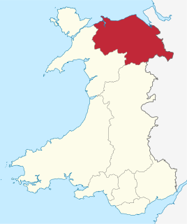
Flintshire is a county in north-east Wales. It borders the English county of Cheshire to the east, Denbighshire to the west and Wrexham County Borough to the south. It is named after the historic county of Flintshire which has notably different borders. Flintshire is considered part of the Welsh Marches and formed part of the historic Earldom of Chester and Flint. The county is governed by Flintshire County Council which has its main offices in County Hall, Mold.
Flintshire, also known as the County of Flint, is one of Wales' thirteen historic counties, and a former administrative county. It mostly lies on the north-east coast of Wales.
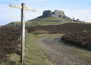
Moel Famau is the highest hill in the Clwydian Range and the highest point of the county of Flintshire in Wales. It lies on the boundary between Denbighshire and Flintshire. The hill, which also gives its name to the Moel Famau country park, has been classed as an Area of Outstanding Natural Beauty since 1985. It is also surrounded by several well-preserved Iron Age hill forts. It is not, as many people think, the highest peak in North-East Wales; this honour goes to Cadair Berwyn. It is also the third-highest peak in the extended AONB of the Clwydian Range and Dee Valley.
Clwyd is a preserved county of Wales, situated in the north-east corner of the country; it is named after the River Clwyd, which runs through the area. To the north lies the Irish Sea, with the English ceremonial counties of Cheshire to the east and Shropshire to the south-east. Powys and Gwynedd lie to the south and west respectively. Clwyd also shares a maritime boundary with Merseyside along the River Dee. Between 1974 and 1996, a slightly different area had a county council, with local government functions shared with six district councils. In 1996, Clwyd was abolished, and the new unitary authorities of Wrexham, Conwy County Borough, Denbighshire, and Flintshire were created; under this reorganisation, "Clwyd" became a preserved county, with the name being retained for certain ceremonial functions.

The River Dee is a river in the United Kingdom. It flows through parts of both Wales and England, forming part of the border between the two countries.

Loggerheads is a village in Denbighshire, Wales on the River Alyn, a tributary of the River Dee.

The Clwydian Range is a series of hills in north east Wales that runs from Llandegla in the south to Prestatyn in the north, with the highest point being the popular Moel Famau. The range forms part of the Clwydian Range and Dee Valley Area of Outstanding Natural Beauty.

The River Alyn is a tributary of the River Dee. The River Alyn rises at the southern end of the Clwydian hills and the Alyn Valley forms part of the Clwydian Range and Dee Valley Area of Outstanding Natural Beauty. The main town on the river Alyn is Mold, the county town of Flintshire. It lends its name to the constituencies of Alyn and Deeside in the UK Parliament and the Senedd.
The Alyn Gorge is a gorge section of the River Alyn north between Loggerheads and Rhydymwyn in Wales. The west side of the valley rises gently to Moel Famau, while the east bank is along parts a cliff with evidence of tram lines and old quarry workings.

Llanferres is a village and community in the county of Denbighshire in Wales. At the 2001 Census the population of the village was recorded as 676, increasing to 827 at the 2011 census.

Bwlch Penbarras is a mountain pass in the Clwydian Range and Dee Valley Area of Outstanding Natural Beauty, in north-east Wales. The gap, which is at an altitude of 360 m (1,180 ft), lies between the hills of Moel Famau and Foel Fenlli. An unclassified road between Tafarn-y-Gelyn and Llanbedr-Dyffryn-Clwyd runs from east to west through the pass. Offa's Dyke Path, running broadly south–north, crosses the road at its highest point.

Moel y Gaer is an Iron Age hillfort at the northern end of the Clwydian Range, located on a summit overlooking the valley of the River Wheeler, near the village of Bodfari, Denbighshire, Wales, five miles north-east of Denbigh. The site is a scheduled monument, classified as a prehistoric defensive hillfort.

Moel y Gaer, also known as Moel-y-Gaer Camp or Moel y Gaer Hillfort, is an Iron Age hillfort located on a western spur of the Clwydian Range, near the village of Llanbedr, Denbighshire, Wales. The site is a scheduled monument, classified as a prehistoric defensive hillfort.

Many parts of Wales are protected areas, according to a number of designations. They include three national parks, and five Areas of Outstanding Natural Beauty.

Aberwheeler is a village and community in the Welsh county of Denbighshire, located on the south bank of the River Wheeler, 4.2 miles (6.8 km) north east of Denbigh, 12.6 miles (20.3 km) north west of Mold and 11.0 miles (17.7 km) north of Ruthin. At the 2001 census the community had a population of 327, reducing to 298 at the 2011 census. The name has been Anglicised from the Welsh.

The Clwydian Range and Dee Valley is a designated Area of Outstanding Natural Beauty (AONB) and proposed national park, located in north-east Wales, covering the Clwydian Range, and the valley of the River Dee. Designated in 1985 as the Clwydian Range AONB, and expanded to its current form in 2011, the Area of Outstanding Natural Beauty includes: medieval field systems, open heather moorland, prehistoric hillforts, limestone crags, broad leaved woodland, wooded valleys, and farmland. In 2018, an estimated 1.1 million people visited six key sites across the AONB, generating approximately £24.1 million to the Welsh economy, according to Natural Resources Wales. The AONB falls within the jurisdiction of the local authorities of Denbighshire, Flintshire, and Wrexham County Borough, with the majority, 80% of the AONB in Denbighshire, and the remaining 20% split evenly between the other two authorities. The AONB is the largest of only five AONBs in Wales, and one of the 46 in the United Kingdom. Additionally, it is one of only 8 protected areas of Wales. Long-distance footpaths; Offa's Dyke Path, and the Clwydian Way pass through the AONB. The area of the Clwydian Range and Dee Valley AONB is 390 km2 (150 sq mi), and has been proposed by the Welsh Government to become Wales' fourth national park.


