Long Point, Iowa | |
|---|---|
 Long Point, Iowa | |
| Coordinates: 41°56′43″N92°29′02″W / 41.94528°N 92.48389°W | |
| Country | United States |
| State | Iowa |
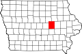
| County | Tama |
| Elevation | 804 ft (245 m) |
| Time zone | UTC-6 (Central (CST)) |
| • Summer (DST) | UTC-5 (CDT) |
| Area code | 641 |
| GNIS feature ID | 464627 [1] |
Long Point is an unincorporated community in Tama County, in the U.S. state of Iowa. [1]