Longford, Coventry

Last updated

Longford Road, Bedworth (looking south) Longford rd2 3u07.JPG
Longford Road, Bedworth (looking south)

Longford is a ward in the north of Coventry, West Midlands, England. The population of the Ward as taken at the 2011 census was 18,538. [1] It is covered by the Coventry North East constituency [2] and bounded by the wards of Holbrooks, Henley, Upper Stoke and Foleshill.

Contents

Features

The neighbourhoods covered by the ward include Longford Village, Foxford, Rowleys Green, Alderman's Green, Hawkesbury, Bell Green, Manor House, Hall Green, Courthouse Green, Woodshires and Little Heath. [3]

Longford is mainly residential, but it also has industrial areas and a few green areas, such as Longford Park and Longford Community Nature Park, which are in close proximity on opposite sides of Longford Road. In the north of the ward is the Coventry Building Society Arena, home to Wasps and Coventry City. Also part of the complex is Arena Park a Retail Centre including a Tesco Extra. Riley Square shopping centre is another shopping centre in the ward. Longford is also served by one library: Bell Green Library. [3]

Demographics

The 2001 UK Census found that there were 17,601 people living in Longford, with a population density of 37.3 per square kilometre; 738 people were students. 2011 Census data showed the population of Longford had increased to 18,538 people. [4] Longford has an area of 472 square kilometres. The number of people who were unemployed in Longford was 522 according to the Office for National Statistics in June 2006. 12,409 people were of a working age. The largest employer in the ward in 2004 was Henley College. [5] Henley College was formerly known as the Henley Campus of Coventry College. [6]

Education

Foxford Community School is the area's secondary school. Primary education is provided by Grangehurst Primary School.

History

The church of St Thomas the Apostle, Longford Road, Coventry St thomas the apostle church longford 30s07.JPG
The church of St Thomas the Apostle, Longford Road, Coventry

The area is referred to as early as the 15th century, stating that there were houses and cottages in the areas of Longford and Foxford however these had not developed to form hamlets. A census in 1730 stated that there were only 20 houses in Longford and Foxford. Longford began to develop in the mid-18th century when the ribbon weaving industry and a flourishing coal mine at Hawkesbury encouraged workers and their families to move into Longford.

Historically Longford was part of Bedworth, under the parish of Exhall. [7] During this period Thomas Mann, an English trade unionist and the First World War pacifist was born here. Longford was and still is on the main route from the mining districts of Nuneaton and Bedworth to Coventry. Longford at present is a suburb of Coventry.

Canals

Coventry canal, the towpath, and one of bridges on Longford Road in Longford. Bridge canal longford 3u07.JPG
Coventry canal, the towpath, and one of bridges on Longford Road in Longford.

The Coventry Canal passes through the area. On the towpath is a sculpture named 'The Stone Sofa', by Tim Shutter. Unveiled on 31 May 1997, it was commissioned by Groundwork Coventry as part of the Coventry Canal Art Trail, and is owned by the City Development Directorate at Coventry City Council. The sculpture is 1.4 metres high, 2.4 metres wide and approximately one metre deep and carved out of solid sandstone. [8] [9]

The Oxford Canal was started in the area in 1769 and the first 10 miles were completed by 1771. The two canals passed alongside each other from Hawkesbury to Longford as the Coventry Canal Company and the Oxford Canal Company were unable to agree on tolls. Following a court injunction taken out by the Coventry Canal Company, the two canals were joined at Longford in 1777. [10] The current junction of the canals is Hawkesbury Junction.

Related Research Articles

<span class="mw-page-title-main">Coventry</span> City in the West Midlands, England

Coventry is a city in the West Midlands, England. It is on the River Sherbourne. Coventry has been a large settlement for centuries, although it was not founded and given its city status until the Middle Ages. The city is governed by Coventry City Council.

<span class="mw-page-title-main">Oxford Canal</span> Canal in England

The Oxford Canal is a 78-mile (126 km) narrowboat canal in central England linking the City of Oxford with the Coventry Canal at Hawkesbury via Banbury and Rugby. Completed in 1790, it connects to the River Thames at Oxford, and links with the Grand Union Canal, which it is combined with for 5 miles (8 km) between to the villages of Braunston and Napton-on-the-Hill.

<span class="mw-page-title-main">Nuneaton</span> Market town in Warwickshire, England

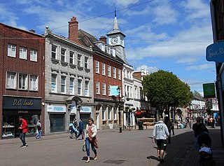
Nuneaton is a market town in the Borough of Nuneaton and Bedworth in northern Warwickshire, England, close to the county border with Leicestershire and West Midlands County. The population in 2020 was estimated at 91,334, making it the largest town in Warwickshire.

<span class="mw-page-title-main">Bedworth</span> Human settlement in England

Bedworth is a market town in the borough of Nuneaton and Bedworth, Warwickshire, England. It is situated between Coventry, 6 miles to the south, and Nuneaton, 3 miles (5 km) to the north.

<span class="mw-page-title-main">Coventry Canal</span> Canal in Staffordshire, England

The Coventry Canal is a navigable narrow canal in the Midlands of England.

<span class="mw-page-title-main">Nuneaton and Bedworth</span> Borough & Non-metropolitan district in England

Nuneaton and Bedworth is a local government district with borough status, in northern Warwickshire, England, consisting of the towns of Nuneaton and Bedworth, the large village of Bulkington and the green belt land inbetween. It had a population of 129,883 at a 2019-estimate.

<span class="mw-page-title-main">Warwickshire</span> County of England

Warwickshire is a county in the West Midlands region of England. The county town is Warwick, and the largest town is Nuneaton. The county is famous for being the birthplace of William Shakespeare at Stratford-upon-Avon and Victorian novelist George Eliot,, at Nuneaton. Other significant towns include Rugby, Leamington Spa, Bedworth, Kenilworth and Atherstone. The county offers a mix of historic towns and large rural areas. It is a popular destination for international and domestic tourists to explore both medieval and more recent history.

<span class="mw-page-title-main">North Warwickshire</span> Borough & Non-metropolitan district in England

North Warwickshire is a local government district with borough status in the ceremonial county of Warwickshire, West Midlands, England. Outlying settlements in the borough include the two towns of Atherstone and Coleshill. Notable villages in the borough include Dordon, Polesworth, Kingsbury, Water Orton and Shustoke.

<span class="mw-page-title-main">Warwickshire ring</span>

The Warwickshire ring is a connected series of canals forming a circuit around the West Midlands area of England. The ring is formed from the Coventry Canal, the Oxford Canal, the Grand Union Canal, the Stratford-upon-Avon Canal and the Birmingham and Fazeley Canal. It is a popular route with tourists due to its circular route and mixture of urban and rural landscapes.

<span class="mw-page-title-main">Coventry–Nuneaton line</span>

The Coventry to Nuneaton Line is a railway line linking Coventry and Nuneaton in the West Midlands of England. The line has a passenger service. It is also used by through freight trains, and freight trains serving facilities on the route.

Keresley is a suburban village and civil parish in the City of Coventry, West Midlands, England, about 4.5 miles (7 km) north of Coventry city centre and 3.5 miles (6 km) southwest of Bedworth. According to the 2001 census, the parish had a population of 791 falling to 713 at the 2011 Census, although the 2018 population was estimated at 783. Keresley and Keresley End are two separate areas; Keresley is in Coventry, while the slightly more rural Keresley End, also known as Keresley village or Keresley Newlands, is in Warwickshire, with the exception of Thompsons Road in the village, which lies within the Coventry boundary. The village features two grocers shops, two bus stops, a beauty salon, primary school, doctors surgery, a fish and chip shop, a small church, a post office, library, park, garden centre and community centre.

<span class="mw-page-title-main">River Sowe</span> River in Warwickshire and the West Midlands, England

The River Sowe is a river in Warwickshire and West Midlands, England. It is a tributary of the River Avon, and flows into it just south of Stoneleigh about 5 miles (8 km) south of Coventry. It is about 12 miles (19 km) long.

Exhall is a suburban settlement in the Nuneaton and Bedworth district of Warwickshire, England.

Hawkesbury Village is a settlement in the Nuneaton and Bedworth district of Warwickshire, central England.

Hawkesbury Junction

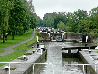
Hawkesbury Junction or Sutton Stop is a canal junction in England, at the northern limit of the Oxford Canal where it meets the Coventry Canal, near Hawkesbury Village, Warwickshire, between Bedworth and Coventry. The alternative name, Sutton Stop, arises from the name of a family which provided several lock keepers there in the nineteenth century.

<span class="mw-page-title-main">Arena Park Shopping Centre</span> Shopping mall in Coventry, United Kingdom

Arena Park Shopping Centre is a shopping park in Coventry, England. It is located in the north of the city and adjacent to the boundary with the Nuneaton and Bedworth district of Warwickshire. It was constructed at the same time as the neighbouring Coventry Building Society Arena, from which it takes its name. It was built upon the site of the former Foleshill Gasworks which encompassed the area of the Shopping Centre and the arena. It is owned by Tesco Stores Limited. It is sometimes mistakenly referred to as Arena Shopping Park.

The two Coventry power stations supplied electricity to the county borough of Coventry and the wider Warwickshire area from 1895 to 1976. They were owned and operated by Coventry Corporation until the nationalisation of the British electricity supply industry in 1948. The first power station was established in 1895 off Sandy Lane north of the city centre. A new larger power station was built at Longford / Hawksbury Junction in 1928 and was extended in 1938 and 1941. The Longford station was decommissioned in October 1976.

<span class="mw-page-title-main">2021 Nuneaton and Bedworth Borough Council election</span>

The 2021 Nuneaton and Bedworth Borough Council election was held on 6 May 2021 as part of the 2021 United Kingdom local elections and alongside elections for Warwickshire County Council and Warwickshire Police and Crime Commissioner. Half of the borough council seats were up for election and the results provided the Conservative Party with a majority on the council, with the party winning all but two seats up for election.

<span class="mw-page-title-main">2022 Nuneaton and Bedworth Borough Council election</span>

The 2022 Nuneaton and Bedworth Borough Council election was held on 5 May 2022 to elect members of Nuneaton and Bedworth Borough Council. Seventeen seats of the thirty-four seats on the council were elected, as part of the wider 2022 local elections.

References

  1. "Coventry Ward population 2011". Neighbourhood Statistics. Office for National Statistics. Retrieved 17 December 2015.
  2. "Coventry City Council: Longford Ward". Archived from the original on 27 September 2007. Retrieved 2 September 2007.
  3. 1 2 Coventry City Council: About Longford Ward Archived 27 September 2007 at the Wayback Machine
  4. Services, Good Stuff IT. "Longford - UK Census Data 2011". UK Census Data. Retrieved 16 November 2020.
  5. Coventry City Council: Longford in numbers Archived 27 September 2007 at the Wayback Machine
  6. "Coventry College • Where you get inspired". Coventry College. Retrieved 16 November 2020.
  7. "History of Longford, in Coventry and Warwickshire | Map and description". www.visionofbritain.org.uk. Retrieved 16 November 2020.
  8. George Thomas Noszlopy (2003). Public Sculpture of Warwickshire, Coventry and Solihull. Liverpool University Press. pp. 133–134. ISBN   0-85323-847-2.
  9. Coventry Canal Sculpture Trail Archived 3 October 2011 at the Wayback Machine
  10. Coventry Walks: Hawkesbury Junction Conservation Area

Coordinates: 52°27′07″N1°29′10″W / 52.452°N 1.486°W / 52.452; -1.486