
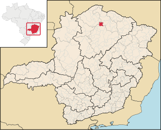
Lontra is a municipality in the north of the Brazilian state of Minas Gerais. As of 2020, the population was 9,714 in a total area of 257 km². [1] It became a municipality in 1993.
Lontra is a municipality in the north of the Brazilian state of Minas Gerais. As of 2020, the population was 9,714 in a total area of 257 km². [1] It became a municipality in 1993.
Lontra is located at an elevation of 781 meters, 35 km. south of the São Francisco River. It is on highway BR-135, which connects Montes Claros to Januária. It belongs to the statistical microregion of Montes Claros. Neighboring municipalities are Japonvar, São João da Ponte, Ibiracatu, and Januária.
The most important economic activities are cattle raising, commerce, and subsistence agriculture. The gross domestic product in 2005 was R$ 18,047,000. Lontra is in the bottom tier of municipalities in the state with regard to economic and social development. It suffers from isolation, poor soils, and periodic drought. As of 2007, there were no banking agencies in the town. There was a small retail commerce serving the surrounding area of cattle and agricultural lands. In the rural area there were 304 establishments employing about 1,300 workers. Only five of the farms had tractors. There were 115 automobiles in all of the municipality. There were 8,500 head of cattle in 2006. The crops with a planted area of more than 50 hectares were beans, sugarcane and corn. [2]
In the health sector there were four clinics and no hospitals. In the educational sector there were eight primary schools and one middle school. [2]
The highest ranking municipality in Minas Gerais in 2000 was Poços de Caldas with 0.841, while the lowest was Setubinha with 0.568. Nationally the highest was São Caetano do Sul in São Paulo with 0.919, while the lowest was Setubinha. [4]

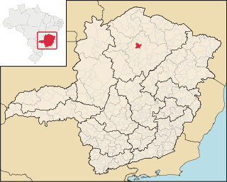
Ubaí is a municipality in the north of the Brazilian state of Minas Gerais. As of 2020 the population was 12,599 in a total area of 821 km2. It became a municipality in 1962.
Varzelândia is a municipality in the north of the Brazilian state of Minas Gerais. As of 2020 the population was 19,305 in a total area of 804 km². It became a municipality in 1962.

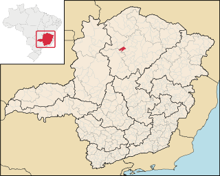
São João da Ponte is a municipality in the north of the Brazilian state of Minas Gerais. As of 2020, the population numbered 25,098 within the total area of 1,849 km². The elevation is 561 meters. It became a municipality in 1943.

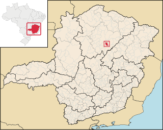
Juramento is a municipality in the north of the Brazilian state of Minas Gerais. As of 2020 the population was 4,345 in a total area of 432 km2. It became a municipality in 1953.

Jequitaí is a Brazilian municipality located in the north of the state of Minas Gerais. In 2020 the population was 7,468 in a total area of 1,268 km2. It became a municipality in 1948.
Campo Azul is a Brazilian municipality located in the north of the state of Minas Gerais. In 2020 the population was 3,824 in a total area of 506 km². It became a municipality in 1995.

Claro dos Poções is a Brazilian municipality located in the north of the state of Minas Gerais. In 2020 the population was 7,514 in a total area of 706 km². It became a municipality in 1962.

Coração de Jesus is a Brazilian municipality located in the north of the state of Minas Gerais. In 2020 the population was 26,611 in a total area of 2,236 km2. It became a municipality in 1912.

Glacilândia is a Brazilian municipality located in the north of the state of Minas Gerais. In 2020 the population was 3,164 in a total area of 145 km2. It became a municipality in 1996.

Ibiracatu is a Brazilian municipality located in the north of the state of Minas Gerais. In 2020 the population was 5,369 in a total area of 359 km2. It became a municipality in 1995.

Japonvar is a Brazilian municipality located in the north of the state of Minas Gerais. In 2020 the population was 7,982 in a total area of 376 km². It became a municipality in 1997.

Luislândia is a municipality in the north of the Brazilian state of Minas Gerais. As of 2020 the population was 6,718 in a total area of 425 square kilometres (164 sq mi). It became a municipality in 1997.
Mirabela is a municipality in the north of the Brazilian state of Minas Gerais. As of 2020 the population was 13,620 in a total area of 721 km2. It became a municipality in 1962.

Patis is a municipality in the north of the Brazilian state of Minas Gerais. As of 2010 the population was 5,579 in a total area of 444 km2. It became a municipality in 1995.

Ponto Chique is a municipality in the north of the Brazilian state of Minas Gerais. As of 2020, the population was 4,283 in a total area of 602 km2. It became a municipality in 1997.

São João da Lagoa is a municipality in the north of the Brazilian state of Minas Gerais. As of 2020 the population was 4,932 in a total area of 990 km2. It became a municipality in 1995.

São João do Pacuí is a municipality in the north of the Brazilian state of Minas Gerais. As of 2020 the population was 4,448 in a total area of 420 km2. It became a municipality in 1997.

Verdelândia is a municipality in the north of the Brazilian state of Minas Gerais. As of 2020 the population was 9,443 in a total area of 1,452 km². It became a municipality in 1997.

Francisco Dumont is a Brazilian municipality located in the north of the state of Minas Gerais. Its population as of 2020 was 5,242 people living in a total area of 1,553 km². The city belongs to the mesoregion of North of Minas and to the microregion of Bocaiúva. It became a municipality in 1962.
Guaraciama is a Brazilian municipality located in the north of the state of Minas Gerais. Its population as of 2020 was 4,989 people living in a total area of 392 km2. The city belongs to the mesoregion of North of Minas and to the microregion of Bocaiúva. It became a municipality in 1997.