The West Branch Delaware River is one of two branches that form the Delaware River. It is approximately 90 mi (144 km) long, and flows through the U.S. states of New York and Pennsylvania. It winds through a mountainous area of New York in the western Catskill Mountains for most of its course, before joining the East Branch along the northeast border of Pennsylvania with New York. Midway or so it is empounded by the Cannonsville Dam to form the Cannonsville Reservoir, both part of the New York City water supply system for delivering drinking water to the City.

Lake Tear of the Clouds is a small tarn located in the town of Keene, in Essex County, New York, United States, on the southwest slope of Mount Marcy, the state's highest point, in the Adirondack Mountains. It is the highest pond in the state. It is often cited as the highest source of the Hudson River, via Feldspar Brook, the Opalescent River and Calamity Brook.

Coronation Island is the largest of the South Orkney Islands, 25 nautical miles (46 km) long and from 3 to 8 nautical miles wide. The island extends in a general east-west direction, is mainly ice-covered and comprises numerous bays, glaciers and peaks, the highest rising to 1,265 metres (4,150 ft).

The Cannonsville Reservoir is a reservoir in the New York City water supply system in Delaware County, New York. It was formed by construction of the Cannonsville Dam on its west end, which empounded over half of the West Branch of the Delaware River. Lying on the western part of the Delaware Watershed, it is the westernmost of New York City's reservoirs. It was placed in service in 1964, and is the most recently constructed New York City-owned reservoir.
Cedar River is a 67.1-mile-long (108.0 km) river in the U.S. state of Michigan. It rises in the northern part of Menominee County at 45°53′18″N87°35′15″W and flows mostly south and east to empty into Green Bay of Lake Michigan at 45°24′35″N87°21′05″W in the community of Cedar River.

The Great Craggy Mountains, commonly called the Craggies, are a mountain range in western North Carolina, United States. They are a subrange of the Blue Ridge Mountains and encompass an area of approx. 194 sq mi (503 km²). They are situated in Buncombe County, North Carolina, 14 miles northeast of Asheville. The Black Mountains lie to the northeast, across the upper Cane River valley.
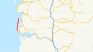
State Route 103 (SR 103) is a 19.97-mile-long (32.14 km) state highway serving the Long Beach Peninsula, located within Pacific County in the U.S. state of Washington. The highway travels north from U.S. Route 101 (US 101) in Seaview through Long Beach and Ocean Park to the southern entrance of Leadbetter Point State Park. SR 103 was created in the 1964 highway renumbering, replacing the earlier Secondary State Highway 12A (SSH 12A) that was created in 1937 to serve Long Beach and Ocean Park, later extended north in 1991 to serve Leadbetter Point State Park.

The Sebasticook River is a 76-mile-long (122 km) river in the central part of Maine, in the United States. From its source in Dexter, the upper "Main Stream" section flows generally west and south 30 miles (48 km) to Great Moose Lake. From the outlet of the lake in Hartland, the Sebasticook flows 41 miles (66 km) south to the Kennebec River in Winslow.
Newall Glacier is a glacier in the east part of the Asgard Range of Victoria Land, flowing east between Mount Newall and Mount Weyant into the Wilson Piedmont Glacier. In its uppermost névé area sits Kaminuma Crag, a craggy, island-like nunatak, 0.75 nautical miles (1.4 km) long, rising to 1,750 metres (5,740 ft) high.
The Mill River is a tributary of the Saint George River in Thomaston, Maine. From the confluence of Branch Brook and Meadow Brook, the river runs 2.7 miles (4.3 km) south to the head of the estuary of the Saint George.
Lake Brook is a river in Delaware County, New York. It drains Odell Lake and flows south before converging with the West Branch Delaware River west of Hobart.
Horse Brook is a river in Delaware County, New York. It drains Lake Mimi and flows south before converging with Beaver Kill northwest of Roscoe.

Loomis Mountain is a mountain located in the Catskill Mountains of New York northwest of Walton. Walton Mountain is located south, Pines Brook Ridge is located southeast, and Gallop Hill is located north-northwest of Loomis Mountain.
Pleasant Brook is a river in Otsego County, New York. It converges with Cherry Valley Creek west of Pleasant Brook.
Windfall Brook is a river in Delaware County, New York. It flows into Loomis Brook south-southwest of the hamlet of Loomis.
Teed Pond is a small lake located north-northeast of the hamlet of Loomis in Delaware County, New York. It drains south via Loomis Brook which flows into the Cannonsville Reservoir.
Loomis is a hamlet in Delaware County, New York. It is located northwest of Walton at the corner of NY–206 and Loomis Brook Road. Loomis Brook flows south through the hamlet.
Northfield is a hamlet in Delaware County, New York. It is located northwest of Walton at the corner of White Hill Road and Loomis Brook Road. Kerrs Creek flows southeast through the hamlet. Teed Pond is located west and Loomis Mountain is located south-southwest of the hamlet.