
Rivière-du-Loup is a regional county municipality in the Bas-Saint-Laurent region of Quebec, Canada. Its most important city is Rivière-du-Loup, which contains more than half of the population.

The Loup River is a tributary of the Platte River, approximately 68 miles (109 km) long, in central Nebraska in the United States. The river drains a sparsely populated rural agricultural area on the eastern edge of the Great Plains southeast of the Sandhills. The name of the river means "wolf" in French, named by early French trappers after the Skidi band of the Pawnee, whose name means "Wolf People," and who lived along its banks. The river and its tributaries, including the North Loup, Middle Loup, and South Loup, are known colloquially as "the Loups", comprising over 1800 mi (2900 km) of streams and draining approximately one-fifth of Nebraska.
The Dungeness River is a 28-mile (45 km) long river located in the Olympic Peninsula in the U.S. state of Washington. It rises near Mount Constance in the Olympic Mountains within the Olympic National Park, flows through the Buckhorn Wilderness, passes by the town of Sequim, and empties into the Strait of Juan de Fuca at Dungeness Bay, behind the Dungeness Spit. One of its main tributaries is the Gray Wolf River. It is crossed by the Dungeness River Bridge.
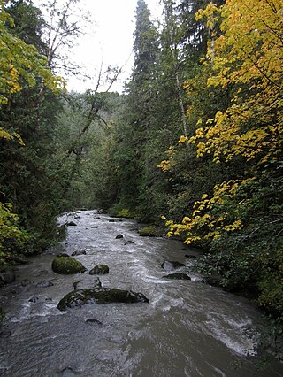
The Gray Wolf River is a river of the Olympic Peninsula in Washington. It is a tributary of the Dungeness River. It heads near Gray Wolf Pass and drains the west slope of The Needles.

Malott is a census-designated place (CDP) in Okanogan County, Washington, United States, within the Greater Omak Area. The population was 487 at the 2010 census.

Deep Water, also known historically as Deepwater, is a census-designated place on the Kanawha River in Fayette County, West Virginia, United States. As of the 2010 census, its population was 280. It is best known as the starting point of the Deepwater Railway founded in 1898 by William N. Page, which was merged to create the Virginian Railway in 1907.
Black Wolf is an unincorporated community located in McDowell County, West Virginia, United States. Black Wolf lies along the Norfolk and Western Railroad on the Tug Fork River.

James Island is one of the San Juan Islands in San Juan County, Washington, United States. It lies in Rosario Strait just off the eastern shore of Decatur Island and west of the city of Anacortes. The entire island comprises James Island State Park of the Washington State Park System. It has a land area of 113 acres (46 ha) with 12,335 feet (3,760 m) of saltwater shoreline. The island has no potable water or residents. It has three different camping areas, each with at least one toilet. The camping areas combine for a total of 13 campsites and are connected by a loop trail. James Island was named by Charles Wilkes in 1841 to commemorate the naval hero Reuben James. The property was transferred from the federal government to the Washington State Parks and Recreation Commission in 1964.

The Wolf River is a 45.7-mile-long (73.5 km) tributary of the Missouri River in northeastern Kansas in the United States, draining an area of 247.8 square miles (642 km2) in the Dissected Till Plains region.
The Kudobin Islands are a group of small islands in the Bering Sea, near the coast of Alaska, 13 miles (21 km) west of Port Moller, Bristol Bay Low. The group includes a cluster of other small coastal islands, the Walrus and Kritskoi Islands, forming a geographical whole.
The Walrus and Kritskoi Islands are a group of small islands in the Bering Sea, close to the coast of Alaska. The group is part of a cluster of other small coastal islands called the Kudobin Islands.
Robson is an unincorporated community in Fayette County, West Virginia, United States, situated primarily on the banks of Loup Creek. Robson is served by State Highway 61, and is located 8 miles (13 km) from Montgomery and 15 miles (24 km) from Oak Hill. Robson's Post Office serves the smaller communities of Beards Fork and Mulberry.

Wolf Creek Inn State Heritage Site is a state park in the U.S. state of Oregon, administered by the Oregon Parks and Recreation Department.

LeLoup is an unincorporated community in Franklin County, Kansas, United States. It is located a mile and half north of Interstate 35 on Tennessee Road, 11 miles northeast of Ottawa, 7 miles southwest of Wellsville.

Modoc Point is an unincorporated community in Klamath County, Oregon, United States on U.S. Route 97 on the shore of Upper Klamath Lake.
Loup is an extinct Algonquian language, or possibly group of languages, spoken in colonial New England. It was attested in a notebook titled Mots loups, compiled by Jean-Claude Mathevet, a priest who worked among Algonquian peoples, composing of 124 pages. Loup ('Wolf') was a French colonial ethnographic term, and usage was inconsistent. In modern literature, it refers to two varieties, Loup A and Loup B. The language of the Mots loups notebook is different from all other New England languages, and is believed to have been spoken by the Nipmuc.

Loop Creek, also known by the spelling Loup Creek, is a tributary of the Kanawha River, 20 miles (32 km) long, in southern West Virginia in the United States. Via the Kanawha and Ohio rivers, it is part of the watershed of the Mississippi River, draining an area of 49.6 square miles (128 km2) in a coal mining region on the unglaciated portion of the Allegheny Plateau.
Patten Mills is an unincorporated community in Washington County, in the U.S. state of Ohio.

Silverton is an unincorporated community in Snohomish County, in the U.S. state of Washington.


