Lord Roberts (electoral district)

Last updated

The 1999-2011 boundaries for the Lord Roberts electoral district highlighted in red LordRoberts98.png
The 1999-2011 boundaries for the Lord Roberts electoral district highlighted in red

Lord Roberts was a provincial electoral division in the Canadian province of Manitoba, located in the south-central section of the City of Winnipeg. It was created by redistribution in 1999, and consists primarily of territory taken from the now-defunct ridings of Osborne and Crescentwood. The district is named after Field Marshal Lord Roberts.

Contents

Lord Roberts was bordered to the south by Fort Garry and St. Vital, to the west by River Heights, to the north by Fort Rouge and St. Boniface and to the east by St. Vital.

Lord Roberts' population in 1996 was 20,469. The average family income in 1999 was $44,963, with an unemployment rate of 7.70%. Thirty-one per cent of the riding's residents are listed as low income. Over 47% of the riding's dwelling houses in 1999 were rental units, and over 20% of the riding's families were single-parent.

Over 19% of the riding's population was above 65 years of age. 14% per cent of the riding's residents were immigrants, including 5% German and 4% Ukrainian. Four percent of the riding's residents were Jewish.

The service sector accounts for 19% of Lord Roberts's industry, followed by 13% in health and social services.

The riding was only ever held by the New Democratic Party of Manitoba (NDP), and was generally considered safe for the party. Its only MLA was Diane McGifford, who was re-elected in 2003 with over 60% of the riding's popular vote.

For the 2011 election, the riding was dissolved into Fort Rouge, River Heights, and the new riding of Fort Garry-Riverview

List of provincial representatives

NamePartyTook officeLeft office
Diane McGifford NDP 19992011

Electoral results

2007 Manitoba general election
PartyCandidateVotes%±%Expenditures
New Democratic Diane McGifford 4,49957.86%+4.87$23,588.33
Progressive Conservative Wilf Makus1,36717.58%−9.50$3,999.86
Liberal Larry Schenkeveld1,21915.68%−2.28$2,057.12
Green Vere Scott6558.42%+7.04$37.30
Total valid votes7,74099.54
Rejected and declined votes36
Turnout7,77655.56+1.87
Electors on the lists13,996
2003 Manitoba general election
PartyCandidateVotes%±%Expenditures
New Democratic Diane McGifford 4,35261.69+8.70$13,278.88
Progressive Conservative Andrew Hymers1,17916.71−10.37$984.54
Liberal Ali Lamont98213.92−4.04$6,196.49
Green Vere Scott4426.27+4.92$316.47
Libertarian Andy Caisse660.94$0.00
Total valid votes7,02199.52
Rejected and declined votes34
Turnout7,05553.69−15.59
Electors on the lists13,141
1999 Manitoba general election
PartyCandidateVotes%±%Expenditures
New Democratic Diane McGifford 5,24052.99$25,700.00
Progressive Conservative Maggie Nishimura2,67827.08$17,064.57
Liberal Allen Mills1,77617.96$13,560.50
Green Lyle Ford1361.38$127.62
Total valid votes9,83199.42
Rejected and declined votes57
Turnout9,88869.28
Electors on the lists14,272

[1]

Related Research Articles

<span class="mw-page-title-main">Elmwood (electoral district)</span> Provincial electoral district in Manitoba, Canada

Elmwood is a provincial electoral division in the Canadian province of Manitoba.

<span class="mw-page-title-main">St. Johns (electoral district)</span> Provincial electoral district in Manitoba, Canada

St. Johns is a provincial electoral division in the Canadian province of Manitoba. It was created by redistribution in 1957, and has formally existed since 1958. It is located in the north-end of Winnipeg. The constituency is bordered by Kildonan to the north and west, Burrows to the west, Elmwood to the east, and Point Douglas to the south.

<span class="mw-page-title-main">Burrows (electoral district)</span> Provincial electoral district in Manitoba, Canada

Burrows is a provincial electoral division in the Canadian province of Manitoba. It was created by redistribution in 1957 from part of Winnipeg North, and formally came into existence in the provincial election of 1958. The riding is located in the northern part of Winnipeg.

<span class="mw-page-title-main">Wellington (Manitoba provincial electoral district)</span> Defunct provincial electoral district in Manitoba, Canada

Wellington was a provincial electoral division in the Canadian province of Manitoba. It was first created by redistribution in 1957, and formally came into being in the provincial election of 1958. The riding was eliminated in 1979, but was re-established in 1989. It was eliminated again for the 2011 election. It is located in the northwestern section of the city of Winnipeg, and is named after Arthur Wellesley, 1st Duke of Wellington.

<span class="mw-page-title-main">Fort Rouge (electoral district)</span> Provincial electoral district in Manitoba, Canada

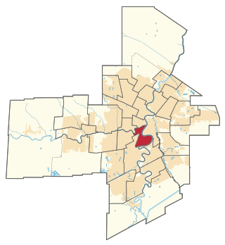
Fort Rouge is a provincial electoral division in the Canadian province of Manitoba. It was created by redistribution in 1957, and formally came into existence in the general election of 1958. The riding was eliminated in 1989, and re-established in 1999. It is located in the central section of the City of Winnipeg.

<span class="mw-page-title-main">Wolseley (Manitoba electoral district)</span> Provincial electoral district in Manitoba, Canada

Wolseley is a provincial electoral division in the Canadian province of Manitoba. It was created by redistribution in 1957, and has formally existed since the 1958 provincial election. The riding is located in the centre of the City of Winnipeg. It is named for Col. Garnet Joseph Wolseley, the nineteenth-century army officer who played a significant role in crushing the Red River Rebellion in 1870.

<span class="mw-page-title-main">Minto (electoral district)</span> Defunct provincial electoral district in Manitoba, Canada

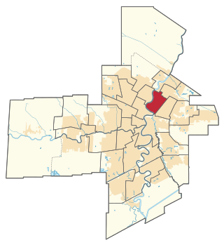
Minto was a provincial electoral division in the Canadian province of Manitoba. It was created by redistribution in 1999, and has formally existed since the provincial election of 1999. The riding is located in the centre of the City of Winnipeg.

<span class="mw-page-title-main">Kirkfield Park</span> Provincial electoral district in Manitoba, Canada

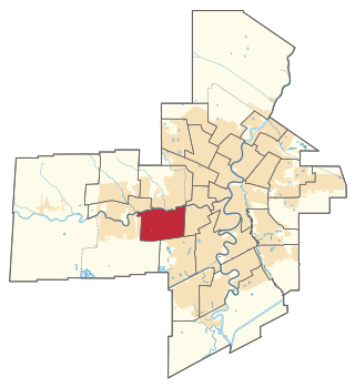
Kirkfield Park is a provincial electoral division in the Canadian province of Manitoba. It was created by redistribution in 1979, and has formally existed since the provincial election of 1981. The riding is located in the westernmost tip of the City of Winnipeg. It contains the neighbourhoods of Glendale, Westwood, Kirkfield Park, Woodhaven, Birchwood, Booth, Silver Heights and part of Assiniboia Downs

<span class="mw-page-title-main">Charleswood (electoral district)</span> Defunct provincial electoral district in Manitoba, Canada

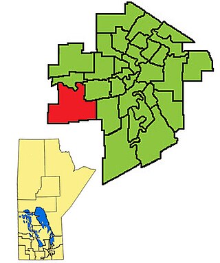
Charleswood was a provincial electoral division in the Canadian province of Manitoba. It was created by redistribution in 1968, and formally existed from the provincial election of 1969 until that of 2019. The riding was in the westernmost tip of Manitoba's capital and largest city, Winnipeg.

<span class="mw-page-title-main">Tuxedo (electoral district)</span> Provincial electoral district in Manitoba, Canada

Tuxedo is a provincial electoral division in the Canadian province of Manitoba. It was created by redistribution in 1979, and has formally existed since the provincial election of 1981. The riding is located in the southwest section of the city of Winnipeg.

<span class="mw-page-title-main">River Heights (electoral district)</span> Provincial electoral district in Manitoba, Canada

River Heights is a provincial electoral division in the Canadian province of Manitoba. It was created by redistribution in 1957, and formally came into existence in the 1958 provincial election. The riding is located in the south-central region of the City of Winnipeg.

<span class="mw-page-title-main">St. Vital (electoral district)</span> Provincial electoral district in Manitoba, Canada

St. Vital is a provincial electoral division in the Canadian province of Manitoba.

<span class="mw-page-title-main">Southdale (electoral district)</span> Provincial electoral district in Manitoba, Canada

Southdale is a provincial electoral division in the Canadian province of Manitoba. It was created in the provincial redistribution 1999, mostly out of Niakwa and part of St. Vital. The riding is located in the southeastern section of the City of Winnipeg.

<span class="mw-page-title-main">Riel (electoral district)</span> Provincial electoral district in Manitoba, Canada

Riel is a provincial electoral division or riding in the Canadian province of Manitoba. It was created by redistribution in 1968, and has formally existed since the provincial election of 1969. The riding is located in the south-central region of Winnipeg, Manitoba's capital and largest city, and is named after Louis Riel, the leader of the 1870 Red River Rebellion.

<span class="mw-page-title-main">Fort Garry (electoral district)</span> Provincial electoral district in Manitoba, Canada

Fort Garry is a provincial electoral division in the Canadian province of Manitoba that existed from 1958 to 2011 and was re-created in 2019. It was first created by redistribution in 1957 from parts of Iberville, Assiniboia and St. Boniface, and formally existed beginning with the 1958 provincial election. The riding is in the south-central and southwestern region of the city of Winnipeg. It is named for the historical Fort Garry which was occupied by supporters of Louis Riel during the Red River Rebellion of 1870.

<span class="mw-page-title-main">Fort Whyte</span> Provincial electoral district in Manitoba, Canada

Fort Whyte is a provincial electoral division in the Canadian province of Manitoba. It was created in 1999, after the provincial electoral boundaries commission determined that southwestern Winnipeg had experienced enough population growth to deserve an extra seat. Fort Whyte was created from territory formerly belonging to Tuxedo, Fort Garry and St. Norbert.

<span class="mw-page-title-main">St. Norbert (electoral district)</span> Defunct provincial electoral district in Manitoba, Canada

St. Norbert is a former provincial electoral division in the Canadian province of Manitoba.

<span class="mw-page-title-main">Fort Rouge, Winnipeg</span>

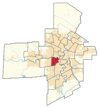
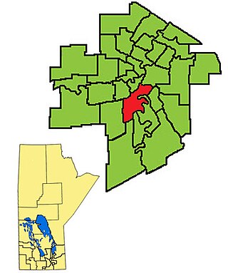
Fort Rouge is a district of Winnipeg, Manitoba, in Canada. Located in the south-central part of the city, it is bounded on the north by the Assiniboine River, on the east and south by the Red River, and on the west by Stafford Street and Pembina Highway.

<span class="mw-page-title-main">Fort Garry-Riverview</span> Defunct provincial electoral district in Manitoba, Canada

Fort Garry-Riverview was a provincial electoral division in the Canadian province of Manitoba. It was created by the decennial electoral redistribution in 2008, out of parts of Lord Roberts and Fort Garry. It was in south-central Winnipeg.

References

  1. "Summary of Results - 1999 General Election". Archived from the original on August 7, 2011. Retrieved August 10, 2010. - 1999 Results

49°51′54″N97°08′42″W / 49.865°N 97.145°W / 49.865; -97.145