Related Research Articles
Skookumchuck is in the East Kootenay region of southeastern British Columbia. This locality straddles both shores of the Kootenay River north of the mouth of the Lussier River. The crossing, on the merged section of highways 93 and 95, is by road about 54 kilometres (34 mi) north of Cranbrook and 193 kilometres (120 mi) southeast of Golden.
Eholt is in the Boundary Country region of south central British Columbia. This ghost town, on BC Highway 3, is by road about 27 kilometres (17 mi) northwest of Grand Forks and 14 kilometres (9 mi) northeast of Greenwood.

Midway is in the West Kootenay region of south central British Columbia. The village lies 13 kilometres (8 mi) west of Greenwood and 51 kilometres (32 mi) east of Osoyoos along Highway 3.
Silverton is a village about 5 kilometres (3 mi) south of New Denver in the West Kootenay region of southeastern British Columbia. The former steamboat landing is at the mouth of Silverton Creek on the eastern shore of Slocan Lake. The locality, on BC Highway 6 at the junction of BC Highway 31A, is about 95 kilometres (59 mi) by road north of Castlegar and 155 kilometres (96 mi) by road and ferry south of Revelstoke.
Alexandria or Fort Alexandria was a general area encompassing a trading post, ferry site, and steamboat landing in the North Cariboo region of central British Columbia. The present unincorporated community is on the eastern side of the Fraser River. On BC Highway 97, the locality is by road about 74 kilometres (46 mi) northwest of Williams Lake and 45 kilometres (28 mi) south of Quesnel.
Kettle Valley is on the south side of the Kettle River in the Boundary region of south central British Columbia. The unincorporated settlement, on Kettle Valley Rd S., is by road about 29 kilometres (18 mi) west of Greenwood and 56 kilometres (35 mi) east of Osoyoos.
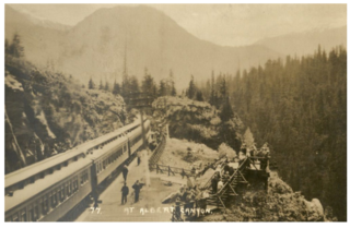
Albert Canyon is a railway point in the West Kootenay region of southeastern British Columbia. The community was immediately east of the mouth of Albert Creek on the south shore of the Illecillewaet River. That settlement no longer exists, but the Canyon Hot Springs Resort borders to its north. On BC Highway 1, the locality is by road about 33 kilometres (21 mi) northeast of Revelstoke and 30 kilometres (19 mi) southwest of Glacier.
Boat Encampment is a ghost town in the East Kootenay region of southeastern British Columbia. The locality was at the tip of the Big Bend on the north shore of the Columbia River. The general vicinity, on the former Big Bend Highway, was by road about 151 kilometres (94 mi) northwest of Golden and 159 kilometres (99 mi) north of Revelstoke.
Birken is an unincorporated community on the north shore of Gates Lake in the Squamish-Lillooet region of southwestern British Columbia. On Pemberton Portage Road, the locality is by road about 182 kilometres (113 mi) north of Vancouver and 62 kilometres (39 mi) northeast of Whistler.
Cody is at the confluence of Cody Creek into Carpenter Creek in the West Kootenay region of southeastern British Columbia. The ghost town, about one kilometre east of Sandon, lies off BC Highway 31A. By road, the former mining community is about 15 kilometres (9 mi) east of New Denver and 44 kilometres (27 mi) west of Kaslo.
Thrums is an unincorporated community on the northwest shore of the Kootenay River in the West Kootenay region of southeastern British Columbia. The location, on BC Highway 3A, is by road about 11 kilometres (7 mi) northeast of Castlegar, and 33 kilometres (21 mi) southwest of Nelson.
Vallican is an unincorporated community on the west side of the Slocan River in the West Kootenay region of southeastern British Columbia. At the mouth of the Little Slocan River, the locality formerly spanned both sides of the Slocan River. The rural neighbourhood is off BC Highway 6 about 30 kilometres (19 mi) south of Slocan, and 39 kilometres (24 mi) north of Castlegar.
Johnsons Landing is an unincorporated community in the West Kootenay region of southeastern British Columbia. The former steamboat landing comprises scattered rural properties adjacent to the mouth of Gar Creek. To the north is Gardner Creek and to the south is Fry Creek, the three creek mouths on the northeast shore of Kootenay Lake. The locality, via BC Highway 31 and Argenta Rd, is about 121 kilometres (75 mi) northeast of Nelson.
Three Forks is a ghost town at the junction of Carpenter, Seaton, and Kane creeks in the West Kootenay region of southeastern British Columbia. This former mining community, on BC Highway 31A, is by road about 8 kilometres (5 mi) east of New Denver and 38 kilometres (24 mi) west of Kaslo.
Niagara is on the west side of the Granby River, near the junction with Fisherman Creek, in the Boundary Country region of south central British Columbia. The small community is about 12 kilometres (7 mi) north of Grand Forks on North Fork Rd.
Paulson is a ghost town in the Boundary Country region of south central British Columbia. The locality, on the Paulson Detour Rd off Highway 3, is about 26 kilometres (16 mi) northeast of Christina Lake and 54 kilometres (34 mi) west of Castlegar.
Lemon Creek is an unincorporated community on the east side of the Slocan River in the West Kootenay region of southeastern British Columbia. The locality is on BC Highway 6 about 8 kilometres (5 mi) south of Slocan, and 62 kilometres (39 mi) north of Castlegar.
Kildonan is an unincorporated community in the Alberni Inlet-Barkley Sound region of the west coast of southern Vancouver Island, British Columbia. The former steamboat landing and ferry dock is on the east shore of Uchuchklesit Inlet, which branches northwest of the lower reaches of Alberni Inlet. Adjacent to Pacific Rim National Park Reserve, the locality is by road and ferry about 120 kilometres (75 mi) southwest of Port Alberni.

Parson is an unincorporated community on the east shore of the Columbia River, in the Columbia Valley region of southeastern British Columbia. The locality, on BC Highway 95, is by road about 212 kilometres (132 mi) north of Cranbrook and 35 kilometres (22 mi) southeast of Golden.
Beavermouth is about 43 kilometres (27 mi) west of Golden, and about 32 kilometres (20 mi) east of the mid-point of the Connaught Tunnel beneath Rogers Pass, in southeastern British Columbia. At the mouth of the Beaver River, the train station was called Beavermouth, but the adjacent community, which no longer exists, was known as Beaver or Beaver Mouth. Nowadays, the closest road access is to the nearby Kinbasket Lake Resort.
References
- ↑ "Lorne Creek (creek)". BC Geographical Names .
- ↑ N.L. Barlee (1980). The Guide to Gold Panning, Revised Second Edition, Second Printing. Canada West Publications. ISBN 0-920164-04-8.
- ↑ "Lorne Creek". www.gent.name.
- ↑ "Postmasters". www.bac-lac.gc.ca.
- ↑ "1918 BC Directory". www.bccd.vpl.ca.
to "1929 BC Directory". www.bccd.vpl.ca. - ↑ "Prince George Citizen". pgnewspapers.pgpl.ca. 24 Oct 1940. p. 1.