
The Pudding River is a 62-mile (100 km) tributary of the Molalla River in the U.S. state of Oregon. Its drainage basin covers 528 square miles (1,368 km2). Among its tributaries are Silver Creek, Butte Creek, Abiqua Creek, and the Little Pudding River.

The Calapooia River is an 80-mile (130 km) tributary of the Willamette River in the U.S. state of Oregon.

The McKenzie River is a 90-mile (145 km) tributary of the Willamette River in western Oregon in the United States. It drains part of the Cascade Range east of Eugene and flows westward into the southernmost end of the Willamette Valley. It is named for Donald McKenzie, a Scottish Canadian fur trader who explored parts of the Pacific Northwest for the Pacific Fur Company in the early 19th century. As of the 21st century, six large dams have been built on the McKenzie and its tributaries.

The South Santiam River is a tributary of the Santiam River, about 69 miles (111 km) long, in western Oregon in the United States. It drains an area of the Cascade Range into the Willamette Valley east of Corvallis.

The Calapooya Mountains are a mountain range in Lane and Douglas counties of southwestern Oregon in the United States. The range runs for approximately 60 miles (97 km) west from the Cascade Range between Eugene on the north and Roseburg on the south.

The Mohawk River is the largest tributary of the McKenzie River, approximately 30 miles (48 km) long, in west central Oregon in the United States. It drains part of the foothills of the Cascade Range on the southeast end of the Willamette Valley northeast of Springfield.

Dexter is an unincorporated community in Lane County, Oregon, United States. It is located near Dexter Reservoir, a.k.a. Dexter Lake, a reservoir of the Middle Fork Willamette River along Oregon Route 58.

The Middle Fork Willamette River is one of several forks that unite to form the Willamette River in the western part of the U.S. state of Oregon. It is approximately 115 miles (185 km) long, draining an area of the Cascade Range southeast of Eugene, which is at the southern end of the Willamette Valley.

Elijah Bristow State Park is a state park in the U.S. state of Oregon, administered by the Oregon Parks and Recreation Department. It has more than 10 miles (16 km) of well-maintained trails along ponds, wetlands, meadows, and the Middle Fork Willamette River, and through forests of broadleaf and evergreen trees. The trails are open to horses, hikers, and mountain bikers, and there is a separate equestrian staging area popular with riding clubs.

Salt Creek Falls is a cascade and plunge waterfall on Salt Creek, a tributary of the Middle Fork Willamette River, that plunges into a gaping canyon near Willamette Pass in the Willamette National Forest, near Oakridge, Oregon. The waterfall is notable for its main drop of 286 feet (87 m) which makes it the third highest plunge waterfall in Oregon after Multnomah Falls and Watson Falls the second highest, which was re-measured in 2009 and found to be 293 feet rather than an earlier measurement of 272 feet passing Salt Creek Falls. The pool at the bottom of the waterfall is 20 metres (66 ft) deep.

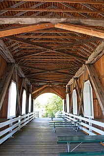
The Parvin Bridge is a covered bridge located in Lane County, Oregon, U.S. near Dexter. It was built in 1921 as a single-lane 75-foot (23 m) bridge across Lost Creek, a tributary of the Middle Fork Willamette River.

Pringle Creek is a small tributary of the Willamette River that drains a 15-square-mile (39 km2) area of Marion County in the U.S. state of Oregon. The entire watershed lies within the urban growth boundary of the City of Salem. Pringle Creek's tributaries include Clark Creek, West Fork Pringle Creek, West Middle Fork and East Fork.

Hills Creek is a tributary, about 16 miles (26 km) long, of the Middle Fork Willamette River in the U.S. state of Oregon. From its headwaters on Juniper Ridge in the Cascade Range, the creek flows northwest through Lane County and the Willamette National Forest for its entire course.

Salt Creek is a tributary, 30 miles (48 km) long, of the Middle Fork Willamette River in Lane County in the U.S. state of Oregon. It is named for salt springs along its banks that are used as licks by deer. The stream originates as an outflow of Lower Betty Lake in the forested Cascade Range just southeast of Waldo Lake. From its source, Salt Creek flows generally south, through Gold Lake, to Route 58, which it then follows mainly northwest for about 26 miles (42 km) to its mouth at the Middle Fork Willamette River just below Hills Creek Dam. At Salt Creek Falls—roughly 4 miles (6.4 km) west of Willamette Pass and a little more than 22 miles (35 km) upstream from the mouth—the stream plunges 286 feet (87 m), discharging an average of 50,000 U.S. gallons (190,000 L) of water per minute, or 111 cubic feet per second (3.1 m3/s). Below the falls, the creek enters a narrow canyon shaped by glaciation and basalt lava flows from higher in the Cascades. McCredie Hot Springs, at the former community of McCredie Springs, are natural hot springs along the lower half of Salt Creek beside Route 58.
Muddy Creek is a tributary of the Willamette River that flows through parts of Lane and Linn counties in the U.S. state of Oregon. It begins near Coburg Ridge, northeast of Eugene, and meanders north across the floor of the Willamette Valley roughly parallel to the river. It joins the East Channel of the Willamette upstream of Corvallis.

Mosby Creek is a 21-mile (34 km) tributary of the Row River in Lane County, in the U.S. state of Oregon. It begins at the confluence of the east and west forks of the creek near the Calapooia Divide and the border with Douglas County. From its source it flows generally north-northwest to meet the river slightly east of Cottage Grove and about 4 miles (6 km) from the larger stream's confluence with the Coast Fork Willamette River.
The Little River is a tributary of the Coast Fork Willamette River in the U.S. state of Oregon. Rising along the Calapooya Divide near the border between Lane and Douglas counties, it flows generally west-northwest to meet the Big River. The combined Big and Little rivers form the Coast Fork near Black Butte. The butte is a dark-colored mountain, the site of a former mine, and the site of a former post office.
Garoutte Creek is a tributary of the Little River in the U.S. state of Oregon. Rising along the Calapooya Divide near the border between Lane and Douglas counties, it flows generally northeast to meet the larger stream near Black Butte. The butte is a dark-colored mountain, the site of a former mine, and the site of a former post office. Little River joins Big River a few miles downstream to form the Coast Fork Willamette River.
Ritner Creek is a tributary of the Luckiamute River in Polk County in the U.S. state of Oregon. The creek begins near Bald Mountain in the Central Oregon Coast Range and flows generally southeast to meet the Luckiamute southwest of Pedee and north of Kings Valley. The confluence is 31 miles (50 km) upstream of the Luckiamute's mouth on the Willamette River. Named tributaries of Ritner Creek from source to mouth are Sheythe, Love, Clayton, and Kinsey creeks.

Horse Creek is a tributary of the McKenzie River in near the unincorporated community of McKenzie Bridge in Lane County in the U.S. state of Oregon. It begins in the Cascade Range in the Three Sisters Wilderness of the Willamette National Forest. Its headwaters are near the Deschutes County border and the Pacific Crest Trail. It flows generally northwest to meet the river about 65 miles (105 km) upstream of the McKenzie's confluence with the Willamette River.

