
The Lost Hills Oil Field is a large oil field in the Lost Hills Range, north of the town of Lost Hills in western Kern County, California, in the United States.
The Lost Hills Oil Field is a large oil field in the Lost Hills Range, north of the town of Lost Hills in western Kern County, California, in the United States.
While only the 18th-largest oil field in California in size, in total remaining reserves it ranks sixth, with the equivalent of over 110 million barrels (17,000,000 m3) producible reserves still in the ground, according to the California Division of Oil, Gas and Geothermal Resources (Chevron Corp., the principal operator, estimates considerably more oil in the ground). [1] [2] Production at Lost Hills has been increasing steadily: as of the end of 2006, it was California's second fastest-growing oil field, exceeded only by the nearby Cymric Field.
The Lost Hills field also contains considerable reserves of natural gas. In 1998, one of the field's gas wells was the site of a spectacular blowout, producing a pillar of fire which burned for 14 days and was visible more than 40 miles (64 km) away. [3]

The Lost Hills Field underlies a long, low range of southeast-to-northwest trending hills of the same name adjacent to the San Joaquin Valley. The hills rise scarcely more than 200 feet (61 m) above the San Joaquin Valley to the east, and only 100 feet (30 m) or less above the Antelope Plain to the west; in places they are almost flat. The hills and associated oil field are between Interstate 5 to the east and State Route 33 to the west, both of which parallel the field; Interstate 5 runs about 4 miles (6.4 km) away and Route 33 about 7 miles (11 km). The California Aqueduct runs adjacent to the field boundary on the northeast, and the town of Lost Hills is on the other side of the aqueduct along California State Route 46, which passes through the field from east to west.
The climate in the Lost Hills area is arid to semi-arid, with an average rainfall of 5 to 6 inches (130 to 150 mm) a year, almost all in the winter months. Vegetation in the vicinity of the field is mostly grassland and sparse scrub, with some adjacent orchards, although in the oil field itself most vegetation has been removed from the areas of active operations.

The Lost Hills Field is one of a series of oil fields along anticlines between the Coalinga Oil Field on the north and the Midway-Sunset Field on the south, along the western edge of the San Joaquin Valley. These anticlines run closely parallel to the San Andreas Fault to the west, and formed as a result of compression from tectonic movement. The Lost Hills Field occupies a portion of a SE-plunging anticline. There are six oil pools in the five producing units, which are, from the top, the Tulare Formation, of Pleistocene age; the Etchegoin Formation, of Pliocene age; the Reef Ridge Shale, McClure Shale, and Devilwater Shale, members of the Monterey Formation, of Miocene age, which can be found in much of coastal California; and the Temblor formation, underneath the others, of Oligocene and Miocene age. A well drilled to 11,553 feet (3,521 m) by Mobil Oil Corp. in the Williamson Lease identified further rock units as old as the Upper Cretaceous below the Temblor, but none of these lowest units have had oil pools. [4]
The Belridge Diatomite portion of the Monterey Formation defines the productive limits of the field. Characteristic of this rock unit is that it is full of oil – almost 50% of the unit is saturated, and the unit has high porosity, in the 45% to 70% range – but very little of the oil has been recoverable from the unit (only three to four percent so far). According to Chevron's estimate, there are approximately 2.2 billion barrels (350,000,000 m3) of oil in place in the Lost Hills Field, only five percent of which has been extracted. The oil in place is about twenty times greater than the California Department of Oil and Gas reserves estimate (109 million barrels (17,300,000 m3)), which is volume that can be economically produced. [5]
Well spacing on Lost Hills varies based on the geologic characteristics in the unit being drilled, with one well per 5 acres (20,000 m2) in siliceous shale to one well per 1.25 acres (5,100 m2) in diatomite. [6]
A peculiarity of the Lost Hills operations is the pronounced subsidence of the ground surface as it collapses into the area vacated by the petroleum after being pumped out. Portions of the hills overlying the oil field have subsided up to 8 feet (2.4 m) in the central region of operations, and subsidence occurs field-wide at a rate of about 9 inches (230 mm) per year. The dropping land surface causes operational problems, including fractures of well casings, and sometimes complete well failures. Waterflooding – the practice of filling the reservoir with water to push petroleum to recovery wells, and thereby also reoccupying the space vacated by oil and gas – has partially mitigated the problem. [7] [8] Some wells have actually disappeared into craters: in 1976, a Getty Oil well blew out, and quickly collapsed into a crater over 15 feet (4.6 m) deep and 30 feet (9.1 m), taking with it the concrete pad, casing, and pumping unit. Yet another Getty well suffered the same fate in 1978. [9]
Drillers Martin and Dudley accidentally discovered the Lost Hills Oil Field in July 1910. They were drilling a water well for livestock grazing; instead of finding groundwater, however, they struck oil, specifically the Etchegoin Pool at a depth of 530 feet (160 m). Other drillers, encouraged by the find, including the mighty Standard Oil of California, which had recently been subject to antitrust litigation and broken up by the Supreme Court, began drilling for more nearby; they soon found the Cahn and Reef Ridge pools, in 1913, and then the Tulare pool in 1915. [10] There were relatively few wells on the field for the first several decades; indeed, by 1979, there were only 39 wells producing from the Monterey Formation, and each of these wells only produced an average of eight barrels per day. It took the development of advanced recovery technology to turn the Lost Hills into a high-producing oil field.
Unusual for a California oil field, the years of maximum recovery were not early in the 20th century, but recently: peak oil production from the Etchegoin Pool did not occur until the early 21st century, assisted by several enhanced recovery technologies, including water flooding and cyclic steam flooding. The early peak in production took place in 1917, during which 4 million barrels (640,000 m3) of oil were pumped; then production steadily declined, with a few spikes, until the enhanced recovery techniques which began to be employed in the 1960s began to pay off. In 1981 the field produced almost 6 million barrels (950,000 m3), and has remained a high producer, reaching close to 12 million barrels (1,900,000 m3) in 2006. During that year it had the fourth-largest production increase in the state, and preliminary estimates for 2007 show that production has increased yet again, to 12.2 million barrels (1,940,000 m3) [11] [12] [13]
As of 1997, four pools – the Tulare, Etchegoin, Cahn, and Reef Ridge – continued to have active recovery operations using waterflooding, steam flooding, and fire flooding. [10] As of 2008, the principal operators on the Lost Hills Field were Chevron Corp. and Aera Energy LLC.

In 1998, the Lost Hills Field was the site of one of the largest and most spectacular well blowouts in modern U.S. history. The Bellevue blowout – also called the "Bellevue gusher" – involved six months of uncontrolled natural gas expulsion, and a gigantic gas fire that lasted two weeks.
On the evening of November 23, a wildcat well being drilled into a promising anticlinal fold underneath the Monterey Formation, northeast of the main Lost Hills field, reached the depth of 17,000 feet (5,200 m) and hit a previously untapped reservoir of gas under intense pressure. Natural gas and petroleum condensate burst from the well, immediately exploding into flame, knocking over the massive drilling rig, destroying the trailer, and melting the nearby drilling equipment. This enormous pillar of fire, which rose to 340 feet (100 m) into the sky, could be seen more than 40 miles (64 km) away, and the quantity of oil release was estimated at 2,000 barrels (320 m3 ) of oil per day and gas bursting from the well has been estimated at 80 million cubic feet (2.3 million cubic metres ) per day at standard conditions. It burned for fourteen days, and continued spewing even after the fire was out; only a secondary well bore, drilled at a slant to intercept the main well, was able to plug the opening and snuff the blowout at last. [14]

The Bakken Formation is a rock unit from the Late Devonian to Early Mississippian age occupying about 200,000 square miles (520,000 km2) of the subsurface of the Williston Basin, underlying parts of Montana, North Dakota, Saskatchewan and Manitoba. The formation was initially described by geologist J. W. Nordquist in 1953. The formation is entirely in the subsurface, and has no surface outcrop. It is named after Henry O. Bakken (1901–1982), a farmer in Tioga, North Dakota, who owned the land where the formation was initially discovered while drilling for oil.
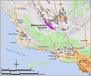
The Midway-Sunset Oil Field is a large oil field in Kern County, San Joaquin Valley, California in the United States. It is the largest known oilfield in California and the third largest in the United States.

The South Belridge Oil Field is a large oil field in northwestern Kern County, San Joaquin Valley, California, about forty miles west of Bakersfield. Discovered in 1911, and having a cumulative production of over 1,500 million barrels (240,000,000 m3) of oil at the end of 2008, it is the fourth-largest oil field in California, after the Midway-Sunset Oil Field, Kern River Oil Field, and Wilmington Oil Field, and is the sixth-most productive field in the United States. Its estimated remaining reserves, as of the end of 2008, were around 494 million barrels (78,500,000 m3), the second-largest in the state, and it had 6,253 active wells. The principal operator on the field was Aera Energy LLC, a joint venture between Royal Dutch Shell and ExxonMobil. Additionally, the field included the only onshore wells in California owned and operated by ExxonMobil.
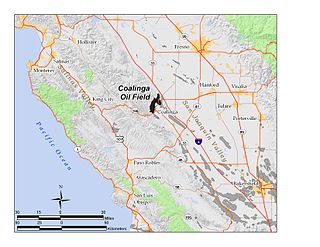
The Coalinga Oil Field is a large oil field in western Fresno County, California, in the United States. It surrounds the town of Coalinga, about halfway between Los Angeles and San Francisco, to the west of Interstate 5, at the foot of the Diablo Range. Discovered in the late 19th century, it became active around 1890, and is now the eighth-largest oil field in California, with reserves totaling approximately 58 million barrels (9,200,000 m3), and over 1,600 active oil wells. The principal operators on the field, as of 2008, were Chevron Corp. and Aera Energy LLC.

The Buena Vista Oil Field, formerly the Naval Petroleum Reserve No. 2 (NPR-2) is a large oil field in Kern County, San Joaquin Valley, California in the United States. Discovered in 1909, and having a cumulative production of approximately 667 million barrels (106,000,000 m3), it is the tenth-largest oil field in California. As of year end 2006 the field had a total reserve of only about one percent of its original oil, and having produced a mere 713,000 barrels (113,400 m3). Since, the field has gone through a revitalization. Crimson Resources initiated a waterflood in the Etchegoin Formation, saw good response and sold the asset to Occidental Petroleum. CRC continued the development of the waterflood, but also tested the viability of the Monterey Formation. The Monterey Formation at Buena Vista has proven to be a viable target and is currently being developed.

The Cymric Oil Field is a large oil field in Kern County, California, in the United States. While only the 14th-largest oil field in California in total size, in terms of total remaining reserves it ranks fifth, with the equivalent of over 119 million barrels (18,900,000 m3) still in the ground. Production at Cymric has been increasing faster than at any other California oil field.

The San Ardo Oil Field is a large oil field in Monterey County, California, in the United States. It is in the Salinas Valley, about five miles (8 km) south of the small town of San Ardo, and about 20 miles (32 km) north of Paso Robles. With an estimated ultimate recovery of 532,496,000 barrels (84,660,100 m3) of oil, it is the eighth-largest producing oil field in California, and of the top 20 California oil fields in size, it is the most recent to be discovered (1947). As of the end of 2006, the principal operators of the field were Chevron Corp. and Aera Energy LLC.

The Monterey Formation is an extensive Miocene oil-rich geological sedimentary formation in California, with outcrops of the formation in parts of the California Coast Ranges, Peninsular Ranges, and on some of California's off-shore islands. The type locality is near the city of Monterey, California. The Monterey Formation is the major source-rock for 37 to 38 billion barrels of oil in conventional traps such as sandstones. This is most of California's known oil resources. The Monterey has been extensively investigated and mapped for petroleum potential, and is of major importance for understanding the complex geological history of California. Its rocks are mostly highly siliceous strata that vary greatly in composition, stratigraphy, and tectono-stratigraphic history.

The Kettleman North Dome Oil Field is a large oil and gas field in Kings and Fresno counties, California. Discovered in 1928, it is the fifteenth largest field in the state by total ultimate oil recovery, and of the top twenty oil fields, it is the closest to exhaustion, with less than one-half of one percent of its original oil remaining in place.

The McKittrick Oil Field is a large oil and gas field in western Kern County, California. The town of McKittrick overlies the northeastern portion of the oil field. Recognized as an oil field in the 19th century, but known by Native Americans for thousands of years due to its tar seeps, the field is ranked 19th in California by total ultimate oil recovery, and has had a cumulative production of over 303 million barrels (48,200,000 m3) of oil. The principal operators of the field as of 2008 were Chevron Corp. and Aera Energy LLC, but many independent oil exploration and production companies were also active on the field. The California Department of Oil, Gas and Geothermal Resources (DOGGR) estimates approximately 20 million recoverable barrels of oil remain in the ground.

The Kern Front Oil Field is a large oil and gas field in the lower Sierra Nevada foothills in Kern County, California. Discovered in 1912, and with a cumulative production of around 210 million barrels (33,000,000 m3) of oil, it ranks 29th in size in the state, and is believed to retain approximately ten percent of its original oil, according to the official estimates of the California Department of Oil, Gas, and Geothermal Resources (DOGGR). It is adjacent to the much larger Kern River Oil Field, which is to the southeast, and the Mount Poso Oil Field to the north.

The North Belridge Oil Field is a large oil field along California State Route 33 in the northwestern portion of Kern County, California, about 45 miles west of Bakersfield. It is contiguous with the larger South Belridge Oil Field to the southeast, in a region of highly productive and mature fields. Discovered in 1912, it has had a cumulative production of 136,553,000 barrels (21,710,200 m3) of oil, and retains 27,443,000 barrels (4,363,100 m3) in reserve, as of the end of 2006, making it the 40th largest oil field in the state.
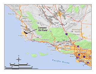
The Lompoc Oil Field is a large oil field in the Purisima Hills north of Lompoc, California, in Santa Barbara County. Discovered in 1903, two years after the discovery of the Orcutt Oil Field in the Solomon Hills, it is one of the oldest oil fields in northern Santa Barbara County, and one of the closest to exhaustion, reporting only 1.7 million barrels (270,000 m3) of recoverable oil remaining out of its original 50 million barrels (7,900,000 m3) as of the end of 2008. Its sole operator is Sentinel Peak Resources, who acquired it from Freeport-McMoRan. In 2009, the proposed decommissioning and habitat restoration of the 3,700-acre (15 km2) field was part of a controversial and so-far unsuccessful deal between Plains, several environmental groups, Santa Barbara County, and the State of California, to allow Plains to carry out new offshore oil drilling on the Tranquillon Ridge, in the Pacific Ocean about twenty miles (32 km) southwest of the Lompoc field.

The Orcutt Oil Field is a large oil field in the Solomon Hills south of Orcutt, in Santa Barbara County, California, United States. Discovered in 1901 by William Warren Orcutt, it was the first giant field to be found in Santa Barbara County, and its development led to the boom town of Orcutt, now the major unincorporated southern suburb of Santa Maria. With a cumulative production in 2008 of 870,000 barrels (138,000 m3) of oil, it is the largest onshore producing field in Santa Barbara County.

The West Montalvo Oil Field is a large and productive oil field on the coast of Ventura County, California, in the United States, in and adjacent to the city of Oxnard, California. Discovered in 1947, it has produced approximately 43.7 million barrels (6,950,000 m3) of oil, and retains about 2.2 million barrels recoverable with current technology, in both the onshore and offshore areas. The offshore portion of the field is exploited from wells directionally drilled from onshore near McGrath Lake, from within an enclosure above the high-tide line at McGrath State Beach.

The South Mountain Oil Field is a large and productive oil field in Ventura County, California, in the United States, in and adjacent to the city of Santa Paula. Discovered in 1916, and having a cumulative production of over 158 million barrels (25,100,000 m3) of oil, it is the 37th largest oil field in California and the second largest in Ventura County. As of the beginning of 2009, it retains 316 active wells, and has an estimated 1.4 million barrels (220,000 m3) of oil remaining recoverable with current technology. Vintage Production, a subsidiary of Occidental Petroleum, was the largest operator as of 2009.
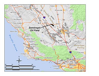
The Semitropic Oil Field is an oil and gas field in northwestern Kern County in California in the United States, within the San Joaquin Valley. Formerly known as the Semitropic Gas Field, it was discovered by the Standard Oil Company of California in 1935, and first understood to be primarily a natural gas reservoir; however, in 1956 a much deeper oil-bearing zone was discovered. The field contains the deepest oil well ever drilled in California, at 18,876 feet (5,753 m). At the end of 2008 the field still had 56 active oil wells, most of which were owned by Occidental Petroleum, and the field had an estimated 343,000 barrels of oil still recoverable with current technology.

The Guijarral Hills Oil Field is a formerly-productive oil and gas field near Coalinga on the western side of the Central Valley in central California in the United States. Discovered in 1948, and having produced 5.4 million barrels (860,000 m3) of oil during its peak year in 1950, it now has but one active oil well producing a little over a barrel of oil a day, and is very near to exhaustion, with only 343,000 recoverable barrels of oil remaining throughout its 2,515-acre (10.18 km2) extent according to the official California State Department of Conservation estimate. As of 2010, the only active operator was Longview Production Company.
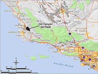
The Cat Canyon Oil Field is a large oil field in the Solomon Hills of central Santa Barbara County, California, about 10 miles southeast of Santa Maria. It is the largest oil field in Santa Barbara County, and as of 2010 is the 20th-largest in California by cumulative production.

The California oil and gas industry has been a major economic and cultural component of the US state of California for over a century. Oil production was a minor factor in the 19th century, with kerosene replacing whale oil and lubricants becoming essential to the machine age. Oil became a major California industry in the 20th century with the discovery on new fields around Los Angeles and the San Joaquin Valley, and the dramatic increase in demand for gasoline to fuel automobiles and trucks. In 1900 California pumped 4 million barrels (640,000 m3), nearly 5% of the national supply. Then came a series of major discoveries, and the state pumped 100 million bbl (16 million m3) in 1914, or 38% of the national supply. In 2012 California produced 197 million bbl (31 million m3) of crude oil, out of the total 2,375 million bbl (378 million m3) of oil produced in the US, representing 8.3% of national production. California drilling operations and oil production are concentrated primarily in Kern County, San Joaquin Valley and the Los Angeles basin.