
Montana is a state in the Mountain West division of the Western United States. It is bordered by Idaho to the west, North Dakota and South Dakota to the east, Wyoming to the south, and the Canadian provinces of Alberta, British Columbia, and Saskatchewan to the north. It is the fourth-largest state by area, the eighth-least populous state, and the third-least densely populated state. Its state capital is Helena, while the largest city is Billings. The western half of Montana contains numerous mountain ranges, while the eastern half is characterized by western prairie terrain and badlands, with smaller mountain ranges found throughout the state.

Steamboat Springs is a home rule municipality that is the county seat and the most populous municipality of Routt County, Colorado, United States. The population was 13,224 at the 2020 census. Steamboat Springs is the principal city of the Steamboat Springs, CO, Micropolitan Statistical Area, and is the largest city in northwestern Colorado.
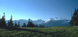
The Olympic Mountains are a mountain range on the Olympic Peninsula of the Pacific Northwest of the United States. The mountains, part of the Pacific Coast Ranges, are not especially high – Mount Olympus is the highest summit at 7,980 ft (2,432 m); however, the eastern slopes rise precipitously out of Puget Sound from sea level, and the western slopes are separated from the Pacific Ocean by the low-lying 20 to 35 km wide Pacific Ocean coastal plain. These densely forested western slopes are the wettest place in the 48 contiguous states. Most of the mountains are protected within the bounds of Olympic National Park and adjoining segments of the Olympic National Forest.

The Bitterroot Range is a mountain range and a subrange of the Rocky Mountains that runs along the border of Montana and Idaho in the northwestern United States. The range spans an area of 24,223 square miles (62,740 km2) and is named after the bitterroot, a small pink flower that is the state flower of Montana.
Fredonyer Pass, elevation 5,751 feet (1,753 m), is a high mountain pass in Lassen County, California, southwest of Susanville and southeast of Mount Lassen. It lies on the Great Basin Divide between the Feather River to the west and the Susan River and Honey Lake to the east.
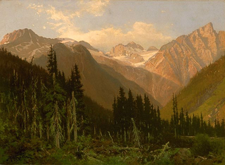
The Selkirk Mountains are a mountain range spanning the northern portion of the Idaho Panhandle, eastern Washington, and southeastern British Columbia which are part of a larger grouping of mountains, the Columbia Mountains. They begin at Mica Peak and Krell Hill near Spokane and extend approximately 320 km north from the border to Kinbasket Lake, at the now-inundated location of the onetime fur company post Boat Encampment. The range is bounded on its west, northeast and at its northern extremity by the Columbia River, or the reservoir lakes now filling most of that river's course. From the Columbia's confluence with the Beaver River, they are bounded on their east by the Purcell Trench, which contains the Beaver River, Duncan River, Duncan Lake, Kootenay Lake and the Kootenay River. The Selkirks are distinct from, and geologically older than, the Rocky Mountains. The neighboring Monashee and Purcell Mountains, and sometimes including the Cariboo Mountains to the northwest, are also part of the larger grouping of mountains known as the Columbia Mountains. A scenic highway loop, the International Selkirk Loop, encircles the southern portions of the mountain range.

The Cacapon River, located in the Appalachian Mountains of West Virginia's Eastern Panhandle region, is an 81.0-mile-long (130.4 km) shallow river known for its fishing, boating, wildlife, hunting, and wilderness scenery. As part of the Potomac River watershed, it is an American Heritage River.
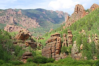
The Lost Creek Wilderness is a 119,790-acre (485 km2) wilderness area located in central Colorado in Jefferson and Park counties, south of the town of Bailey. The area is situated entirely within the boundaries of the Pike National Forest.

The Methow River is a tributary of the Columbia River in northern Washington in the United States. The river's 1,890-square-mile (4,900 km2) watershed drains the eastern North Cascades, with a population of about 5,000 people. The Methow's watershed is characterized by relatively pristine habitats, as much of the river basin is located in national forests and wildernesses. Many tributaries drain the large Pasayten Wilderness. An earlier economy based on agriculture is giving way to one based on recreation and tourism.

The Lost River is a 4.0-mile-long (6.4 km) stream in the White Mountains of New Hampshire in the United States. It is a tributary of Moosilauke Brook, part of the Pemigewasset River watershed leading to the Merrimack River.

The Lost River Range is a high mountain range of the Rocky Mountains, located in Central Idaho, in the Northwestern United States.

The Pacific Northwest Trail (PNT) is a 1,200-mile (1,900 km) hiking trail running from the Continental Divide in Montana to the Pacific Ocean on Washington's Olympic Coast. Along the way, the PNT crosses three national parks, seven national forests, and two other national scenic trails. It travels against the grain of several mountain ranges, including the Continental Divide, Whitefish Divide, Purcells, Selkirks, Kettles, Cascades, and Olympics. It was designated as the Pacific Northwest National Scenic Trail by Congress in 2009.

Lost Trail Pass is a mountain pass in the Rocky Mountains of the northwestern United States, on the border of Idaho and Montana in the Bitterroot Mountains. The pass is at an elevation of 7,014 feet (2,138 m) above sea level and is traversed by U.S. Highway 93.
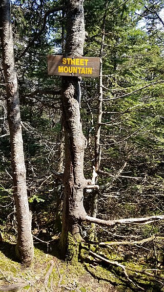
Street Mountain is a mountain located in Essex County, New York, named after Alfred Billings Street (1811–1881), a poet and New York State Librarian. The mountain is the high point of the Street Range of the Adirondack Mountains. Street's northeast ridge is Nye Mountain.
Lost Mountain is a mountain in Pushmataha County, Oklahoma, located approximately 10 miles northwest of Antlers, Oklahoma. It is a part of the Kiamichi Mountains, a subrange of the Ouachita Mountains.

Treasure Mountain, elevation 13,535 ft (4,125 m), is a summit in the Elk Mountains of western Colorado. The mountain is in the Raggeds Wilderness southeast of Marble. The massif has been the site of marble mining and a legend of lost French gold.

Mount Sniktau is a high mountain summit in the Front Range of the Rocky Mountains of North America. The 13,240-foot (4,036 m) thirteener is located in Arapaho National Forest, 1.6 miles (2.5 km) northeast of Loveland Pass in Clear Creek County, Colorado, United States.
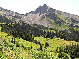
Lost Peak is a 6,515-foot-elevation (1,986-meter) mountain summit located within Olympic National Park in Jefferson County of Washington state. Part of the Olympic Mountains, Lost Peak is situated immediately northeast of Lost Pass, and is set within the Daniel J. Evans Wilderness. Precipitation runoff from the mountain drains east into the Dosewallips River, and west into the headwaters of the Lost River. Neighbors include line parent Mount Cameron, 0.8 mi (1.3 km) to the north, along with Mount Fromme and Mount Claywood, both 1.8 mi (2.9 km) to the southwest. Topographic relief is significant as the southeast aspect rises 2,500 feet above the Dosewallips River in approximately one mile. This landform's name has been officially adopted by the U.S. Board on Geographic Names. The origin of the "Lost" name is unknown, but a park ranger once described the river area as a "good place to get lost" because of the confusing and difficult travel.


