
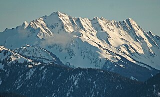
Mount Constance is a peak in the Olympic Mountains of Washington and the third highest in the range. It is the most visually prominent peak on Seattle's western skyline. Despite being almost as tall as the ice-clad Mount Olympus to the west, Mount Constance has little in the way of glaciers and permanent snow because the eastern, and particularly this northeastern, portion of the Olympics receives far less precipitation. However the narrow and steep Crystal Glacier still exists on the mountain's north face, shaded by the bulk of the main peak and with a small lake at its terminus. In addition, the treeline is higher here than mountains to the west, also hinting at the drier alpine conditions.

Mount Deception is a peak in the Olympic Mountains of Cascadia. It is in Olympic National Park on the Olympic Peninsula in the U.S. state of Washington.

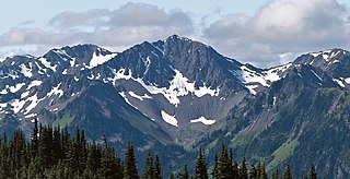
Mount Mystery is a prominent 7,639-foot (2,328-metre) mountain summit located in the Olympic Mountains in Jefferson County of Washington state. It is located within Olympic National Park on the Olympic Peninsula. Mount Mystery is the sixth-highest peak of the Olympic Mountains, after Mount Olympus, Mount Deception, Mount Constance, Mount Johnson, and Inner Constance. Its nearest higher neighbor is Mount Deception, 1.32 mi (2.12 km) to the north-northwest. Little Mystery (6,941 ft) is a subsidiary summit south of Mount Mystery.

Mount Jupiter is a 5,711-foot (1,741-meter) mountain summit in the Olympic Mountains and is located in Jefferson County of Washington state. It is situated in The Brothers Wilderness on land managed by Olympic National Forest. Mount Jupiter is easy to identify from Seattle, since it appears as the prominent peak between The Brothers and Mount Constance. Precipitation runoff from the north side of the mountain drains into the Dosewallips River, whereas the south side drains into the Duckabush River. Topographic relief is significant as the summit rises 5,100 feet above the Duckabush Valley in 1.5 miles (2.4 km). The Jupiter name was applied by the Seattle Press Expedition in an effort to link the peak with the Greco-Roman mythological names associated with Mount Olympus. Jupiter was a Roman god on Olympus. The mountain's toponym has been officially adopted by the United States Board on Geographic Names.

Mount LaCrosse, is a 6,417-foot (1,956-metre) mountain summit in the Olympic Mountains and is located in Jefferson County of Washington state. It is situated in Olympic National Park and the nearest higher peak is Mount Elk Lick, 2.54 mi (4.09 km) to the east. The Anderson massif lies 2.67 mi (4.30 km) to the north of Mount LaCrosse, and White Mountain lies 0.95 mi (1.53 km) to the southwest. Precipitation runoff from the mountain drains into tributaries of the Dosewallips River and Duckabush River.

White Mountain is a 6,378-foot (1,944-metre) mountain summit located in the Olympic Mountains, in Jefferson County of Washington state. Situated in Olympic National Park, its nearest higher neighbor is Mount LaCrosse, 0.95 mi (1.53 km) to the northeast, and an unnamed glacier lies in the north cirque between the two peaks. The Anderson massif lies 3.1 mi (5.0 km) to the north of White Mountain. Precipitation runoff from the mountain drains into tributaries of the Quinault River and Duckabush River.
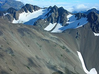
West Peak is a 7,365-foot-elevation (2,245 m) summit in the Olympic Mountains, in Jefferson County of Washington state. Rising in the center of Olympic National Park, it is the highest peak on the Anderson Massif. West Peak is the hydrographic apex of the Olympic Mountains, with precipitation runoff flowing outward to the Pacific Ocean via Quinault River, the Strait of Juan de Fuca via Elwha River, and Hood Canal via the Dosewallips River. The Eel Glacier is situated in a cirque east of the summit, and an unnamed glacier resides in the south cirque. The nearest higher peak is Mount Mystery, 7.73 miles (12.44 km) to the northeast. The first ascent of the peak was made in 1930 by E. B. Hamilton. Legend has it that the mountain's name is for Mr. West, a participant in the 1890 O'Neil Expedition, rather than for its apparent position on the Anderson Massif. The West Branch of the Quinault River was named after him in 1890.
Sentinel Peak is a 6,592-foot-high (2,009 m) mountain summit located in the Olympic Mountains, in Jefferson County of Washington state. Rising in the center of Olympic National Park, its nearest higher neighbor is Mount Fromme, 1.42 miles (2.29 km) to the northwest. Sentinels Sister is a lower 6,301-foot-high (1,921 m) companion summit situated 0.65 miles (1.05 km) to the southwest. The two peaks stand as sentinels above the Dosewalips Valley and Hayden Pass, and were possibly named by an early expedition of the Seattle Mountaineers. Precipitation runoff from the peak drains to Hood Canal via the Dosewallips River.

Mount Fricaba is a 7,139-foot-elevation (2,176 m) double summit mountain located in the Olympic Mountains, in Jefferson County of Washington state. It is situated on the shared border of Olympic National Park with Buckhorn Wilderness, and is the highest point in that wilderness, as well as the Olympic National Forest. Its nearest higher peak is Hal Foss Peak, 0.74 miles (1.19 km) to the southwest. Precipitation runoff from the peak drains east into headwaters of the Dungeness River, or west into Deception Creek which is a tributary of the Dosewallips River. The mountain's name was officially adopted in 1961 by the United States Board on Geographic Names based on usage by The Mountaineers since 1907, and inclusion in Fred Beckey's "Climber's Guide to the Cascade and Olympic Mountains of Washington" published in 1949. The first ascent of the mountain was made in 1957 by Don Bechlem and Jack Newman.

Mount Walkinshaw is a 7,378-foot mountain summit located in the Olympic Mountains, in Jefferson County of Washington state. It is situated within Olympic National Park, and is the northernmost peak in The Needles range, which is a subset of the Olympic range. Its nearest higher peak is Mount Clark, 0.9 mi (1.4 km) to the south, and Gray Wolf Ridge arcs to the northeast. Mount Walkinshaw is set in the eastern portion of the Olympic Mountains within the drainage basin of the Dungeness River. This position puts it in the rain shadow of the Olympic Range, resulting in less precipitation than Mount Olympus and the western Olympics receive.

Mount Claywood is a 6,836-foot (2,084-metre) mountain summit located within Olympic National Park in Jefferson County of Washington state. It is situated at the head of Lost River, and 15 mi (24 km) east of Mount Olympus. Its nearest higher neighbor is Mount Cameron, 2.4 mi (3.9 km) to the northeast. Other nearby peaks include Mt. Fromme, 0.58 mi (0.93 km) to the southeast, and Sentinel Peak, 2 mi (3.2 km) also to the southeast. Precipitation runoff from the mountain drains north and west into tributaries of the Elwha River, and east into Claywood Lake, thence Dosewallips River.

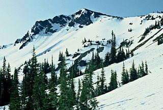
Mount Lena is a 5,995-foot-elevation mountain summit located in the Olympic Mountains, in Jefferson County of Washington state. It is situated within Olympic National Park, immediately north and 1,500 feet above the shore of Upper Lena Lake. Mt. Lena has a subsidiary peak, East Peak (5800+ ft/1768+ m), which lies northeast of the lake. Mount Bretherton lies across the lake to the south, Mount Stone is three miles to the southwest, and The Brothers approximately 3.5 miles to the northeast. Precipitation runoff from the mountain drains north to the Duckabush River, and south into the Hamma Hamma River via Lena Creek. The non-technical ascent of Mount Lena involves hiking eight miles (one-way) and 5,300 feet elevation gain via the Upper Lena Lake Trail and cross-country above the lake, with most favorable conditions from July through September. There are pleasant campsites at the lake, and the ascent to the summit takes 1.5 hour from the lake. This mountain's toponym has been officially adopted by the United States Board on Geographic Names.

Crystal Peak is a 6,896-foot-elevation (2,102-meter) mountain summit located within Olympic National Park in Jefferson County of Washington state. Crystal Peak is situated two miles north of Enchanted Valley, near the heads of Hayes River and Quinault River. Topographic relief is significant as the northeast aspect rises 3,300 feet above Hayes River in less than one mile. Precipitation runoff from the mountain drains north to the Elwha River via Hayes River and Godkin Creek. Neighbors include line parent Chimney Peak, 2.2 mi (3.5 km) to the south, and proximate parent West Peak, 2.0 mi (3.2 km) to the east. The lower slopes of the mountain are surrounded by Western Red Cedar, Sitka Spruce, Western Hemlock, Alaskan Cedar, Mountain Hemlock, and Douglas-fir of the Quinault Rainforest.
Mount Cameron is a 7,190-foot-elevation (2,192-meter) triple-summit mountain located within Olympic National Park in Jefferson County of Washington state. Mount Cameron is situated 21 miles southwest of Sequim, and set within the Daniel J. Evans Wilderness. Topographic relief is significant as the southeast aspect rises over 3,300 feet above the Dosewallips River in approximately one mile. Precipitation runoff from the mountain drains south into the Dosewallips River, north to the Gray Wolf River via Cameron Creek, and west into headwaters of Lost River. Neighbors include line parent Mount Deception, 4.5 mi (7.2 km) to the east, and proximate parent Mount Johnson, 4.5 mi (7.2 km) to the east.
McCartney Peak is a 6,784-foot-elevation (2,068-meter) mountain summit located within Olympic National Park in Jefferson County of Washington state. Part of the Olympic Mountains, McCartney Peak is situated 18 miles south of Port Angeles, and set within the Daniel J. Evans Wilderness. Topographic relief is significant as the southwest aspect rises 3,800 feet above the Lost River in approximately 1.5 mile. Precipitation runoff from the mountain drains north into headwaters of the Lillian River, east to the Gray Wolf River via Cameron Creek, and west to the Elwha River via Lost River. The nearest higher neighbor is line parent Mount Cameron, 3.1 mi (5.0 km) to the southeast.

Mount Wilder is a 5,939-foot (1,810-metre) mountain summit located near the head of the Elwha Valley, deep within Olympic National Park in Jefferson County of Washington state. Part of the Olympic Mountains, Wilder represents the southernmost peak of the Bailey Range. It is situated 8.7 miles east-southeast of Mount Olympus, and is set within the Daniel J. Evans Wilderness. Neighbors include line parent Mount Dana, 2.3 miles (3.7 km) to the northeast, and Mount Seattle rises 3.7 miles to the southwest. The headwaters of the Goldie River form on the south slope of the mountain, and precipitation runoff from the mountain drains into Goldie River and other tributaries of the Elwha River. Topographic relief is significant as the south aspect of the peak rises nearly 3,800 feet (1,160 m) in less than two miles.

Cat Peak is a 5,940-foot (1,811-metre) mountain summit within Olympic National Park in Clallam County of Washington state.
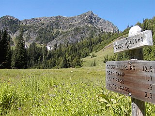
Mount Fromme is a 6,705-foot (2,044-metre) mountain summit in Olympic National Park in Jefferson County of Washington state. It is situated at the head of Dosewallips River, within the Daniel J. Evans Wilderness. The nearest higher neighbor is Mount Claywood, 0.6 mi (0.97 km) to the northwest. Other nearby peaks include Lost Peak, 1.8 mi (2.9 km) to the northeast, and Sentinel Peak, 1.4 mi (2.3 km) to the southeast. Precipitation runoff from the mountain drains east into headwaters of the Dosewallips River, and west into Hayes River, which is a tributary of the Elwha River. Topographic relief is significant as the summit rises 2,250 feet (685 m) above Dose Meadows in approximately one mile.
Adelaide Peak is a 7,300-foot-elevation mountain summit located in the Olympic Mountains, in Jefferson County of Washington state. It is situated within Olympic National Park and the Daniel J. Evans Wilderness. It is part of The Needles range, which is a subset of the Olympic range. The nearest higher peak is Mount Clark, 0.3 mi (0.48 km) to the south, and Mount Walkinshaw rises 0.66 mi (1.06 km) to the north-northwest. The peak is in the rain shadow of the Olympic Range, resulting in less precipitation than Mount Olympus and the western Olympics receive. Precipitation runoff from the mountain drains east into Royal Creek, and west into Gray Wolf River, which are both within the drainage basin of the Dungeness River. Topographic relief is significant as the east aspect rises 2,600 feet (793 m) above Royal Creek in less than one mile.

Mount Elk Lick is a 6,517-foot-elevation (1,986 meter) mountain summit located in the Olympic Mountains, in Jefferson County of Washington state. It is situated within Olympic National Park, and is set within the Daniel J. Evans Wilderness at the head of Elk Lick Creek. The nearest neighbor is Mount La Crosse, 2.54 mi (4.09 km) to the west, and the nearest higher neighbor is Diamond Mountain, 3.73 mi (6.00 km) to the north-northwest. Precipitation runoff from the mountain drains south into the Duckabush River, and north into the Dosewallips River. Topographic relief is significant as the south aspect rises over 4,300 feet (1,310 m) above the Duckabush valley in approximately one mile. The mountain is remote and an ascent can take four days and involves 46 miles of hiking.


