Mount Cameron (Washington)

Last updated
Mount Cameron
Geology ridge peaks snow BBaccus NPS photo (23109779611).jpg
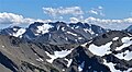
North aspect of Mt. Cameron
Highest point
Elevation 7,190 ft (2,192 m) [1]
Prominence 990 ft (302 m) [1]
Parent peak Mount Johnson (7,680 ft) [2]
Isolation 4.52 mi (7.27 km) [2]
Coordinates 47°49′31″N123°19′42″W / 47.8253625°N 123.3284517°W / 47.8253625; -123.3284517 [3]
Geography
USA Washington relief location map.jpg
Red triangle with thick white border.svg
Mount Cameron
Location of Mount Cameron in Washington
Usa edcp relief location map.png
Red triangle with thick white border.svg
Mount Cameron
Mount Cameron (the United States)
CountryUnited States
State Washington
County Jefferson
Protected area Olympic National Park
Parent range Olympic Mountains
Topo map USGS Wellesley Peak
Geology
Rock age Eocene
Climbing
Easiest route class 2 scrambling [1]

Mount Cameron is a 7,190-foot-elevation (2,192-meter) triple-summit mountain located within Olympic National Park in Jefferson County of Washington state. Mount Cameron is situated 21 miles southwest of Sequim, and set within the Daniel J. Evans Wilderness. Topographic relief is significant as the southeast aspect rises over 3,300 feet (1,000 meters) above the Dosewallips River in approximately one mile. Precipitation runoff from the mountain drains south into the Dosewallips River, north to the Gray Wolf River via Cameron Creek, and west into headwaters of Lost River. Neighbors include line parent Mount Deception, 4.5 mi (7.2 km) to the east, and proximate parent Mount Johnson, 4.5 mi (7.2 km) to the east. [2]

Contents

Etymology

This landform's toponym was officially adopted in 1969 by the U.S. Board on Geographic Names. [3] This mountain, Cameron Pass, Cameron Glaciers, Cameron Creek, and Cameron Basin are named after Amos Benson Cameron (1872–1951), an early settler of this area who homesteaded for 41 years in the Deer Park area with his wife and 14 children. [4] He pioneered the first trail into Cameron Basin.

Climate

Based on the Köppen climate classification, Mount Cameron is located in the marine west coast climate zone of western North America. [5] Weather fronts originating in the Pacific Ocean travel northeast toward the Olympic Mountains. As fronts approach, they are forced upward by the peaks (orographic lift), causing them to drop their moisture in the form of rain or snow. As a result, the Olympics experience high precipitation, especially during the winter months in the form of snowfall. [6] Because of maritime influence, snow tends to be wet and heavy, resulting in avalanche danger. During winter months weather is usually cloudy, but due to high pressure systems over the Pacific Ocean that intensify during summer months, there is often little or no cloud cover during the summer. [6] The months June through September offer the most favorable weather for viewing or climbing this mountain. [1]

Geology

The Olympic Mountains are composed of obducted clastic wedge material and oceanic crust, primarily Eocene sandstone, turbidite, and basaltic oceanic crust. [7] The mountains were sculpted during the Pleistocene era by erosion and glaciers advancing and retreating multiple times.

See also

Related Research Articles

<span class="mw-page-title-main">Mount Constance</span> Mountain in Washington (state), United States

Mount Constance is a peak in the Olympic Mountains of Washington and the third highest in the range. It is the most visually prominent peak on Seattle's western skyline. Despite being almost as tall as the ice-clad Mount Olympus to the west, Mount Constance has little in the way of glaciers and permanent snow because the eastern, and particularly this northeastern, portion of the Olympics receives far less precipitation. However the narrow and steep Crystal Glacier still exists on the mountain's north face, shaded by the bulk of the main peak and with a small lake at its terminus. In addition, the treeline is higher here than mountains to the west, also hinting at the drier alpine conditions.

<span class="mw-page-title-main">Mount Deception (Washington)</span> Mountain in Washington (state), United States

Mount Deception is a peak in the Olympic Mountains of Cascadia. It is in Olympic National Park on the Olympic Peninsula in the U.S. state of Washington.

<span class="mw-page-title-main">Mount Mystery</span> Mountain in Washington (state), United States

Mount Mystery is a prominent 7,639-foot (2,328-metre) mountain summit located in the Olympic Mountains in Jefferson County of Washington state. It is located within Olympic National Park on the Olympic Peninsula. Mount Mystery is the sixth-highest peak of the Olympic Mountains, after Mount Olympus, Mount Deception, Mount Constance, Mount Johnson, and Inner Constance. Its nearest higher neighbor is Mount Deception, 1.32 mi (2.12 km) to the north-northwest. Little Mystery (6,941 ft) is a subsidiary summit south of Mount Mystery.

<span class="mw-page-title-main">Inner Constance</span> Mountain in Washington (state), United States

Inner Constance is a summit of the Olympic Mountains and is located in Jefferson County of Washington state. It is located near the eastern edge of Olympic National Park on the Olympic Peninsula. At 7,670 feet (2,338 m), Inner Constance is the fifth-highest peak of the Olympic Mountains, after Mount Olympus, Mount Deception, Mount Constance, and Mount Johnson. Its nearest higher neighbor is Mount Constance, 0.9 mi (1.4 km) to the east. Within this nearly mile-wide separation resides a deep glacially carved canyon called "Avalanche Canyon". Precipitation runoff on the north side of the peak drains into tributaries of the Dungeness River, whereas the south side drains into tributaries of the Dosewallips River.

<span class="mw-page-title-main">Mount LaCrosse</span> Mountain in Washington (state), United States

Mount LaCrosse, is a 6,417-foot (1,956-metre) mountain summit in the Olympic Mountains and is located in Jefferson County of Washington state. It is situated in Olympic National Park and the nearest higher peak is Mount Elk Lick, 2.54 mi (4.09 km) to the east. The Anderson massif lies 2.67 mi (4.30 km) to the north of Mount LaCrosse, and White Mountain lies 0.95 mi (1.53 km) to the southwest. Precipitation runoff from the mountain drains into tributaries of the Dosewallips River and Duckabush River.

<span class="mw-page-title-main">West Peak (Jefferson County, Washington)</span> Mountain in Washington (state), United States

West Peak is a 7,365-foot-elevation (2,245 m) summit in the Olympic Mountains, in Jefferson County of Washington state. Rising in the center of Olympic National Park, it is the highest peak on the Anderson Massif. West Peak is the hydrographic apex of the Olympic Mountains, with precipitation runoff flowing outward to the Pacific Ocean via Quinault River, the Strait of Juan de Fuca via Elwha River, and Hood Canal via the Dosewallips River. The Eel Glacier is situated in a cirque east of the summit, and an unnamed glacier resides in the south cirque. The nearest higher peak is Mount Mystery, 7.73 miles (12.44 km) to the northeast. The first ascent of the peak was made in 1930 by E. B. Hamilton. Legend has it that the mountain's name is for Mr. West, a participant in the 1890 O'Neil Expedition, rather than for its apparent position on the Anderson Massif. The West Branch of the Quinault River was named after him in 1890.

<span class="mw-page-title-main">Sentinel Peak (Jefferson County, Washington)</span> Mountain in Washington (state), United States

Sentinel Peak is a 6,592-foot-high (2,009 m) mountain summit located in the Olympic Mountains, in Jefferson County of Washington state. Rising in the center of Olympic National Park, its nearest higher neighbor is Mount Fromme, 1.42 miles (2.29 km) to the northwest. Sentinels Sister is a lower 6,301-foot-high (1,921 m) companion summit situated 0.65 miles (1.05 km) to the southwest. The two peaks stand as sentinels above the Dosewalips Valley and Hayden Pass, and were possibly named by an early expedition of the Seattle Mountaineers. Precipitation runoff from the peak drains to Hood Canal via the Dosewallips River.

<span class="mw-page-title-main">Mount Fricaba</span> Mountain in Washington (state), United States

Mount Fricaba is a 7,139-foot-elevation (2,176 m) double summit mountain located in the Olympic Mountains, in Jefferson County of Washington state. It is situated on the shared border of Olympic National Park with Buckhorn Wilderness, and is the highest point in that wilderness, as well as the Olympic National Forest. Its nearest higher peak is Hal Foss Peak, 0.74 miles (1.19 km) to the southwest. Precipitation runoff from the peak drains east into headwaters of the Dungeness River, or west into Deception Creek which is a tributary of the Dosewallips River. The mountain's name was officially adopted in 1961 by the United States Board on Geographic Names based on usage by The Mountaineers since 1907, and inclusion in Fred Beckey's "Climber's Guide to the Cascade and Olympic Mountains of Washington" published in 1949. The first ascent of the mountain was made in 1957 by Don Bechlem and Jack Newman.

<span class="mw-page-title-main">Mount Pulitzer (Washington)</span> Mountain in Washington (state), United States

Mount Pulitzer, also known as Snagtooth, is a 6,283-foot (1,915-metre) mountain summit located within Olympic National Park in Jefferson County of Washington state. Mount Pulitzer is the sixth-highest peak in the Bailey Range, which is a subrange of the Olympic Mountains. Its nearest neighbor is Mount Ferry, 0.58 mi (0.93 km) to the northeast, and its nearest higher neighbor is Stephen Peak, 2.58 mi (4.15 km) to the north. Mount Olympus is set 6.8 mi (10.9 km) to the southwest. In clear weather, the mountain can be seen from the visitor center at Hurricane Ridge. Precipitation runoff from the mountain drains into tributaries of the Elwha and Hoh Rivers. The first ascent of the summit was made in 1961 by Doug Waali, Bob Wood, and Kent Heathershaw via the east ridge.

<span class="mw-page-title-main">Mount Worthington (Washington)</span> Mountain in Washington, USA

Mount Worthington is a 6,938-foot (2,115-metre) elevation double-summit mountain located in the eastern Olympic Mountains in Jefferson County of Washington state. It is set within Buckhorn Wilderness, on land managed by the Olympic National Forest. The nearest neighbor is Iron Mountain, 0.76 mi (1.22 km) to the southwest, and the nearest higher peak is Buckhorn Mountain, 1.3 mi (2.1 km) to the southwest. Precipitation runoff from Mount Worthington drains south into the Big Quilcene River, or north into Copper Creek which is a tributary of the Dungeness River. This mountain was first known as Copper Peak, but was renamed by Jack Christensen for the William J. Worthington family, pioneers of nearby Quilcene. Copper was mined in the Tubal Cain mine at the northern base of this mountain in the early 1900s. In the same vicinity of the abandoned mine are the remains of a modified B-17 plane that crashed on January 19, 1952, when returning from a search-and-rescue mission.

<span class="mw-page-title-main">Mount Claywood</span> Mountain in Washington (state), United States

Mount Claywood is a 6,836-foot (2,084-metre) mountain summit located within Olympic National Park in Jefferson County of Washington state. It is situated at the head of Lost River, and 15 mi (24 km) east of Mount Olympus. Its nearest higher neighbor is Mount Cameron, 2.4 mi (3.9 km) to the northeast. Other nearby peaks include Mt. Fromme, 0.58 mi (0.93 km) to the southeast, and Sentinel Peak, 2 mi (3.2 km) also to the southeast. Precipitation runoff from the mountain drains north and west into tributaries of the Elwha River, and east into Claywood Lake, thence Dosewallips River.

<span class="mw-page-title-main">Athena (Olympic Mountains)</span> Mountain in Washington (state), United States

Athena is a 7,365-foot-elevation (2,245 meter) mountain summit located within Olympic National Park in Jefferson County of Washington state. Athena is situated at the head of the Hoh Glacier, and the Hubert Glacier lies below the west aspect. Its neighbors include Mount Olympus, 1.7 mi (2.7 km) to the northwest, and Aries 1.7 mi (2.7 km) to the northeast. Athena has subpeaks "Athena II" (7,259 ft), and "Athena's Owl" (7,000 ft). Precipitation runoff from the mountain drains into the Queets and Hoh Rivers, with Athena being the highest point within the Queets drainage basin.

<span class="mw-page-title-main">McCartney Peak</span> Mountain in Washington (state), United States

McCartney Peak is a 6,784-foot-elevation (2,068-meter) mountain summit located within Olympic National Park in Jefferson County of Washington state. Part of the Olympic Mountains, McCartney Peak is situated 18 miles south of Port Angeles, and set within the Daniel J. Evans Wilderness. Topographic relief is significant as the southwest aspect rises 3,800 feet above the Lost River in approximately 1.5 mile. Precipitation runoff from the mountain drains north into headwaters of the Lillian River, east to the Gray Wolf River via Cameron Creek, and west to the Elwha River via Lost River. The nearest higher neighbor is line parent Mount Cameron, 3.1 mi (5.0 km) to the southeast.

<span class="mw-page-title-main">Mount Seattle (Washington)</span> Mountain in Washington (state), United States

Mount Seattle is a 6,246-foot (1,904-metre) mountain summit deep within Olympic National Park in Jefferson County of Washington state. Part of the Olympic Mountains, Mount Seattle is situated 7.5 miles southeast of Mount Olympus, and set within the Quinault Rainforest and Daniel J. Evans Wilderness. The nearest higher neighbor is Mount Meany, 1.65 miles (2.66 km) to the north-northwest, and Mount Noyes rises one mile to the northwest. Precipitation runoff from the mountain drains north into headwaters of the Elwha River, and south into tributaries of the Quinault River. Topographic relief is significant as the northeast aspect of the peak rises over 3,800 feet (1,200 m) above the Elwha valley in approximately 1.5-mile. Low Divide forms the saddle between Mt. Seattle and Mount Christie.

<span class="mw-page-title-main">Mount Wilder</span> Mountain in Washington (state), United States

Mount Wilder is a 5,939-foot (1,810-metre) mountain summit located near the head of the Elwha Valley, deep within Olympic National Park in Jefferson County of Washington state. Part of the Olympic Mountains, Wilder represents the southernmost peak of the Bailey Range. It is situated 8.7 miles east-southeast of Mount Olympus, and is set within the Daniel J. Evans Wilderness. Neighbors include line parent Mount Dana, 2.3 miles (3.7 km) to the northeast, and Mount Seattle rises 3.7 miles to the southwest. The headwaters of the Goldie River form on the south slope of the mountain, and precipitation runoff from the mountain drains into Goldie River and other tributaries of the Elwha River. Topographic relief is significant as the south aspect of the peak rises nearly 3,800 feet (1,160 m) in less than two miles.

<span class="mw-page-title-main">Cat Peak</span> Mountain in Washington (state), United States

Cat Peak is a 5,940-foot (1,811-metre) mountain summit within Olympic National Park in Clallam County of Washington state.

<span class="mw-page-title-main">Mount Fromme (Washington)</span> Mountain in Washington (state), United States

Mount Fromme is a 6,705-foot (2,044-metre) mountain summit in Olympic National Park in Jefferson County of Washington state. It is situated at the head of Dosewallips River, within the Daniel J. Evans Wilderness. The nearest higher neighbor is Mount Claywood, 0.6 mi (0.97 km) to the northwest. Other nearby peaks include Lost Peak, 1.8 mi (2.9 km) to the northeast, and Sentinel Peak, 1.4 mi (2.3 km) to the southeast. Precipitation runoff from the mountain drains east into headwaters of the Dosewallips River, and west into Hayes River, which is a tributary of the Elwha River. Topographic relief is significant as the summit rises 2,250 feet (685 m) above Dose Meadows in approximately one mile.

<span class="mw-page-title-main">Lost Peak (Jefferson County, Washington)</span> Mountain in Washington (state), United States

Lost Peak is a 6,515-foot-elevation (1,986-meter) mountain summit located within Olympic National Park in Jefferson County of Washington state. Part of the Olympic Mountains, Lost Peak is situated immediately northeast of Lost Pass, and is set within the Daniel J. Evans Wilderness. Precipitation runoff from the mountain drains east into the Dosewallips River, and west into the headwaters of the Lost River. Neighbors include line parent Mount Cameron, 0.8 mi (1.3 km) to the north, along with Mount Fromme and Mount Claywood, both 1.8 mi (2.9 km) to the southwest. Topographic relief is significant as the southeast aspect rises 2,500 feet above the Dosewallips River in approximately one mile. This landform's name has been officially adopted by the U.S. Board on Geographic Names. The origin of the "Lost" name is unknown, but a park ranger once described the river area as a "good place to get lost" because of the confusing and difficult travel.

<span class="mw-page-title-main">Adelaide Peak (Washington)</span> Mountain in Washington, USA

Adelaide Peak is a 7,300-foot-elevation mountain summit located in the Olympic Mountains, in Jefferson County of Washington state. It is situated within Olympic National Park and the Daniel J. Evans Wilderness. It is part of The Needles range, which is a subset of the Olympic range. The nearest higher peak is Mount Clark, 0.3 mi (0.48 km) to the south, and Mount Walkinshaw rises 0.66 mi (1.06 km) to the north-northwest. The peak is in the rain shadow of the Olympic Range, resulting in less precipitation than Mount Olympus and the western Olympics receive. Precipitation runoff from the mountain drains east into Royal Creek, and west into Gray Wolf River, which are both within the drainage basin of the Dungeness River. Topographic relief is significant as the east aspect rises 2,600 feet (793 m) above Royal Creek in less than one mile.  

<span class="mw-page-title-main">Mount Elk Lick</span> Mountain in Washington (state), United States

Mount Elk Lick is a 6,517-foot-elevation (1,986 meter) mountain summit located in the Olympic Mountains, in Jefferson County of Washington state. It is situated within Olympic National Park, and is set within the Daniel J. Evans Wilderness at the head of Elk Lick Creek. The nearest neighbor is Mount La Crosse, 2.54 mi (4.09 km) to the west, and the nearest higher neighbor is Diamond Mountain, 3.73 mi (6.00 km) to the north-northwest. Precipitation runoff from the mountain drains south into the Duckabush River, and north into the Dosewallips River. Topographic relief is significant as the south aspect rises over 4,300 feet (1,310 m) above the Duckabush valley in approximately one mile. The mountain is remote and an ascent can take four days and involves 46 miles of hiking.

References

  1. 1 2 3 4 Mount Cameron, climbersguideolympics.com
  2. 1 2 3 "Cameron, Mount - 7,190' WA". listsofjohn.com. Retrieved 2021-12-25.
  3. 1 2 "Mount Cameron". Geographic Names Information System . United States Geological Survey, United States Department of the Interior . Retrieved 2021-12-25.
  4. Parratt, Smitty (1984). Gods and Goblins: A Field Guide to Place Names of Olympic National Park (1st ed.).
  5. Peel, M. C.; Finlayson, B. L.; McMahon, T. A. (2007). "Updated world map of the Köppen−Geiger climate classification". Hydrol. Earth Syst. Sci. 11: 1633–1644. ISSN   1027-5606.
  6. 1 2 McNulty, Tim (2009). Olympic National Park: A Natural History. Seattle, Washington: University of Washington Press.
  7. Alt, D.D.; Hyndman, D.W. (1984). Roadside Geology of Washington. pp. 249–259. ISBN   0-87842-160-2.