
The Bernese Mountain Dog is a large-sized breed of dog, one of the four breeds of Sennenhund-type dogs from the Swiss Alps. The name Sennenhund is derived from the German Senne and Hund (hound/dog), as they accompanied the alpine herders and dairymen called Senn. Berner refers to the area of the breed’s origin, in the canton of Bern. This mountain dog was originally kept as a general farm dog. Large Sennenhunde in the past were also used as draft animals, pulling carts. The breed was officially established in 1907. In 1937, the American Kennel Club recognized it; today, the club classifies it as a member of the Working Group.

The canton of Bern or Berne is the second largest of the 26 Swiss cantons by both surface area and population. Located in west-central Switzerland, it borders the canton of Jura and the canton of Solothurn to the north. To the west lie the canton of Neuchâtel, the canton of Fribourg and canton of Vaud. To the south lies the canton of Valais. East of the canton of Bern lie the cantons of Uri, Nidwalden, Obwalden, Lucerne and Aargau.

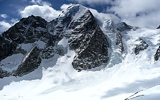
The Finsteraarhorn is the highest mountain in the Bernese Alps in Switzerland and the most prominent peak of Switzerland. The Finsteraarhorn is the ninth-highest mountain and third-most prominent peak in the Alps. In 2001 the whole massif and surrounding glaciers were designated as part of the Jungfrau-Aletsch World Heritage Site.

The Grünhorn is a mountain in the Bernese Alps range of the Swiss Alps. It is located on the ridge between the two largest glaciers of the Alps: the Aletsch Glacier to the west and the Fiescher Glacier to the east. To the south lies the Gross Wannenhorn and, to the north, the Gross Fiescherhorn.

The Berner Oberland, is the higher part of the canton of Bern, Switzerland, in the southern end of the canton, and one of the canton's five administrative regions.

The Schreckhorn is a mountain in the Bernese Alps. It is the highest peak located entirely in the canton of Berne. The Schreckhorn is the northernmost Alpine four-thousander and the northernmost summit rising above 4,000 metres in Europe.

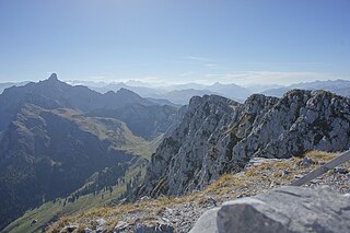
The Schynige Platte is a small mountain ridge and a viewpoint in the Bernese Highlands and belongs to the Schwarzhorn group. The mountain range consists of three peaks: Gumihorn, Tuba, and the closest summit next to the viewpoint, Geiss. The viewpoint lies at an altitude of about 2,000 metres (7,000 ft), at the western end of a prominent ridge of the Schwarzhorn group, which separates the valley of the Schwarze Lütschine from Lake Brienz.

The Wildhorn is a mountain of the Alps, straddling the border between the Swiss cantons of Bern and Valais. At 3,248 metres (10,656 ft) above sea level, it is the highest summit of the Bernese Alps west of the Gemmi Pass. It forms a large glaciated massif, about 10 km wide, extending between the Sanetsch Pass and the Rawil Pass. Along with the Muverans, the Diablerets and the Wildstrubel, the Wildhorn is one the four distinct mountain massifs of the Bernese Alps that lie west of the Gemmi Pass. The massif of the Wildhorn is at the centre between the valleys of the Saane, Simme and the Rhone (Valais). It comprises several distinct summits, including the Arpelistock, Le Sérac, the Geltenhorn, the Sex Noir, the Sex Rouge, the Schnidehorn and the Six des Eaux Froides. The main crest is between the glaciers named Tungelgletscher and Glacier du Wildhorn. South of the main summit is the almost equally high summit of Mont Pucel. The Wildhorn is surrounded by several large mountain lakes: the Lac de Sénin, the Lauenensee, the Iffigsee, the Lac de Tseuzier and the Lac des Audannes. The Tungelgletscher, on the north-east face, was measured as 1.9 km in length in 1973.
The Nesthorn is a mountain in the Bernese Alps. It is located in the Swiss canton of Valais north of Brig. The mountain lies between the Oberaletsch Glacier on the north and east side and the Gredetschtal on the south side. It is part of the subrange of the Bernese Alps that culminates at the Aletschhorn.

The Bärglistock is a mountain of the Bernese Alps, located east of Grindelwald in the Bernese Oberland. The mountain is the tripoint between the valleys of the Upper Grindelwald Glacier, the Unteraar Glacier and the Gauli Glacier.
The Mutthorn is a mountain of the Bernese Alps, overlooking the Kander Glacier in the Bernese Oberland. It lies between the valleys of Kandersteg (west) and Lauterbrunnen (east).
The Spillgerte is a mountain of the Bernese Alps, located east of Zweisimmen in the Bernese Oberland. The mountain lies between the valleys of Diemtigen and Simmental, a few kilometres north of the Albristhorn. It is composed of several summits of which the Hinderi Spillgerte is the highest.
The Rauflihorn is a mountain of the Bernese Alps, located east of St. Stephan in the Bernese Oberland, Switzerland.
The Ärmighorn is a mountain of the Bernese Alps, located east of Kandergrund in the Bernese Oberland. It lies north of the Dündenhorn, on the range between the Kandertal and the Kiental.
The Wätterlatte is a mountain of the Bernese Alps, located east of Reichenbach im Kandertal in the Bernese Oberland. It lies on the range west of the Schwalmere, that separates the Suldtal from the Kiental.
The Bietenhorn is a mountain of the Bernese Alps, located north of Mürren in the Bernese Oberland. It lies north-east of the Schilthorn, on the range between the Soustal and the main Lauterbrunnen valley.
The Alplistock is a mountain of the Bernese Alps, located west of Handegg in the Bernese Oberland. It lies east of the Diamantstock, on the range between the valley of the Grueben Glacier and the Bächlital.
The Tschingelspitz is a mountain of the Bernese Alps, located south of Mürren in the Bernese Oberland. It lies east of the higher Gspaltenhorn.
The Hundsrügg is a mountain of the Bernese Alps, located west of Zweisimmen in the Bernese Oberland. It is the highest point of the chain south of the Jaun Pass and east of the Gastlosen.


