Louisiana State Route 7-X

Last updated

Louisiana 7-X (1924).svg

Suffixed routes of State Route 7
Highway system
  • Louisiana State Highway System

Louisiana State Route 7 had multiple suffixed routes, designating bypassed alignments of the highway. They are listed below in order from west to east.

Contents

Elton (LA 7-D)

Louisiana 7-D (1924).svg
State Route 7-D
Location Elton
Length1.40 mi (2.25 km)
Existed1955

Louisiana State Route 7-D (LA 7-D) spanned 1.90 miles (3.06 km) from west to east and was known as Yoakum Street and Kennedy Road. It served as the older alignment of LA 7 through Elton.

Junction list

The entire highway is in Elton, Jefferson Davis Parish.

mikmDestinationsNotes
0.00.0US 190 (1948).svgLouisiana 7 (1924).svg US 190  / SR 7
1.42.3Louisiana 25 (1924).svg SR 25  Oberlin
1.000 mi = 1.609 km; 1.000 km = 0.621 mi

Lawtell (LA 7-E)

Louisiana 7-E (1924).svg
State Route 7-E
Location Lawtell
Length3.90 mi (6.28 km)
Existed1955

Louisiana State Route 7-E (LA 7-E) spanned 3.90 miles (6.28 km) from west to east and was known as Summer Road. It served as the older alignment of LA 7 near Lawtell.

Junction list

The entire highway is in Lawtell, Saint Landry Parish.

mikmDestinationsNotes
0.00.0US 190 (1948).svgLouisiana 7 (1924).svg US 190  / SR 7
3.96.3US 190 (1948).svgLouisiana 7 (1924).svg US 190  / SR 7
1.000 mi = 1.609 km; 1.000 km = 0.621 mi

Opelousas (LA 7-H)

Louisiana 7-H (1924).svg
State Route 7-H
Location Opelousas
Length2.10 mi (3.38 km)
Existed1955

Louisiana State Route 7-H (LA 7-H) spanned 2.10 miles (3.38 km) from west to east. It served as the older alignment of LA 7 near Opelousas.

Junction list

The entire highway is in Opelousas, Saint Landry Parish.

mikmDestinationsNotes
0.00.0US 190 (1948).svgLouisiana 7 (1924).svg US 190  / SR 7
1.21.9US 190 (1948).svgLouisiana 7 (1924).svg US 190  / SR 7
2.13.4End state maintenance
1.000 mi = 1.609 km; 1.000 km = 0.621 mi

Krotz Springs (LA 7-D)

Louisiana 7-D (1924).svg
State Route 7-D
Location Krotz Springs
Length1.20 mi (1.93 km)
Existed1944

Louisiana State Route 7-D (LA 7-D) spanned 1.20 miles (1.93 km) from west to east. It served as the older alignment of LA 7 east of Krotz Springs, being bypassed by a newer alignment through the Morganza Spillway. It last appeared on maps in 1944.

Junction list

The entire highway is in East Krotz Springs, Pointe Coupee Parish.

mikmDestinationsNotes
0.00.0Begin state maintenance at railroad bridge
3.96.3End state maintenance in Morganza Spillway
1.000 mi = 1.609 km; 1.000 km = 0.621 mi

Baton Rouge (LA 7-D)

Louisiana 7-D (1924).svg
State Route 7-D
Location Baton Rouge
Length7.40 mi (11.91 km)
Existed1955

Louisiana State Route 7-D (LA 7-D) spanned 7.40 miles (11.91 km) from west to east and was known as Old Hammond Highway. It served as the older alignment of LA 7 through Baton Rouge, being bypassed by the newer Florida Boulevard project. The road is still known as Old Hammond Highway to this day.

Junction list

The entire highway is in Baton Rouge, East Baton Rouge Parish.

mikmDestinationsNotes
0.00.0Louisiana 1 (1924).svg SR 1 (Jefferson Highway)
1.72.7US 61 (1948).svg US 61 (Airline Highway)
7.411.9US 190 (1948).svgLouisiana 7 (1924).svg US 190  / SR 7  Denham Springs
1.000 mi = 1.609 km; 1.000 km = 0.621 mi

Denham Springs (LA 7-E)

Louisiana 7-E (1924).svg
State Route 7-E
Location Denham Springs
Length1.70 mi (2.74 km)
Existed1955

Louisiana State Route 7-E (LA 7-E) spanned 1.70 miles (2.74 km) from west to east through the town of Denham Springs. It served as the older alignment of LA 7.

Junction list

The entire highway is in Denham Springs, Livingston Parish.

mikmDestinationsNotes
0.00.0US 190 (1948).svgLouisiana 7 (1924).svg US 190  / SR 7  Baton Rouge
1.72.7US 190 (1948).svgLouisiana 7 (1924).svg US 190  / SR 7  Walker
1.000 mi = 1.609 km; 1.000 km = 0.621 mi

Walker (LA 7-F)

Louisiana 7-F (1924).svg
State Route 7-F
Location Walker
Length3.50 mi (5.63 km)
Existed1955

Louisiana State Route 7-F (LA 7-F) spanned 3.50 miles (5.63 km) from west to east through the town of Walker. It served as the older alignment of LA 7.

Junction list

The entire highway is in Walker, Livingston Parish.

mikmDestinationsNotes
0.00.0US 190 (1948).svgLouisiana 7 (1924).svg US 190  / SR 7  Denham Springs
3.55.6US 190 (1948).svgLouisiana 7 (1924).svg US 190  / SR 7  Livingston
1.000 mi = 1.609 km; 1.000 km = 0.621 mi

Albany to Hammond (LA 7-D)

Louisiana 7-D (1924).svg
State Route 7-D
Locationnone
Length6.10 mi (9.82 km)
Existed1955

Louisiana State Route 7-E (LA 7-E) spanned 6.10 miles (9.82 km) from west to east to connect LA 7 with the city of Hammond. It served as the older alignment of LA 7 for the most part, with LA 366 picking up another old segment.

Junction list

ParishLocationmikmDestinationsNotes
Livingston 0.00.0Louisiana 46 (1924).svg SR 46  Springfield
Tangipahoa Hammond 6.19.8US 190 (1948).svgLouisiana 7 (1924).svg US 190  / SR 7  Albany
1.000 mi = 1.609 km; 1.000 km = 0.621 mi

Hammond to Robert (LA 7-E)

Louisiana 7-E (1924).svg
State Route 7-E
Locationnone
Length4.80 mi (7.72 km)
Existed1955

Louisiana State Route 7-E (LA 7-E) spanned 4.80 miles (7.72 km) from west to east from the town of Hammond to the community of Robert. It served as the older alignment of LA 7.

Junction list

The entire highway is in Tangipahoa Parish.

LocationmikmDestinationsNotes
Hammond 0.00.0Louisiana 7 (1924).svg SR 7
4.87.7Louisiana 7 (1924).svg SR 7
1.000 mi = 1.609 km; 1.000 km = 0.621 mi

Related Research Articles

<span class="mw-page-title-main">Interstate 12</span> Interstate Highway in Louisiana

Interstate 12 (I-12) is an intrastate Interstate Highway located entirely within the US state of Louisiana. It spans a total of 85.59 miles (137.74 km) in an east–west direction from I-10 in Baton Rouge to an interchange with both I-10 and I-59 in Slidell. Along the way, it passes through the city of Hammond, where it intersects I-55 and US Route 51 (US 51). It also serves the cities of Ponchatoula and Denham Springs, as well as the St. Tammany Parish cities of Covington and Mandeville.

<span class="mw-page-title-main">U.S. Route 171</span> United States Numbered Highway in Louisiana

U.S. Highway 171 (US 171) is a part of the United States Numbered Highway System and the only route within that system currently located entirely within the state of Louisiana. It spans 177.44 miles (285.56 km) in a north–south direction from the junction of US 90 and Louisiana Highway 14 (LA 14) in Lake Charles to the junction of US 79/US 80 and LA 3094 in Shreveport.

<span class="mw-page-title-main">U.S. Route 190</span> Highway in the United States

U.S. Route 190 (US 190) is an east–west United States Highway in Louisiana and Texas. Segments of US 190 will be upgraded to Interstate 14 (I-14); the first 24.8-mile (39.9 km) segment was opened on January 26, 2017.

<span class="mw-page-title-main">Airline Highway</span> Highway in Louisiana, United States

Airline Highway is a divided highway in the U.S. state of Louisiana, built in stages between 1925 and 1953 to bypass the older Jefferson Highway. It runs 115.6 miles (186.0 km), carrying U.S. Highway 61 from New Orleans northwest to Baton Rouge and U.S. Highway 190 from Baton Rouge west over the Mississippi River on the Huey P. Long Bridge. US 190 continues west towards Opelousas on an extension built at roughly the same time.

<span class="mw-page-title-main">Louisiana Highway 10</span> State highway in Louisiana, United States

Louisiana Highway 10 (LA 10) is a state highway located in southern Louisiana. It runs 255.51 miles (411.20 km) in an east–west direction from U.S. Highway 171 (US 171) south of Leesville to the Mississippi state line east of Bogalusa.

<span class="mw-page-title-main">Louisiana Highway 29</span> State highway in Louisiana, United States

Louisiana Highway 29 (LA 29) is a state highway located in southern Louisiana. It runs 54.09 miles (87.05 km) in a north–south direction from LA 13 north of Eunice to LA 114 west of Moreauville.

<span class="mw-page-title-main">Interstate 55 in Louisiana</span> Highway in Louisiana

Interstate 55 (I-55) is a part of the Interstate Highway System that spans 964.25 miles (1,551.81 km) from LaPlace, Louisiana, to Chicago, Illinois. Within the state of Louisiana, the highway travels 66 miles (106 km) from the national southern terminus at I-10 in LaPlace to the Mississippi state line north of Kentwood.

<span class="mw-page-title-main">Louisiana Highway 81</span> State highway in Louisiana, United States

Louisiana Highway 81 (LA 81) is a state highway located in Pointe Coupee Parish, Louisiana. It runs 8.82 miles (14.19 km) in a generally north–south direction from LA 77 in Livonia to a second junction with LA 77 in Fordoche.

<span class="mw-page-title-main">U.S. Route 51 in Louisiana</span> Section of U.S. Highway in Louisiana, United States

U.S. Highway 51 (US 51) is a part of the United States Numbered Highway System that spans 1,277 miles (2,055 km) from LaPlace, Louisiana to a point north of Hurley, Wisconsin. Within the state of Louisiana, the highway travels 69.12 miles (111.24 km) from the national southern terminus at US 61 in LaPlace to the Mississippi state line north of Kentwood.

<span class="mw-page-title-main">U.S. Route 65 in Louisiana</span> Section of U.S. Highway in Louisiana, United States

U.S. Highway 65 (US 65) is a part of the United States Numbered Highway System that spans 966 miles (1,555 km) from Clayton, Louisiana to Albert Lea, Minnesota. Within the state of Louisiana, the highway travels 100.77 miles (162.17 km) from the national southern terminus at US 425/LA 15 in Clayton to the Arkansas state line north of Lake Providence.

<span class="mw-page-title-main">Louisiana Highway 64</span> State highway in Louisiana, United States

Louisiana Highway 64 (LA 64) is a state highway located in southeastern Louisiana. It runs 20.45 miles (32.91 km) in a general east–west direction from LA 964 in Zachary to the junction of LA 16 and LA 1026 north of Denham Springs.

<span class="mw-page-title-main">U.S. Route 61/190 Business</span> Business route in Louisiana, United States

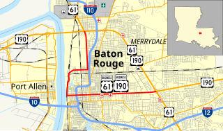
U.S. Highway 61/190 Business is a business route of both U.S. Route 61 and U.S. Route 190 in Louisiana that serves as a boulevard into downtown Baton Rouge. It spans 10.89 miles (17.53 km) in a southeast to northwest direction and it is signposted as Business 61/190, generally without directional shields. It follows parts of the former alignment of US 61/190 through Baton Rouge, which existed in downtown Baton Rouge from 1935 until 1960.

<span class="mw-page-title-main">Louisiana Highway 103</span> State highway in Louisiana, United States

Louisiana Highway 103 is a state highway in St. Landry Parish, Louisiana, United States, that spans 39.5 miles (63.6 km) in a wide semi-circle around the north side of Opelousas. The route is not bannered but runs in an overall west–east direction from U.S. Highway 190 near Lawtell to LA 31 in Leonville. Along the way, it passes through the towns of Washington and Port Barre.

<span class="mw-page-title-main">Louisiana State Route 7</span>

Louisiana State Route 7 was one of the 98 original state highways that were established in 1924. It was split into two separate segments, with the western section running in a west to east direction for 110.80 miles (178.32 km), spanning from Deweyville to the Atchafalaya River. The eastern section ran for 144.50 miles (232.55 km) from Lottie to the Mississippi state line, in a west to east direction.

References