Louisiana State Route 7

Last updated

Louisiana 7 (1924).svg

State Route 7
Route information
Existed 1924 – 1955
Section 1
Length 110.80 mi (178.32 km)
West end Texas state line near Deweyville
East end End state maintenance at Atchafalaya River
Section 2
Length 144.50 mi (232.55 km)
West endUS 190 (1948).svg US 190 in Lottie at Morganza Spillway
East endElongated circle 35.svg MS 35 at Mississippi state line
Highway system
  • Louisiana Highway System

Louisiana State Route 7 (LA 7) was one of the 98 original state highways that were established in 1924. It was split into two separate segments, with the western section running in a west to east direction for 110.80 miles (178.32 km), spanning from Deweyville to the Atchafalaya River. The eastern section ran for 144.50 miles (232.55 km) from Lottie to the Mississippi state line, in a west to east direction.

A state highway, state road, or state route is usually a road that is either numbered or maintained by a sub-national state or province. A road numbered by a state or province falls below numbered national highways in the hierarchy. Roads maintained by a state or province include both nationally numbered highways and un-numbered state highways. Depending on the state, "state highway" may be used for one meaning and "state road" or "state route" for the other.

Deweyville, Texas CDP in Texas, United States

Deweyville is a census-designated place (CDP) in Newton County, on the central eastern border of Texas, United States. The population was 1,023 at the 2010 census, down from 1,190 at the 2000 census.

Atchafalaya River river in the United States of America

The Atchafalaya River is a 137-mile-long (220 km) distributary of the Mississippi River and Red River in south central Louisiana in the United States. It flows south, just west of the Mississippi River, and is the fifth largest river in North America, by discharge. The name "Atchafalaya" comes from Choctaw for "long river", from hachcha, "river", and falaya, "long".

Contents

Route description

Old concrete pavement on abandoned stretch of LA 7, between US 71 and Krotz Springs Old US 190 between US 71 and Krotz Springs.JPG
Old concrete pavement on abandoned stretch of LA 7, between US 71 and Krotz Springs

Legislative Highway Report

Beginning on the Mississippi State Line north of Angie through Bogalusa, Covington, Hammond, Albany, Holden, Livingston, Walker, Denham Springs, Baton Rouge, Port Allen, Rosedale, Livonia, Krotz Springs, Port Barre, Opelousas, Eunice, Elton, Kinder, Fulton, De Quincy, Starks, thence to Texas line at or near Deweyville, Texas. - 1924 Louisiana Legislative Route Description

Texas to Krotz Springs

LA 7 began at the Texas state line near Deweyville, crossing the Sabine River on a swing bridge. It ran in a straight line along a railroad through the western part of the state, meeting LA 42/US 171 in Ragley and LA 24/US 165 in Kinder before entering Opelousas. LA 7 met LA 5 in Opelousas, which carried US 167, before meeting US 71 and ending in downtown Krotz Springs.

U.S. Highway 171 (US 171) is a part of the United States Numbered Highway System and the only route within that system currently located entirely within the state of Louisiana. It spans 177.44 miles (285.56 km) in a north–south direction from the junction of US 90 and Louisiana Highway 14 (LA 14) in Lake Charles to the junction of US 79/US 80 and LA 3094 in Shreveport.

U.S. Route 165 highway in the United States

U.S. Route 165 is a north–south United States highway spur of U.S. Highway 65. It currently runs for 412 miles (663 km) from U.S. Route 90 in Iowa, Louisiana north to U.S. Highway 70 in North Little Rock, Arkansas. The route passes through the states of Arkansas and Louisiana. It passes through the cities of Monroe and Alexandria in Louisiana. A segment of US 165 serves as a routing of the Great River Road within Arkansas.

Opelousas, Louisiana City in Louisiana, United States

Opelousas is a small city in and the parish seat of St. Landry Parish, Louisiana, United States. Interstate 49 and U.S. Route 190 were constructed with a junction here. The population was 22,860 at the 2000 census. In 2004 the city annexed territory and population expected to give it more than 25,000 people in total. In the 2010 census, the population was 16,634. Opelousas is the principal city for the Opelousas-Eunice Micropolitan Statistical Area, which had an estimated population of 92,178 in 2008. Opelousas is also the third-largest city in the Lafayette-Acadiana Combined Statistical Area, which has a population of 537,947.

Lottie to Mississippi

LA 7 was sliced in half with the opening of the Morganza Spillway in the same way that LA 1 was split in half with the opening of the Bonnet Carre Spillway. LA 7 followed the railroad to Livonia, where it met LA 1 and the two were paired to Port Allen. After crossing the Mississippi River in Port Allen, LA 1 turned to the south in Baton Rouge, while LA 7 picked up US 61 and US 190.

Morganza Spillway

The Morganza Spillway or Morganza Control Structure is a flood-control structure in the U.S. state of Louisiana along the western bank of the Lower Mississippi River at river mile 280, near Morganza in Pointe Coupee Parish. The spillway stands between the Mississippi and the Morganza Floodway, which leads to the Atchafalaya Basin and the Atchafalaya River in south-central Louisiana. Its purpose is to divert water from the Mississippi River during major flood events by flooding the Atchafalaya Basin, including the Atchafalaya River and the Atchafalaya Swamp. The spillway and adjacent levees also help prevent the Mississippi from changing its present course through the major port cities of Baton Rouge and New Orleans to a new course down the Atchafalaya River to the Gulf of Mexico. The Morganza Spillway, operated by the U.S. Army Corps of Engineers, was opened during the 1973 and 2011 Mississippi River floods.

Louisiana State Route 1 was one of the 98 original state highways that were established in 1924. It was signed for the Jefferson Highway, an auto trail that ran from New Orleans to Winnipeg. LA 1 curved through the entire state, spanning from Shreveport through Alexandria and Baton Rouge to New Orleans, ending south of Pointe a la Hache. It was renumbered for the most part as US 71 and US 171.

Livonia, Louisiana Town in Louisiana, United States

Livonia is a town in Pointe Coupee Parish, Louisiana, United States. The population was 1,442 at the 2010 census, up from 1,339 in 2000. It is part of the Baton Rouge Metropolitan Statistical Area. The town is home to Livonia High School. Its main police agency is the Livonia Police Department.

US 61 split from LA 7 at a traffic circle, with LA 7 carrying US 190 through the Florida Parishes. US 190 was split from LA 7 in Hammond, where LA 7 met LA 33/US 51. US 190 was paired with US 51 until the 1960s, when US 190 was shifted onto the old LA 7 alignment. LA 7 then passed through Covington and Bogalusa before ending at the Mississippi state line.

Florida Parishes Region in Louisiana, United States

The Florida Parishes, on the east side of Mississippi River — an area also known as the Northshore or Northlake region — are eight parishes in southeast Louisiana, United States, which were part of West Florida in the 18th and early 19th centuries.

Hammond, Louisiana City in Louisiana, United States

Hammond is the largest city in Tangipahoa Parish, Louisiana, United States, located 45 miles (72 km) east of Baton Rouge and 45 miles (72 km) northwest of New Orleans. Its population was 20,019 in the 2010 census. Hammond is home to Southeastern Louisiana University and is the principal city of the Hammond Metropolitan Statistical Area, which includes all of Tangipahoa Parish.

U.S. Route 51 highway in the United States

U.S. Route 51 is a major south-north United States highway that extends 1,277 miles (2,055 km) from the western suburbs of New Orleans, Louisiana, to within 150 feet (46 m) of the Wisconsin–Michigan state line. Much of the highway in northern Illinois and southern Wisconsin runs parallel to or is cosigned with Interstate 39 (I-39) and much of the route in several states also parallels the Illinois Central Railroad. The highway's northern terminus is between Hurley, Wisconsin, and Ironwood, Michigan, where it ends with a T interchange at US 2. Its southern terminus is Laplace, Louisiana, ending at US 61.

Auxiliary routes of LA 7

Louisiana State Route 7 had multiple suffixed routes, designating bypassed alignments of the highway. They are listed below in order from west to east.

Major intersections

ParishLocationmikmDestinationsNotes
Calcasieu 0.00.0Old Texas 12.svg TX 12 Western terminus
Beauregard Ragley 34.856.0US 171 (1948).svgUS 190 (1948).svgLouisiana 42 (1924).svg US 171 / US 190 west / SR 42  Deridder, Lake Charles Begin concurrency with US 190
Allen Kinder 58.293.7US 171 (1948).svgLouisiana 24 (1924).svg US 171 / SR 24  Oakdale, TO US 90
Jefferson Davis Elton 67.4108.5Louisiana 7-D (1924).svg SR 7-D
68.8110.7Louisiana 7-D (1924).svgLouisiana 25 (1924).svg SR 7-D / SR 25  Oberlin, Jennings
Saint Landry 81.0130.4Louisiana 7-E (1924).svg SR 7-E
84.7136.3Louisiana 7-H (1924).svg SR 7-H
Opelousas 89.7144.4Louisiana 40 (1924).svg SR 40  Church Point
90.3145.3Louisiana 22 (1924).svg SR 22  Ville Platte
90.7146.0US 167 (1948).svgLouisiana 5 (1924).svg US 167 / SR 5  Washington, Lafayette
91.1146.6Louisiana 25 (1924).svg SR 25  Arnaudville
107.5173.0US 71 (1948).svg US 71 north Alexandria Southern terminus of US 71
Krotz Springs 109.7176.5US 190 (1948).svg US 190 east Baton Rouge End concurrency with US 190
110.8178.3End state maintenanceEastern terminus
Gap in route
Pointe Coupee Lottie 0.00.0US 190 (1948).svg US 190 (Airline Highway)Western terminus
Livonia 3.15.0Louisiana 1 (1924).svg SR 1 north Melville Begin concurrency with LA 1
Iberville Rosedale 14.523.3Louisiana 65 (1924).svg SR 65  Grosse Tete, Plaquemine
West Baton Rouge 19.531.4Louisiana 73 (1924).svg SR 73  New Roads
Port Allen 28.045.1Louisiana 30 (1924).svg SR 30  New Roads
31.450.5Louisiana 30 (1924).svg SR 30  Plaquemine
31.550.7Toll ferry to Baton Rouge
East Baton Rouge Baton Rouge 32.552.3Louisiana 1 (1924).svg SR 1 south Gonzales End concurrency with LA 1
33.854.4US 61 (1948).svgUS 190 (1948).svgLouisiana 3 (1924).svg US 61 north / US 190 west / SR 3 northBegin concurrency with US 61/190
35.657.3Louisiana 37 (1924).svg SR 37  Greenwell Springs
38.261.5US 61 (1948).svg US 61 south Gonzales End concurrency with US 61
44.271.1Louisiana 7-D (1924).svg SR 7-D (Old Hammond Highway)
Livingston Denham Springs 45.773.5Louisiana 7-E (1924).svg SR 7-E east (South River Rd.)
48.077.2Louisiana 7-E (1924).svg SR 7-E west (Centerville St.)
49.679.8Louisiana 7-F (1924).svg SR 7-F east
Walker 53.085.3Louisiana 7-F (1924).svg SR 7-F west
Albany 69.7112.2Louisiana 46 (1924).svgLouisiana 7-D (1924).svg SR 46 to SR 7-D  Greensburg, Springfield
Tangipahoa Hammond 75.7121.8US 51 (1948).svgLouisiana 33 (1924).svgLouisiana 7-D (1924).svg US 51 north / SR 33 north / SR 7-D west Kentwood Begin concurrency with US 51/LA 33
77.0123.9US 51 (1948).svgUS 190 (1948).svgLouisiana 33 (1924).svg US 51 south / US 190 east / SR 33 south Ponchatoula End concurrency with US 51/US 190/LA 33
78.0125.5Louisiana 7-E (1924).svg SR 7-E east
Saint Tammany Covington 99.5160.1Louisiana 34 (1924).svg SR 34 north Folsom Begin concurrency with LA 34
100.0160.9Louisiana 34 (1924).svg SR 34 south Mandeville End concurrency with LA 34
100.2161.3Louisiana 58 (1924).svg SR 58  Abita Springs
Washington Bogalusa 128.3206.5Louisiana 35 (1924).svg SR 35  Franklinton Begin concurrency with LA 35
128.6207.0Louisiana 35 (1924).svg SR 35 Poplarville, Miss. Begin concurrency with LA 35
144.5232.6Elongated circle 35.svg MS 35  Columbia Eastern terminus
1.000 mi = 1.609 km; 1.000 km = 0.621 mi

Related Research Articles

Interstate 12 (I-12) is an Interstate Highway located entirely within the U.S. state of Louisiana. It spans a total of 86.65 miles (139.45 km) in an east–west direction from I-10 in Baton Rouge to an interchange with both I-10 and I-59 in Slidell. Along the way, it passes through the city of Hammond, where it intersects I-55 and US 51. It also serves the smaller cities of Denham Springs and Ponchatoula, as well as the St. Tammany Parish cities of Covington and Mandeville. Skirting the northern shore of Lake Pontchartrain, I-12 serves as a northern bypass of the New Orleans metropolitan area and as an alternate route for I-10, which serves the city of New Orleans itself.

West Baton Rouge Parish, Louisiana Parish in the United States

West Baton Rouge Parish is one of the sixty-four parishes in the U.S. state of Louisiana. As of the 2010 census, the population was 23,788. The parish seat is Port Allen. The parish was created in 1807.

The Jefferson Highway was an automobile highway stretching through the central United States from New Orleans, Louisiana, to Winnipeg, Manitoba, Canada. The Jefferson Highway was replaced with the new numbered US Highway system in the late 1920s. Portions of the highway are still named Jefferson Highway, for example: the portions that run through Jefferson Parish, Louisiana; East Baton Rouge Parish, Louisiana; Lee's Summit, Missouri; Osseo, Minnesota; and Wadena, Minnesota.

U.S. Route 71 highway in the United States

U.S. Route 71 is a major north–south United States highway that extends for over 1500 miles in the central United States. This original 1926 route has remained largely unchanged by encroaching Interstate highways. Currently, the highway's northern terminus is in International Falls, Minnesota at the Canada–US border, at the southern end of the Fort Frances-International Falls International Bridge to Fort Frances, Ontario. U.S. Route 53 also ends here. On the other side of the bridge, Trans-Canada Highway 11 is an east–west route. US 71's southern terminus is between Port Barre and Krotz Springs, Louisiana at an intersection with U.S. Route 190.

U.S. Route 190 highway in the United States

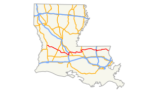
U.S. Route 190 (US 190) is an east–west United States Highway in Louisiana and Texas. Segments of US 190 will be upgraded to Interstate 14 (I-14), the first 24.8-mile (39.9 km) segment was opened on January 26, 2017.

Airline Highway highway in Louisiana

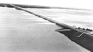
Airline Highway is a divided highway in the U.S. state of Louisiana, built in stages between 1925 and 1953 to bypass the older Jefferson Highway. It runs 115.6 miles (186.0 km), carrying U.S. Highway 61 from New Orleans northwest to Baton Rouge and U.S. Highway 190 from Baton Rouge west over the Mississippi River on the Huey P. Long Bridge. US 190 continues west towards Opelousas on an extension built at roughly the same time.

Louisiana Highway 1 highway in Louisiana

Louisiana Highway 1 (LA 1) is a state highway in Louisiana. At 431.88 miles (695.04 km), it is the longest numbered highway of any class in Louisiana. It runs diagonally across the state, connecting the oil and gas fields near the island of Grand Isle with the northwest corner of the state, north of Shreveport.

Louisiana Highway 10 highway in Louisiana

Louisiana Highway 10 (LA 10) is a state highway located in southern Louisiana. It runs 255.51 miles (411.20 km) in an east–west direction from U.S. Highway 171 (US 171) south of Leesville to the Mississippi state line east of Bogalusa.

Louisiana Highway 12 highway in Louisiana

Louisiana Highway 12 (LA 12) is a state highway located in southwestern Louisiana. It runs 34.64 miles (55.75 km) in an east–west direction from the Texas state line west of Starks to a junction with U.S. Highway 171 (US 171) and U.S. Highway 190 (US 190) in Ragley.

Louisiana Highway 25 highway in Louisiana

Louisiana Highway 25 (LA 25) is a state highway located in southeastern Louisiana. It runs 38.72 miles (62.31 km) in a north–south direction from U.S. Highway 190 (US 190) in Covington to the Mississippi state line north of Warnerton.

Louisiana Highway 81 highway in Louisiana

Louisiana Highway 81 (LA 81) is a state highway located in Pointe Coupee Parish, Louisiana. It runs 8.82 miles (14.19 km) in a generally north–south direction from LA 77 in Livonia to a second junction with LA 77 in Fordoche.

Louisiana Highway 78 highway in Louisiana

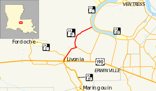
Louisiana Highway 78 (LA 78) is a state highway located in Pointe Coupee Parish, Louisiana. It runs 7.55 miles (12.15 km) in a north–south direction from a junction with U.S. Highway 190 (US 190) and LA 411 in Livonia to LA 1 in Parlange.

Elliot City, Louisiana Ghost town in Louisiana, United States

Elliot City is a ghost town that was located in Pointe Coupee Parish's 10th Ward, approximately 6 miles west of Livonia, Louisiana United States. The site of the town itself is located at coordinates 30.55614N, 91.66520W, and is covered or partially covered by the current U.S. Route 190 roadway.

Louisiana Highway 59 highway in Louisiana

Louisiana Highway 59 (LA 59) is a state highway located in St. Tammany Parish, Louisiana. It runs 11.74 miles (18.89 km) in a north–south direction from U.S. Highway 190 (US 190) in Mandeville to LA 21 north of Abita Springs.

U.S. Route 61/190 Business highway in Louisiana

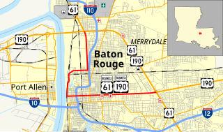
U.S. Highway 61/190 Business is a state highway in Louisiana that serves East Baton Rouge Parish. It spans 10.89 miles (17.53 km) in a southeast to northwest direction and it is bannered as Business 61/190, with no directional shields. It generally follows the 1940s-1950s alignment of US 61/190 through Baton Rouge.

References