Lowemont, Kansas

Last updated

Lowemont, Kansas
Map of Leavenworth Co, Ks, USA.png
USA Kansas location map.svg
Red pog.svg
Lowemont
Usa edcp location map.svg
Red pog.svg
Lowemont
Coordinates: 39°22′49.99″N95°3′20.88″W / 39.3805528°N 95.0558000°W / 39.3805528; -95.0558000 [1]
Country United States
State Kansas
County Leavenworth
Founded1887
Elevation
[1]
1,109 ft (338 m)
Time zone UTC-6 (CST)
  Summer (DST) UTC-5 (CDT)
Area code 913
FIPS code 20-43125 [1]
GNIS ID 478266 [1]

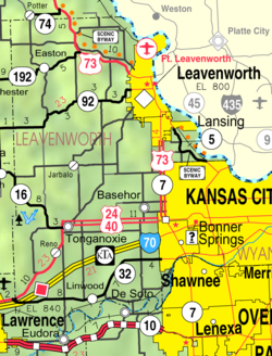
Lowemont is an unincorporated community in Leavenworth County, Kansas, United States. [1] It is part of the Kansas City metropolitan area. [2] It is located northwest of Leavenworth along U.S. Route 73 highway.

Contents

History

Early Beginnings (1887)

Growth and Prosperity (Late 19th & Early 20th Centuries)

Decline and Transformation (Mid-20th Century Onwards)

Related Research Articles

<span class="mw-page-title-main">Leavenworth County, Kansas</span> County in Kansas, United States

Leavenworth County is located in the U.S. state of Kansas and is part of the Kansas City metropolitan area. Its county seat and most populous city is Leavenworth. As of the 2020 census, the county population was 81,881. The county was named after Henry Leavenworth, a general in the Indian Wars who established Fort Leavenworth.

<span class="mw-page-title-main">Bloom, Kansas</span> Unincorporated community in Ford County, Kansas

Bloom is an unincorporated community in Ford County, Kansas, United States. Its post office closed in 1992. At a 2018 estimate, the community had a population of 94. It is located along U.S. Route 54 highway.

Stilwell is an unincorporated community in Johnson County, Kansas, United States, and part of the Kansas City metropolitan area.

<span class="mw-page-title-main">Trousdale, Kansas</span> Unincorporated community in Edwards County, Kansas

Trousdale is an unincorporated community in Lincoln Township, Edwards County, Kansas, United States. It is located along 270th Ave between S Rd and T Rd, approximately 9 miles south of Belpre, or 13 miles north of Haviland.

<span class="mw-page-title-main">Kackley, Kansas</span> Unincorporated community in Republic County, Kansas

Kackley is an unincorporated community in Republic County, Kansas, United States. It is located southeast of Courtland at Co Rd 5 and K-148 highway.

<span class="mw-page-title-main">Carlyle, Kansas</span> Unincorporated community in Allen County, Kansas

Carlyle is an unincorporated community in Allen County, Kansas, United States.

<span class="mw-page-title-main">Codell, Kansas</span> Unincorporated community in Rooks County, Kansas

Codell is an unincorporated community in Rooks County, Kansas, United States. As of the 2020 census, the population of the community and nearby areas was 49.

<span class="mw-page-title-main">Iowa Point, Kansas</span> Unincorporated community in Doniphan County, Kansas

Iowa Point is an unincorporated community in northeastern Doniphan County, Kansas, United States.

<span class="mw-page-title-main">Pierceville, Kansas</span> Unincorporated community in Finney County, Kansas

Pierceville is an unincorporated community in Finney County, Kansas, United States. As of the 2020 census, the population of the community and nearby areas was 98. It is located along U.S. Routes 50 and 400, 12 miles (19 km) southeast of Garden City.

<span class="mw-page-title-main">Berea, Nebraska</span> Census-designated place in Nebraska, United States

Berea is an unincorporated community and census-designated place in Box Butte County, in the northwestern part of the state of Nebraska in the Midwestern United States. It had a population of 41 at the 2010 census.

<span class="mw-page-title-main">Wilburton, Kansas</span> Unincorporated community in Morton County, Kansas

Wilburton is an unincorporated community in Morton County, Kansas, United States, located along U.S. Route 56 highway and the Cimarron Valley Railroad 9 miles (14 km) northeast of Elkhart.

<span class="mw-page-title-main">Cleveland, Kansas</span> Unincorporated community in Kingman County, Kansas

Cleveland is an unincorporated community in Kingman County, Kansas, United States. It is 6.5 miles (10.5 km) south of Kingman.

<span class="mw-page-title-main">Fairmount, Kansas</span> Unincorporated community in Kansas, United States

Fairmount is an unincorporated community in Leavenworth County, Kansas, United States. It is part of the Kansas City metropolitan area, and located north of the city of Basehor.

Kickapoo is an unincorporated community in Kickapoo Township, Leavenworth County, Kansas, United States. It is part of the Kansas City metropolitan area.

Wadsworth was an unincorporated community in Delaware Township, Leavenworth County, Kansas, United States. It is part of the Kansas City metropolitan area.

Fall Leaf is an unincorporated community in Leavenworth County, Kansas, United States. It is part of the Kansas City metropolitan area.

Hoge is an unincorporated community in Leavenworth County, Kansas, United States. It is part of the Kansas City metropolitan area.

<span class="mw-page-title-main">Studley, Kansas</span> Unincorporated community in Sheridan County, Kansas

Studley is an unincorporated community in Sheridan County, Kansas, United States, approximately 16 miles east of Hoxie along U.S. Route 24. It is on the eastern edge of the county in Valley Township, bordering Graham County. It was named after the Studley Royal Park, in England.

<span class="mw-page-title-main">Wilmington, Kansas</span> Unincorporated community in Wabaunsee County, Kansas

Wilmington is an unincorporated community in Wabaunsee County, Kansas, United States. It is located approximately 4 miles south of Harveyville, Kansas.

Lenape is an unincorporated community in Leavenworth County, Kansas, United States.

References

  1. 1 2 3 4 5 "Lowemont, Kansas", Geographic Names Information System , United States Geological Survey, United States Department of the Interior
  2. "Population Data and Maps | MARC".
  3. 1 2 "Kansas Post Offices, 1828-1961 (archived)". Kansas Historical Society. Archived from the original on October 9, 2013. Retrieved June 12, 2014.

Further reading