Route 21 is a state highway in northern New Jersey, running 14.35 mi (23.09 km) from the Newark Airport Interchange with U.S. Route 1/9 (US 1-9) and US 22 in Newark, Essex County to an interchange with US 46 in Clifton, Passaic County. The route is a four- to six-lane divided highway known as McCarter Highway on its southern portion in Newark that serves as a connector between the Newark and Paterson areas, following the west bank of the Passaic River for much of its length. It also serves as the main north–south highway through the central part of Newark, connecting attractions in Downtown Newark with Newark Airport. The portion of Route 21 through Newark is a surface arterial that runs alongside the elevated Northeast Corridor rail line through the southern part of the city and continues north through Downtown Newark while the portion north of Downtown Newark is a freeway. Route 21 intersects many major roads including Interstate 78 (I-78), Route 27, and I-280 in Newark, Route 7 in Belleville, and Route 3 in Clifton.

Route 23 is a state highway in the northern part of New Jersey, United States. The route runs 52.63 mi (84.70 km) from County Route 506 and County Route 577 in Verona, Essex County northwest to the border with New York at Montague Township in Sussex County, where the road continues to Port Jervis, New York, as Orange County Route 15. Route 23 heads through Essex and Passaic Counties as a two- to four-lane surface road and becomes a six-lane freeway north of a complex interchange with U.S. Route 46 and Interstate 80 in Wayne. The freeway carries Route 23 north to a concurrency with U.S. Route 202. Past the freeway portion, the route heads northwest along the border of Morris and Passaic Counties as a four- to six-lane arterial road with a wide median at places, winding through mountainous areas and crossing Interstate 287 in Riverdale. The route continues northwest through Sussex County as a mostly two-lane surface road that passes through farmland and woodland as well as the communities of Franklin, Hamburg, and Sussex before reaching the New York state line, just south of an interchange with Interstate 84 and US 6 in Port Jervis, in Montague Township near High Point State Park.
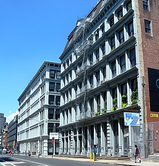
SoHo, sometimes written Soho, is a neighborhood in Lower Manhattan, New York City. Since the 1970s, the neighborhood has been the location of many artists' lofts and art galleries, and has also been known for its variety of shops ranging from trendy upscale boutiques to national and international chain store outlets. The area's history is an archetypal example of inner-city regeneration and gentrification, encompassing socioeconomic, cultural, political, and architectural developments.
Route 53 is a state highway in Morris County in the U.S. state of New Jersey. It runs 4.66 mi (7.50 km) from U.S. Route 202 in Morris Plains north to Bloomfield Avenue in Denville Township. The route, which is a two-lane undivided highway most of its length, intersects with Route 10, Interstate 80, and U.S. Route 46. For most of its length, the route runs a short distance to the east of New Jersey Transit's Morristown Line. It passes through industrial areas and wooded residential neighborhoods along its route.

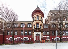
Forest Hill is a neighborhood in the city of Newark in Essex County, in the U.S. state of New Jersey. It is a pre-World War II neighborhood in the North Ward. It is bounded on the west by Branch Brook Park, on the south by Bloomfield Avenue, and on the east by both Summer and Mt. Prospect Avenues, the neighborhood of Broadway. The neighborhood's ZIP Code is 07104.

Interstate 280 (I-280) is a 17.85-mile (28.73 km) Interstate Highway in the US state of New Jersey. It provides a spur from I-80 in Parsippany–Troy Hills, Morris County, east to Newark and I-95 in Kearny, Hudson County. In Kearny, access is provided toward the Holland Tunnel and Lincoln Tunnel to New York City. The western part of the route runs through suburban areas of Morris and Essex counties, crossing the Watchung Mountains. Upon reaching The Oranges, the setting becomes more urbanized and I-280 runs along a depressed alignment before ascending again in Newark. I-280 includes a vertical-lift bridge, the William A. Stickel Memorial Bridge, over the Passaic River between Newark and East Newark/Harrison. The highway is sometimes called the Essex Freeway. I-280 interchanges with several roads, including the Garden State Parkway in East Orange and Route 21 in Newark.

Downtown Newark is the central business district of Newark in Essex County, in the U.S. state of New Jersey.

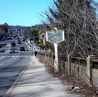
Broadway is a neighborhood within the city of Newark in Essex County, in the U.S. state of New Jersey. It is located on the west bank of the Passaic River, in Newark's North Ward, east of Forest Hill and north of Seventh Avenue. The neighborhood extends from Interstate 280 to Belleville. The term "Broadway" has only come into use recently, most Broadway residents simply refer to their area as part of the North Ward. The street itself "Broadway" was called "Washington Avenue" until the early twentieth century. Today, the area is predominantly Italian American, Puerto Rican and Dominican, with a growing population from other parts of Latin America. The New Jersey Historical Society was located here from the 1930s to 1997. The neo-classical Mutual Benefit building was constructed in the Broadway neighborhood in 1927. The district has many old brownstones in various states of repair. There are high-rise apartment buildings overlooking Branch Brook Park.
Roseville is a neighborhood in the city of Newark in Essex County, in the U.S. state of New Jersey. It borders Bloomfield and East Orange. To the neighborhood's immediate east is the Newark City Subway and Branch Brook Park. Roseville is divided into Upper Roseville north of 3rd Ave and Lower Roseville south of 3rd Ave.
The Newark-Pompton Turnpike, is a roadway in northern New Jersey that was originally a tolled turnpike. The roadway was first laid out in the mid-18th century and given its name in 1806. As originally designed, it connected Newark with the area north and west of the Pompton River in what is now Riverdale. Its south end is Broadway in Newark; its north end is the Paterson-Hamburg Turnpike. As such, it was part of an alternate route between Newark and Paterson.
Clinton Hill is a neighborhood within the south-central portion of the city of Newark in Essex County, New Jersey. it takes its name to the no-longer extant Clinton Township, of which the neighborhood was once part. Its main thoroughfare is Clinton Avenue, It is roughly bounded by Irvington to the west, Interstate 78/Weequahic to the south and Avon Avenue/Springfield/Belmont to the north. At Elizabeth Avenue it overlaps South Broad Valley.

Mount Pleasant is a neighborhood in Newark in Essex County, in the U.S. state of New Jersey. It is east of Branch Brook Park and north of the Lower Broadway neighborhood. It is named for the hill overlooking the Passaic River on which it rests.

Rockridge is a residential neighborhood and commercial district in Oakland, California. Rockridge is generally defined as the area east of Telegraph Avenue, south of the Berkeley city limits, west of the Oakland hills and north of the intersection of Pleasant Valley Avenue/51st Street and Broadway. Rockridge was listed by Money Magazine in 2002 as one of the "best places to live".

The Lents neighborhood in the Southeast section of Portland, Oregon is bordered by SE Powell Blvd. on the north, the Clackamas County line or City of Portland line on the south, SE 82nd Ave. to the west, and roughly SE 112th on the east. The NE corner overlaps with the Powellhurst-Gilbert neighborhood. In addition to Powellhurst-Gilbert on the north and east, Lents also borders Foster-Powell, Mt. Scott-Arleta, and Brentwood-Darlington on the west and Pleasant Valley on the east.

County Route 506 is a county highway in the U.S. state of New Jersey. The highway extends 10.78 miles (17.35 km) from Oak Road in Fairfield to Route 7 at the Passaic River in Belleville.

Downtown Paterson is the main commercial district of Paterson, Passaic County, in the U.S. state of New Jersey. The area is the oldest part of the city, along the banks of the Passaic River and its Great Falls. It is roughly bounded by Interstate 80, Garret Mountain Reservation, Route 19, Oliver Street, and Spruce Street on the south; the Passaic River, West Broadway, Cliff Street, North 3rd Street, Haledon Avenue, and the borough of Prospect Park on the west; and the Passaic River also to the north.
The city of San Antonio in the U.S. state of Texas is composed of a number of neighborhoods and districts, spreading out surrounding the central Downtown Area.

The Montclair-Boonton Line is a commuter rail line of New Jersey Transit Rail Operations in the United States. It is part of the Hoboken Division. The line is a consolidation of three individual lines: the former Delaware, Lackawanna & Western Railroad's Montclair Branch, which ran from Hoboken Terminal to Bay Street, Montclair. The Erie Railroad's Greenwood Lake Division, a segment from Montclair to Mountain View-Wayne, originally ran from the Jersey City Terminal to Greenwood Lake, NY, and the former Lackawanna Boonton Line ran from Hoboken to Hackettstown, New Jersey.

Remington is a neighborhood in northern Baltimore bordered to the north by Hampden, Wyman Park, and Johns Hopkins University and to the east by Charles Village. The southernmost boundary is North Avenue and the long southwestern boundary is formed by Falls Road in the I-83 corridor. The neighborhood is split between two Baltimore City Council Districts.

North Newark was a former commuter railroad train station in the Woodside section of the city of Newark, Essex County, New Jersey. Located at the intersection of Broadway and Verona Avenue, the station served trains on NJ Transit's Boonton Line, which operated at the time between Netcong and Hoboken Terminal. The station consisted of two low-level side platforms, accessible by stairs from Broadway. The next station to the east was Arlington in nearby Kearny, with the next station to the west being Rowe Street in Bloomfield.