
Glacier Peak or Dakobed is the most isolated of the five major stratovolcanoes of the Cascade Volcanic Arc in the U.S state of Washington. Located in the Glacier Peak Wilderness in Mount Baker–Snoqualmie National Forest, the volcano is visible from the west in Seattle, and from the north in the higher areas of eastern suburbs of Vancouver such as Coquitlam, New Westminster and Port Coquitlam. The volcano is the fourth tallest peak in Washington state, and not as much is known about it compared to other volcanoes in the area. Local Native Americans have recognized Glacier Peak and other Washington volcanoes in their histories and stories. When American explorers reached the region, they learned basic information about surrounding landforms, but did not initially understand that Glacier Peak was a volcano. Positioned in Snohomish County, the volcano is only 70 miles (110 km) northeast of Downtown Seattle. From locations in northern Seattle and northward, Glacier Peak is closer than the more famous Mount Rainier, but as Glacier Peak is set farther into the Cascades and almost 4,000 feet (1,200 m) shorter, it is much less noticeable than Mount Rainier.
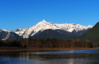
Mount Shuksan is a glaciated massif in the North Cascades National Park. Shuksan rises in Whatcom County, Washington immediately to the east of Mount Baker, and 11.6 miles (18.7 km) south of the Canada–US border. The mountain's name Shuksan is derived from the Lummi word [šéqsən], said to mean "high peak". The highest point on the mountain is a three sided peak known as Summit Pyramid.

Boulder Glacier is located on the southeast slope of Mount Baker, a stratovolcano near the Pacific coast of North America in the Cascade Range of Washington. Boulder Glacier is the sixth largest on Mount Baker with an area of 1.3 square miles (3.4 km2). It flows from the summit crater between Grant Peak and Sherman Peak to about 5,000 ft (1,500 m). It is noteworthy for retreating 1,610 ft (490 m) between 1987 and 2008, leaving newly exposed rock and soil behind.
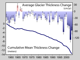
Crucial to the survival of a glacier is its mass balance or surface mass balance (SMB), the difference between accumulation and ablation. Climate change may cause variations in both temperature and snowfall, causing changes in the surface mass balance. Changes in mass balance control a glacier's long-term behavior and are the most sensitive climate indicators on a glacier. From 1980–2012 the mean cumulative mass loss of glaciers reporting mass balance to the World Glacier Monitoring Service is −16 m. This includes 23 consecutive years of negative mass balances.

Conrad Glacier is located in the Goat Rocks region of the U.S. state of Washington. Situated on the north side of 8,184-foot (2,494 m) Gilbert Peak, the glacier flows north-northeast from an elevation of 7,500 ft (2,300 m) to barren rocks and talus. A proglacial lake at 6,416 ft (1,956 m), lies where the glacier once terminated. Between 1970 and 2004, Conrad Glacier lost more than 29 ft (8.8 m) in thickness in some places and split into several separate bodies of ice.
Blue Glacier is a large glacier located to the north of Mount Olympus in the Olympic Mountains of Washington. The glacier covers an area of 1.7 sq mi (4.4 km2) and contains 580,000,000 cu ft (16,000,000 m3) of ice and snow in spite of its low terminus elevation. The glacier length has decreased from about 3.4 mi (5.5 km) in 1800 to 2.7 mi (4.3 km) in the year 2000. Just in the period from 1995 and 2006, Blue Glacier retreated 325 ft (99 m). Blue Glacier is also thinning as it retreats and between 1987 and 2009 the glacier lost 178 ft (54 m) of its depth near its terminus and between 32 and 48 ft in the uppermost sections of the glacier known as the accumulation zone.

Mount Blum, or Mount Bald, is a 7,685-foot (2,342 m) summit of the North Cascades range in Washington state, on the western edge of North Cascades National Park. It is the highest summit of a string of mountain peaks located east of Mount Shuksan and west of the Picket Range. Two small active glaciers rest on its northern flank. Mount Blum was named after John Blum, a United States Forest Service fire patrol pilot who crashed nearby in 1931.

Easton Glacier is one of the more prominent alpine glaciers on Mount Baker in the North Cascades of Washington state, United States. Named for Charles F. Easton of Bellingham, who did much to preserve the history of Mount Baker, it is positioned on the south face of the mountain and flanked by Squak and Deming Glaciers.
Kennedy Glacier is located on northwest slopes of Glacier Peak in the U.S. state of Washington. As is true with all the glaciers found on Glacier Peak, Kennedy Glacier is retreating. During the Little Ice Age, Kennedy Glacier extended down to an altitude of 4,314 ft (1,315 m) and was connected to Scimitar Glacier to the south. From about 1850 to 1952, the glacier lost 5,577 ft (1,700 m) of its length. During a cooler and wetter period from 1952 to 1984, Kennedy Glacier advanced 1,050 ft (320 m) but between 1984 and 2005, the glacier again retreated, losing 1,450 ft (440 m) of its length.
Scimitar Glacier is located on the west and northwest slopes of Glacier Peak in the U.S. state of Washington. As is true with all the glaciers found on Glacier Peak, Scimitar Glacier is retreating. During the Little Ice Age Scimitar Glacier was connected to Kennedy Glacier to the north. From about 1850 to 1946, the glacier retreated 5,250 ft (1,600 m), but advanced 1,738 ft (530 m) during a colder and wetter period lasting until about 1980. Scimitar Glacier has retreated since, but due to the thickness of the ice at the terminus, had not lost much of its length through the year 2005.
Suiattle Glacier is located in the Glacier Peak Wilderness in the U.S. state of Washington. The glacier is within Mount Baker-Snoqualmie National Forest and nearly touches Honeycomb and White River glaciers separated from them by an arête off the Kololo Peaks at its uppermost reaches. Suiattle Glacier has retreated significantly since the end of the Little Ice Age, and from approximately the years 1850 to 1924 lost 1,400 m (4,600 ft) of its length. Between 1924 and 1940, the glacier retreated an additional 900 m (3,000 ft), then during a cooler and wetter period between 1967 and 1979, the glacier had a small advance of 20 m (66 ft). Between 1979 and 2005 the glacier again retreated 178 m (584 ft) upslope.
Crystal Glacier is in North Cascades National Park in the U.S. state of Washington, on the south slopes of Mount Shuksan. Descending 1.25 mi (2.01 km) from just east of the summit of Mount Shuksan, near its origination point, Crystal Glacier is connected to the larger Sulphide Glacier to the west. Crystal Glacier descends from 8,200 to 5,800 ft, and is also connected to East Nooksack Glacier as well as Hanging Glacier near it uppermost margins. Both Crystal and Sulphide Glaciers have a series of 300-to-1,000-foot high cascades which are collectively referred to as Sulphide Basin Falls. Below these cascades lies Sulphide Lake, which empties over Sulphide Creek Falls, one of the highest waterfalls in North America with a nearly 2,200 ft (670 m) drop.
Sulphide Glacier is in North Cascades National Park in the U.S. state of Washington, on the south slopes of Mount Shuksan. Descending 1.85 mi (2.98 km) from the summit tower of Mount Shuksan, it is connected to Crystal Glacier to the east. Sulphide Glacier descends from 8,600 to 5,600 ft. Sulphide Glacier is along the route taken when Mount Shuksan was first climbed in 1906. Both Sulphide and Crystal Glaciers have a series of 300-to-1,000-foot high cascades which are collectively referred to as Sulphide Basin Falls. Below these cascades lies Sulphide Lake, which empties over Sulphide Creek Falls, one of the highest waterfalls in North America with a nearly 2,200 ft (670 m) drop.

Upper Curtis Glacier is in North Cascades National Park in the U.S. state of Washington, on the west slopes of Mount Shuksan. Upper Curtis Glacier is not connected to Lower Curtis Glacier downslope to the southwest, but is to Hanging Glacier to the north and to Sulphide Glacier to the east.

Hanging Glacier is in North Cascades National Park in the U.S. state of Washington, on the north slopes of Mount Shuksan. Hanging Glacier is connected to Crystal Glacier at its uppermost margin, and also flows into Upper Curtis Glacier. Hanging Glacier is along the route taken in the first technical ascent of Mount Shuksan in 1939.

Price Glacier is in North Cascades National Park in the U.S. state of Washington, on the northeast slopes of Mount Shuksan, below the subpeak known as Nooksack Tower. Price Glacier descends from 8,600 to 4,200 ft and is the steepest and most heavily crevasseed glacier on Mount Shuksan. The disconnected lowest portions of Price Glacier calve small icebergs into Price Lake.

Nooksack Tower is in North Cascades National Park in the U.S. state of Washington. Nooksack Tower is part of the Mount Shuksan Massif and is .75 mi (1.21 km) northeast of the main summit of Shuksan. Nooksack Tower looms to the west over Nooksack Cirque. The East Nooksack Glacier lies to the southeast, West Nooksack Glacier to the east and Price Glacier is on the north flanks of the tower. Nooksack Tower is one of the most difficult mountains to climb in the Cascade Range, with loose rock, 50-degree or greater slopes and ice ridges as well as accessibility issues and exposure, all weighing into the climbing equation. The descent may require ten or more rappels.
Price Lake is located in North Cascades National Park, in the U. S. state of Washington. Price Lake was formed by the retreat of Price Glacier, which descends from the north slopes of Mount Shuksan. Price Glacier is broken into an upper and lower section and the lower section sometimes calves small icebergs into Price Lake.

Ruth Mountain is a 7,115 ft (2,170 m) Skagit Range summit located two miles south of Hannegan Pass in the North Cascades of Washington state. The name honors Ruth Cleveland, daughter of President Grover Cleveland. This mountain's name was officially adopted in 1952 by the United States Board on Geographic Names. Ruth Mountain is situated on the shared border of North Cascades National Park and the Mount Baker Wilderness, which is part of the Mount Baker-Snoqualmie National Forest. The summit offers views of Mount Shuksan, East Nooksack Glacier, Seahpo Peak, Nooksack Tower, Icy Peak, Mount Sefrit, Mineral Mountain, and the Picket Range. The melting and receding Ruth Glacier on the north slope of Ruth creates the headwaters for the Chilliwack River. Precipitation runoff also finds its way into the Nooksack and Baker Rivers.

