The Oropom were the aboriginal inhabitants of much of Karamoja in Uganda, Mt. Elgon area and West Pokot, Trans Nzoia and Turkana regions in Kenya. Their descendants were largely assimilated into various communities present in their former territories, including the Iteso, Karamojong, Pokot, Turkana and Bukusu. They are or were found in scattered pockets between the Turkwel River, Chemorongit Mountains and Mt. Elgon. One report indicates that they formerly spoke the unclassified Oropom language.

Kitgum District is a district in Northern Uganda. It is named after its 'chief town' of Kitgum, where the district headquarters is located. It has suffered many deaths and social disruption resulting from the 20-year civil war within the region during the late 20th century. The government moved tens of thousands of residents were moved to internally displaced persons camps for their protection, where they were subject to raids by the rebels and also harsh conditions, including disease.
Moroto District is a district in the Northern Region of Uganda. The town of Moroto is the site of the district headquarters.

Ateker, or ŋaTekerin, is a common name for the closely related Jie, Karamojong, Turkana, Toposa, Nyangatom and Teso peoples and their languages. These ethnic groups inhabit an area across Uganda and Kenya. Itung'a and Teso have been used among ethnographers, while the term Teso-Turkana is sometimes used for the languages, which are of Eastern Nilotic stock. Ateker means 'clan' or 'tribe' in the Teso language. In the Lango language, the word for clan is atekere.
Karamoja sub-region, commonly known as Karamoja, is a region in Uganda.

Nakapiripirit is a town in the Nakapiripirit District of the Northern Region of Uganda. It is the seat of the district headquarters. The town is an administrative unit of the district, at the level of a sub-county; one of the eight sub-counties in the district.

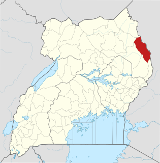
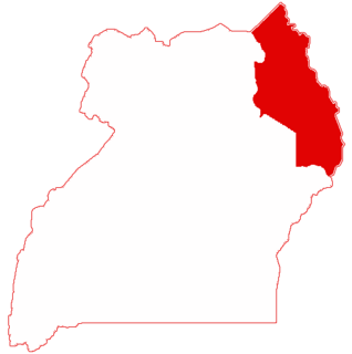
Kaabong District is a district in the Northern Region of Uganda. The district headquarters are in the town of Kaabong.
The Uganda People's Army (UPA) was a rebel group recruited primarily from the Iteso people of Uganda that was active between 1987 and 1992. The UPA was composed mostly of former soldiers in the special forces of the Uganda National Liberation Army and opposed the National Resistance Army (NRA) government of Yoweri Museveni, who took power in January 1986. Reaching a height after the widespread cattle raid by Karamojong in 1987, the UPA rebellion was eventually ended through the mediation of the Teso Commission.
Simon Lokodo is a Ugandan politician who has served as Minister of State for Ethics & Integrity in the Office of the President of Uganda since 2011. Previously he was the Minister of State for Industry from 2009 to 2011. He has also been the elected Member of Parliament representing Dodoth County, Kaabong District since 2006.
Abim District is a district in Northern Uganda. It's named after its 'chief town', Abim, where the district headquarters are located.

Kaabong is a town in the Northern Region of Uganda. It is the chief municipal, administrative and commercial center of Kaabong District, and the district headquarters are located there.

Amudat District is a district in Northern Uganda. Like most other Ugandan districts, it is named after its 'chief town', Amudat, where the district headquarters are located.

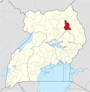
Napak District is a district in Northern Uganda. It is named after Mount Napak, and its headquarters is at Lokitede.

The Didinga Hills are an upland area in Namorunyang State of South Sudan, lying mainly within Budi County. Before the reorganisation of states, it was a part of Eastern Equatoria. They are named for the Didinga people who live in the region. The Didinga Hills have rich and fertile soil that is used for cultivation of tobacco, potatoes, maize, and Dura.
The Jie are an ethnic group of Uganda. They belong to the Karamojong Cluster, which also includes the Karamojong and Dodoth people. Their country in northeast Uganda lies between the Dodoth to the north and the Karamojong to the south.
The Dodoth are an ethnic group in north eastern Uganda. They belong to the Karamojong Cluster, which also includes the Karamojong and Jie people. Their language is a dialect of the Karamojong language.
Losilang is a Sub-County in Kotido District of northern Uganda. It lies to the northeast of Kotido town. It has an area of 144.3 square kilometres (55.7 sq mi). Estimated population in 2009 was 17,000. Losilang was one of the early centers of the Karamojong cluster of related people. From here, the Toposa people drifted northeast and then west to settle in Kapoeta by 1830. In more recent times, Losilang has been the scene of clashes between armed warriors and Uganda People's Defence Force (UPDF) troops seeking illegal arms and property. On 19 May 2006 there were several hours of fighting, between 200 and 500 houses were burned down and several civilians died.

Kapoeta East County is an administrative region of Namorunyang State. Before reorganisation of states in 2015, it was a part of Eastern Equatoria state in South Sudan, bordered by Kenya to the south, Ethiopia to the east and Jonglei state to the west. It is part of the Greater Kapoeta region of the state. The largest ethnic group is the Toposa people. The principal town is Narus. The county includes the disputed Ilemi triangle, controlled by Kenya. The emblem of the county is a horned bull, with big humps and a large tail.
Kaabong General Hospital, also Kaabong District Hospital, is a public hospital in the Northeastern Region of Uganda.
Karenga District is a district in Northern Uganda, in the Karamoja sub-region. The district headquarter is located in Karenga town. It was carved out of Kaabong District and its operations started on July 1st 2019. The district has one constituency: Dodoth West. It borders South Sudan and Kaabong District. The population is 84,100, divided over 7 sub-counties and 3 town councils.
