Lozove, Yasynuvata Raion

Last updated

Lozove
Лозове
Ukraine adm location map.svg
Red pog.svg
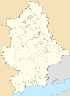
Lozove
Location of Lozove within Ukraine
Coordinates: 48°00′18″N37°38′38″E / 48.005°N 37.643889°E / 48.005; 37.643889 Coordinates: 48°00′18″N37°38′38″E / 48.005°N 37.643889°E / 48.005; 37.643889
Country Ukraine
Province Donetsk Oblast
District Yasynuvata Raion
Elevation 182 m (597 ft)
Population (2001 census)
  Total 366
Time zone EET (UTC+2)
  Summer (DST) EEST (UTC+3)
Postal code 83020
Area code +380 6236

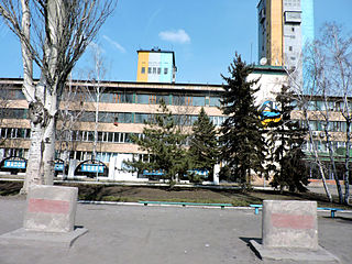
Lozove (Ukrainian : Лозове; Russian: Лозовое) is a rural settlement in Yasynuvata Raion (district) in Donetsk Oblast of eastern Ukraine, at 15 km W from the centre of Donetsk city.

Ukrainian language language member of the East Slavic subgroup of the Slavic languages

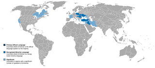
Ukrainian is an East Slavic language. It is the official state language of Ukraine, one of the three official languages in the unrecognized state of Transnistria, the other two being Romanian and Russian. Written Ukrainian uses a variant of the Cyrillic script.

Human settlement Community of any size, in which people live

In geography, statistics and archaeology, a settlement, locality or populated place is a community in which people live. The complexity of a settlement can range from a small number of dwellings grouped together to the largest of cities with surrounding urbanized areas. Settlements may include hamlets, villages, towns and cities. A settlement may have known historical properties such as the date or era in which it was first settled, or first settled by particular people.

Yasynuvata Raion Raion in Donetsk Oblast, Ukraine

Yasynuvata Raion is one of the 18 administrative raions of Donetsk Oblast, located in southeastern Ukraine. The administrative center of the district is the city of Yasynuvata, which is incorporated separately as a city of oblast significance and does not belong to the districts jurisdiction. Population: 27,845 (2013 est.)

The settlement was taken under control of pro-Russian forces during the War in Donbass, that started in 2014. [1]

War in Donbass armed conflict in the Donbass region of Ukraine

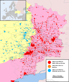
The War in Donbass is an armed conflict in the Donbass region of Ukraine. From the beginning of March 2014, protests by pro-Russian and anti-government groups took place in the Donetsk and Luhansk oblasts of Ukraine, commonly collectively called the "Donbass", in the aftermath of the 2014 Ukrainian revolution and the Euromaidan movement. These demonstrations, which followed the annexation of Crimea by the Russian Federation, and which were part of a wider group of concurrent pro-Russian protests across southern and eastern Ukraine, escalated into an armed conflict between the separatist forces of the self-declared Donetsk and Luhansk People's Republics, and the Ukrainian government. In the Donetsk People's Republic, from May 2014 until a change of the top leadership in August 2014, some of the top leaders were Russian citizens. According to the Ukrainian government, at the height of the conflict in mid-2014, Russian paramilitaries were reported to make up between 15% to 80% of the combatants.

Demographics

The settlement had 366 inhabitants in 2001. Native language as of the Ukrainian Census of 2001: [2]

The first Ukrainian census was carried out by State Statistics Committee of Ukraine on 5 December 2001, twelve years after the last Soviet Union census in 1989 and was so far the only census held in independent Ukraine. The total population recorded was 48,457,100 persons, of which the urban population was 32,574,500 (67.2%), rural: 15,882,600 (32.8%), male: 22,441,400 (46.3%), female: 26,015,700 (53.7%). The total permanent population recorded was 48,241,000 persons.

Bulgarian language South Slavic language

Bulgarian, is an Indo-European language and a member of the Southern branch of the Slavic language family.

Armenian language Indo-European language

The Armenian language is an Indo-European language spoken primarily by Armenians. It is the official language of Armenia. Historically being spoken throughout the Armenian Highlands, today, Armenian is widely spoken throughout the Armenian diaspora. Armenian is written in its own writing system, the Armenian alphabet, introduced in 405 AD by Mesrop Mashtots.

Related Research Articles

Donetsk Oblast Oblast in Ukraine

The Donetsk Oblast, also referred to as Donechyna, is an oblast (province) of eastern Ukraine. It is the most populated oblast, with around 4.5 million residents. Its administrative center is Donetsk; however, its Regional State Administration has been temporarily relocated to Kramatorsk because of the ongoing crisis in Donetsk. Historically, the region is an important part of the Donbas region. Until November 1961, it bore the name Stalino Oblast as Donetsk was then named "Stalino", in honour of Joseph Stalin. As part of the De-Stalinization process, it was renamed as its administrative center after Siversky Donets, the main artery of East Ukraine.

Donetsk City of regional significance in Donetsk Oblast, Ukraine

Donetsk is an industrial city in Ukraine on the Kalmius River. The population was estimated at 929,063 (2016 est.) in the city, and over 2,000,000 in the metropolitan area (2011). According to the 2001 Ukrainian Census, Donetsk was the fifth-largest city in Ukraine.

Makiivka Place in Donetsk Oblast, Ukraine

Makiivka or Makeyevka is an industrial city located in eastern Ukraine within the Donetsk Oblast (province), 15 kilometers (9.3 mi) from the capital Donetsk. Administratively, it is incorporated as a city of oblast significance. Its population is approximately 347,376 (2017 est.).

Kramatorsk City in Donetsk Oblast, Ukraine

Kramatorsk is a city of oblast significance located at the northern portion of Donetsk Oblast, in eastern Ukraine. Since October 11, 2014 Kramatorsk has been the provisional seat of Donetsk Oblast, following the events surrounding the War in Donbass.

Amvrosiivka Raion Raion in Donetsk Oblast, Ukraine

The Amvrosiivka Raion is a raion (district) within the eastern part of Donetsk Oblast in the Eastern Ukraine. The administrative center of the raion is the town of Amvrosiivka. Its population is approximately 44,379 (2017 est.).

Amvrosiivka Place in Donetsk, Ukraine

Amvrosiivka is a city and the administrative center of the Amvrosiivka Raion within Donetsk Oblast (province), Ukraine. Its population is approximately 18,413 (2017 est.).

Pokrovsk Raion Raion in Donetsk Oblast, Ukraine

Pokrovsk Raion, formerly Krasnoarmiisk Raion is a raion (district) within Donetsk Oblast in eastern Ukraine. Its administrative center is Pokrovsk, which is incorporated separately as a city of oblast significance and does not belong to the raion. Its area is 1,316 km2 (508 sq mi) and its population is approximately 30,653 (2017 est.).

Myrnohrad City in Donetsk, Ukraine

Myrnohrad, formerly Dymytrov, is a city of oblast significance in Donetsk Oblast (province) of Ukraine. Population: 49,646 (2013 est.).

Avdiivka City in Donetsk Oblast, Ukraine

Avdiivka is a city of oblast significance in Donetsk Oblast (province) of Ukraine. The city is located in center of the region just north from the city of Donetsk. Avdiivka is best known for its big Avdiivka Coke Plant. Officially the town's population is 35,128 (2013 est.); in January 2017 BBC News estimated that the population ranged between 16,000 and 22,000.

Kostiantynivka Raion Raion in Donetsk Oblast, Ukraine

Kostiantynivka Raion is one of the 18 administrative raions of Donetsk Oblast in eastern Ukraine. It covers approximately 4.4 percent of the oblast's total area. Population: 19,160 (2013 est.); 21,132.

Marinka Raion Raion in Donetsk Oblast, Ukraine

Marinka Raion is a raion (district) of Donetsk Oblast (province) located in eastern Ukraine. Its administrative center is the city of Marinka. Population: 84,317 (2013 est.).

Starobesheve Raion Raion in Donetsk Oblast, Ukraine

Starobesheve Raion is one of the 33 raions of Donetsk Oblast, located in southeastern Ukraine. The administrative center of the raion is the urban-type settlement of Starobesheve. Population: 50,675 (2013 est.).

Stanytsia Luhanska Urban-type settlement in Luhansk Oblast, Ukraine

Stanytsia Luhanska is an urban-type settlement on the banks of the Seversky Donets River in Luhansk Oblast in eastern Ukraine. Population: 13,734 (2013 est.). Stanytsia Luhanska is one of two local foundations of the Don Cossacks in today's Ukraine and the administrative center of the Stanytsia-Luhanska Raion 20 km northeast of Luhansk.

Vuhlehirsk City in Donetsk Oblast, Ukraine

Vuhlehirsk is a city in Bakhmut Raion, Donetsk Oblast (province) of Ukraine. The city's population was 10,309 in 2001. More recently, the population has been estimated to be 7,868 (2013 est.).

Svitlodarsk

Svitlodarsk is a city of district significance within the larger Debaltseve municipality, Donetsk Oblast (province) of Ukraine. Population: 12,164 (2013 est.).

Shyroka Balka Place in Donetsk Oblast, Ukraine

Shyroka Balka is a settlement in Horlivka municipality of Donetsk Oblast of eastern Ukraine, at 43.5 km NNE from the centre of Donetsk city.

Talakivka Urban-type settlement in Donetsk Oblast, Ukraine

Talakivka is an urban-type settlement in Kalmius Raion of Mariupol city in Donetsk Oblast of eastern Ukraine, at 89.4 km SSW from the centre of Donetsk city, at a distance of 19 km north from the centre of Mariupol, on the right bank of the Kalmius river. Population: 4,081 (2016 est.).

Ozeryanivka Place in Donetsk Oblast, Ukraine

Ozeryanivka is a settlement in Horlivka municipality of Donetsk Oblast of eastern Ukraine, at 41.8 km NNE from the centre of Donetsk city.

Bezimenne, Novoazovsk Raion Village in Donetsk Oblast, Ukraine

Bezimenne is a village in Novoazovsk Raion (district) in Donetsk Oblast of eastern Ukraine, at 133 km SSE from the centre of Donetsk city, on the shore of the Sea of Azov.

Holmivskyi Urban-type settlement in Donetsk Oblast, Ukraine

Holmivskyi is an urban-type settlement in Horlivka municipality of Donetsk Oblast of eastern Ukraine, at 50.9 km NNE from the centre of Donetsk city.

References