
Bomdila is the headquarters of West Kameng district in the state of Arunachal Pradesh in India. Bomdila is one of the 60 constituencies of the state of Arunachal Pradesh.

Aalo, formerly Along, is a census town and headquarter of the West Siang district district of the Indian state of Arunachal Pradesh. It is located 137 kilometres (85 mi) from Likabali, which is at the border of Assam and Arunachal Pradesh.
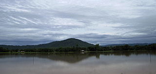
Diphu (Pron:ˈdɪfu:) is the headquarter of Karbi Anglong district in the state of Assam in India. This small town is a popular tourist hill station for people of nearby cities.
Haflong is a town and headquarters of Dima Hasao district in the state of Assam in India. It is the only hill station in Assam.

Barpeta is a town in Barpeta district of the state of Assam in India and is district headquarters. The city is located 90 kilometres (56 mi) north west of Guwahati and is one of the major cities in Western Assam. It is also called Satra Nagari of Assam due to the presence of various Vaishnavite Satras in the vicinity.

Morigaon is a town of town area committee and the district headquarters of Morigaon district in the Indian state of Assam and including the headquarters of the Tiwa Autonomous Council (TAC), Tiwashong, Assam which was constituted by the Government of Assam on 14 April 1995, The Apex council will consist of 144 villages of Nagaon, Morigaon and Kamrup with 28 blocks. Pincode of Morigaon town is 782105.
Kokrajhar is a town in the Bodoland Territorial Region, an autonomous territory in Assam, one of the North Eastern states of India.
Barpathar is a town and a municipality board in Golaghat district in the state of Assam, India.
Bokajan is a town in Karbi Anglong district in the state of Assam, India. Bokajan is best known for its Cement factory. It is 15 km away from Dimapur and partially borders Nagaland.
Dhekiajuli is a town and a municipal board in Sonitpur district in the state of Assam, India.
Golokganj is a census town in Dhubri district in the Indian state of Assam. Golakganj is one of the historical places of Dhubri district.
Jagiroad is a town in the state of Assam. Jagiroad located in Mayong Sub-Division, in Morigaon district. It is situated on the south bank of Kolong river.
Mariani is a neighbourhood town of Jorhat. It is about 17.5 km from Jorhat Town railway station. Mariani is in the border of Nagaland. Mariani is famous for the Gibbon Wildlife Sanctuary which is located on the roadside on the way to Nakachari from Mariani at a distance of 5 km. Pincode of Mariani is 785634.
Moranhat is a town and a town area committee in Charaideo district in the Indian state of Assam.The town is divided by N.H 37 into Charaideo and DibrugarH district.
New Bongaigaon Railway Colony is a census town in Bongaigaon district in the Indian state of Assam.

North Lakhimpur is a city and a municipal board in Lakhimpur district in the Indian state of Assam, about 394 kilometres (245 mi) northeast of Guwahati. It is the district headquarters of Lakhimpur district.
Rangapara is a town and a municipal board in Sonitpur district in the Indian state of Assam.

Silapathar is a city in Dhemaji district in the Indian state of Assam. The city is on the northern bank of the Brahmaputra River and is 470 kilometres (290 mi) from the city of Guwahati and just six km (3.7 mi) from border of Arunachal Pradesh. The longest rail cum road bridge in India connects Silapathar to Dibrugarh. Historical Malinithan mandir is located around ten km (6.2 mi) from Silapathar.
Lanka is a town located in Hojai District of Assam, and a town area committee with 11 wards. It serves as a trade and commerce hub for nearby areas such as Udali, Nokhuti, Laskar Pather, Karikhana, Kheroni, Dablong, and Doiyong sides. It is connected to other cities/states such as Guwahati by NH27.
Mahur is a town and a town area committee in Dima Hasao district in the Indian state of Assam.




 India
India 