Lutong

Last updated
Lutong
Town
Miri 25 November 2023 07.jpg
Grace Methodist Church
Malaysia location map.svg
Red pog.svg
Lutong
Location within Malaysia
Coordinates: 4°28′20″N114°00′39″E / 4.47229°N 114.01086°E / 4.47229; 114.01086
Country Malaysia
State Sarawak
Division Miri
District Miri
Time zone UTC+8 (MYT)
Postcode
98100, 98107, 98109


Lutong is a suburban township in Miri, a city in the state of Sarawak in Malaysia. An oil refinery was built in Lutong by Shell Oil Company. Lutong's economy is generated mainly from staff of the oil and gas companies located nearby. [1]

Contents

History

Australian soldiers inspecting a damaged oil refinery in 1945 Australian troops look at the damaged oil refinery installations, near Miri..JPG
Australian soldiers inspecting a damaged oil refinery in 1945

On 23 June 1945, the Australian Army landed and took control of the oil refinery and airstrip in three hours, with little resistance from the 553rd Independent Infantry Battalion. It was thought that a week earlier, the Japanese garrison had left the region and moved 6 kilometres (3.7 mi) to the southwest of Lutong, toward Miri. With the capture of Lutong, the Australians have gained control over the entire west coast of Borneo, extending our reach 80 miles (130 km) below Brooketon on the tip of the Brunei, where they landed just 12 days ago. They have also cut off the enormously valuable oilfield of Seria and placed the Australians across the main Japanese line of retreat down the coast. [2]

The key to the main oil fields on the west coast was Lutong. After being processed there, the oil from Seria was sent via sea lines to ships. The Japanese made every effort to further the development of Seria, which has the potential to be the largest field in the British Empire. They also made great efforts to maintain the Lutong refinery, which employed over 200 Indian POWs and an unknown number of Javanese as forced labor. [3] Huge quantities of machinery and other equipment were also brought by them. The refinery had been completely destroyed by intense Allied bombing for several months, and the airstrip on which they landed had also been abandonment by the Japanese a few months prior, when the Australians burst into Lutong on Wednesday morning. [2]

Allied bombs had damaged the hangar and the huts, but the field had fared better than the Labuan or Brunei strips, and it could be restored fast and simply. When the Australians arrived at Lutong, 135 Indian POWs, including Sikhs and Punjabis, were released. They were taken prisoner upon Singapore's collapse and sent to Lutong to labor in the refineries. They displayed symptoms of semi-starvation, maltreatment, and neglect spanning three years. and several were discovered by their patrols within the compound, so frail they were unable to leave. [2]

Transportation

RAAF Taylorcraft Auster at Lutong airstrip in July 1945 RAAF AUSTER SPOTTING AIRCRAFT (AWM 111365).jpg
RAAF Taylorcraft Auster at Lutong airstrip in July 1945

Road

Drivers who wish to avoid the excessive traffic on the main routes have taken to using Lutong Beach Road. Additionally, and sporadically, vehicles on this route from Lutong to Miri across the Piasau bridge have a nice glimpse of the sea. It used to be the sole path that connected Brunei with Miri. The beach was more resilient to the weight of the cars that were traveling through it to get to both locations back then. [4] In 2021, emergency construction to construct a 185 metres (607 ft) gabion wall was initiated as a temporary solution to prevent waves from Lutong Beach each from further damaging the coastline road near the Lutong Old Airport. [5]

Water

In the Second World War, soldiers and equipment were transported over rivers using jetties equipped with ferries (operated by the 2/13th Battalion). [6] [7] A Westland Hovercraft was seen skimming onto Lutong Beach. [8] Since there were no concrete roads, the only way to go from Lutong to Kuala Belait was to take boats across the Baram and Belait rivers and utilise the sandy beach. [9]

Air

Lutong Airstrip is a remnant of the Japanese occupation of World War II, with them operating Nakajima Ki-43s on the airstrip. [10] It was repeatedly bombed by allied forces during the Japanese occupation. It was later captured by the Australians to allow reconnaissance aircraft such as the Taylorcraft Austers, to land. [11] After being restored and put into service in 1954, when Malayan Airways expanded its Borneo service air network, the airstrip began to receive commercial passenger planes. This continued until the runway at Miri Airport was constructed. [12]

Infrastructure

Royal Dutch Shell constructed the first oil refinery in Sarawak in Tanjung Lobang, and then relocated it to Lutong. West Lutong discharged its first extract of foreign oil in 1968. [13] The first refinery in Malaysia, Shell's Lutong Refinery, received MS-ISO 9002-1991 certification from SIRIM in 1993. In 1996, the Lutong Refinery became the second refinery in shell and the first in Malaysia to hold the record of holding no lost time injuries after ten years. The Lutong Refinery in Miri was shut down in June 2003, having been in operation since 1917 and having gone 17 years without a license to operate. [14]

Religion

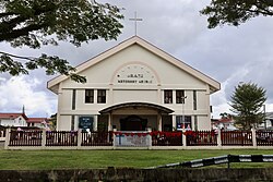
Grace Methodist Church is a large membership organisation that is a component of the SCAC (Sarawak Chinese Annual Conference) under the General Conference of the Malaysian Methodist Church. [15] [16] Another church, Good Shepherd Church Lutong, also sits within in the area. [17]

Places of interest

Lutong Beach is a beachfront located in front of the former Lutong Airfield. A botched effort at building a breakwater resulted in the numerous concrete pillars that protrude chaotically from the shorelines along the beach front. [18] Piasau is a short drive away, and the beach is reachable from the roadside. [8] Having been frequently battered by powerful waves in 2022, the beach started to show signs of wear and tear. Sea debris and logs that were carried ashore by heavy waves at high tide during the previous several days are all over the beach and the adjacent regions, including the roadways. [19]

See also

Related Research Articles

<span class="mw-page-title-main">Belait District</span> District of Brunei

Belait District, or simply Belait, is the largest as well as the westernmost district in Brunei. It has an area of 2,727 square kilometres (1,053 sq mi) and the population of 69,062 as of 2016. The administrative town is Kuala Belait, located at the mouth of the Belait River. The district is commonly associated with the oil and gas industry of the country, mainly concentrated near the town of Seria.

<span class="mw-page-title-main">Miri</span> Coastal city in north-eastern Sarawak, Malaysia

Miri is a coastal city in north-eastern Sarawak, Malaysia, located near the border of Brunei, on the island of Borneo. The city covers an area of 997.43 square kilometres (385.11 sq mi), located 798 kilometres (496 mi) north-east of Kuching and 329 kilometres (204 mi) south-west of Kota Kinabalu. Miri is the second-largest city in Sarawak, with a population of 356,900 as of 2020. The city is also the capital of Miri District, Miri Division.

<span class="mw-page-title-main">Brunei revolt</span> December 1962 insurrection in the British protectorate of Brunei

The Brunei revolt or the Brunei rebellion of 1962 was a December 1962 insurrection in the British protectorate of Brunei by opponents of its monarchy and its proposed inclusion in the Federation of Malaysia who wanted to establish a republic. The insurgents were members of the TNKU, a militia supplied by Indonesia and linked to the left-wing Brunei People's Party (BPP), which favoured a North Borneo Federation. The TNKU began co-ordinated attacks on the oil town of Seria, on police stations, and on government facilities around the protectorate. The revolt began to break down within hours, having failed to achieve key objectives such as the capture of Brunei Town and Sultan Omar Ali Saifuddien III. The revolt influenced the Sultan's 1963 decision not to join Malaysia. It is seen as one of the first stages of the Indonesia–Malaysia confrontation.

<span class="mw-page-title-main">Kuala Belait</span> Town in Brunei

Kuala Belait is the administrative town of Belait District, Brunei. The population of the town proper was 4,259 in 2016. Kuala Belait is officially a municipal area, as well as a village under the mukim of the same name. The town is located 85 kilometres (53 mi) west of the country's capital Bandar Seri Begawan, and 20 kilometres (12 mi) west of Seria, the district's other town. It is also in the westernmost part of country, near the mouth of the Belait River.

<span class="mw-page-title-main">Seria</span> Town in Brunei

Seria is a town in Belait District, Brunei, about 65 kilometres (40 mi) west from the country's capital Bandar Seri Begawan. The total population was 3,625 in 2016. It was where oil was first struck in Brunei in 1929 and has since become a centre for the country's oil and gas industry. The town's bazaar, officially opened on 19th September 1954, has few retail establishments, fresh food markets, supermarkets, banking services, tourist information centers, and a range of restaurants, including Malay, Chinese, Indian, Indonesian and Italian ones as well as outdoor dining in somewhat rustic settings. For processing documentation related to owning a car and hiring domestic helpers (amahs), government offices are located in Kuala Belait.

<span class="mw-page-title-main">Battle of Borneo (1941–1942)</span> WWII battle between Japanese and Dutch and British forces

The Battle of Borneo was a successful campaign by Japanese Imperial forces for control of Borneo island and concentrated mainly on the subjugation of the Raj of Sarawak, Brunei, North Borneo, and the western part of Kalimantan that was part of the Dutch East Indies. The Japanese main unit for this mission was the 35th Infantry Brigade led by Major General Kiyotake Kawaguchi.

<span class="mw-page-title-main">Bintulu</span> Town and district capital in Sarawak, Malaysia

Bintulu is a coastal town on the island of Borneo in the central region of Sarawak, Malaysia. Bintulu is located 610 kilometres northeast of Kuching, 216 kilometres northeast of Sibu, and 200 kilometres southwest of Miri. With a population of 114,058 as of 2010, Bintulu is the capital of the Bintulu District of the Bintulu Division of Sarawak, Malaysia.

<span class="mw-page-title-main">Marudi</span> Town in Sarawak

Marudi is a town in the Malaysian state of Sarawak, and is a part of the division of Miri. It is the seat of Marudi District, and is located on the banks of Baram River, about 100 kilometres (62 mi) upstream from the river mouth. Marudi was the administrative centre of the northern region of Sarawak before Miri was established in 1910. Marudi is considered as the cultural heart of the Orang Ulu, the highland tribes of Sarawak. It is also a transit gateway to Kelabit Highlands and Gunung Mulu National Park, a UNESCO World Heritage Site.

<span class="mw-page-title-main">Kampong Sungai Teraban</span> Village in Brunei

Kampong Sungai Teraban is a village in Belait District, Brunei, near the district's principal town Kuala Belait. It has an area of 22 square kilometres (8.5 sq mi); the population was 1,082 in 2016. It is one of the administrative villages within Mukim Kuala Belait.

<span class="mw-page-title-main">Mukim Kuala Belait</span> Mukim of Brunei

Mukim Kuala Belait is a mukim in Belait District, Brunei. The population was 31,308 in 2016. The mukim encompasses Kuala Belait, the administrative town of the district.

<span class="mw-page-title-main">Rasau</span> Onshore oil field in Brunei

Rasau is an area in Brunei. The area contains one of the two oil fields of Brunei, the Rasau Field, and a small village, Kampong Rasau, which has a population of 103.

<span class="mw-page-title-main">Sungai Tujoh</span> Border checkpoint between Brunei and Malaysia

Sungai Tujoh, is the westernmost point of Brunei. It is located in the Belait district.

<span class="mw-page-title-main">Mukim Labi</span> Mukim of Brunei

Mukim Labi is a mukim in the interior of Belait District, Brunei. It has an area of 361.8 square kilometres (139.7 sq mi); the population was 1,216 in 2016.

The Diocese of Kuching is a diocese of the Anglican Church of the Province of South East Asia that covers Sarawak and Brunei. Founded in 1962, the see was originally established as the Bishopric of Sarawak linked to the Diocese of Labuan in 1855. The current bishop is the Most Rev'd Danald Jute, 14th Lord Bishop of the Diocese of Kuching and Brunei, who was consecrated on 13 August 2017. His seat is at St. Thomas' Cathedral, Kuching.

<span class="mw-page-title-main">G. S. Carter</span> Australian Army officer

Major Gordon Senior 'Toby' Carter DSO was a New Zealand surveyor and road engineer who worked in Sarawak, Borneo prior to World War II for Shell Oil. He enlisted with the British Army during the war, and served in the Royal Australian Engineers and later in Z Special Unit in Borneo, where he was the Officer in Command of the Semut II operation in the Kelabit Highlands of Sarawak. In 1962 Carter had the initial idea for and was the driving force behind the establishment of both the Kinabalu National Park and the Kundasang War Memorial and Gardens near Mount Kinabalu in Sabah.

<span class="mw-page-title-main">Bekenu</span> Place in Sarawak, Malaysia

Bekenu is a small fishing town near Miri, in Sarawak, Malaysia. Bekenu bazaar is the capital of the Sibuti subdistrict, Subis district, Miri Division.

Lutong Airport(IATA: LUT, ICAO: WMLU) was an airport serving Lutong, a satellite town north of Miri, Sarawak, Malaysia. The airstrip used to belong to Royal Dutch Shell. It was opened during World War II and renovated in 1954, and it continued to operate until the inauguration of the new Miri Airport during the 1980s. The airport was decommissioned in the early 2000s and its terminal and hangars have been demolished, with only the landing strip preserved. The strip was used for racing until the deteriorating condition of the strip rendered it unsuitable for car drag racing.

<span class="mw-page-title-main">Seria oil field</span> Onshore oil field in Brunei

Seria oil field also known as Seria Field is the largest oil field in northwest Borneo, discovered in 1929. The oil is accumulated in Upper Miocene sandstone, trapped in Seria Anticline that straddles the present day coastline. This field has produced more than 1 billion barrels of oil for more than 75 years. Brunei Shell Petroleum (BSP) is the operator of this field.

<span class="mw-page-title-main">Transport in Brunei</span>

Transport in Brunei consists of air, land, and sea transport. Previously there was some rail transport in Brunei, but eventually most of it was closed down. Several public and commercial sector organizations are in charge of creating and overseeing these networks and infrastructures. The Ministry of Transport and Infocommunications (MTIC) is in charge of overseeing the maritime and aviation industries, as well as planning and regulating all kinds of land transportation.

<span class="mw-page-title-main">Kampong Kuala Tutong</span> Village in Tutong District

Kampong Kuala Tutong, also simply known as Kuala Tutong, is a village in Tutong District, Brunei, within the mukim of Pekan Tutong. The postcode for Kampong Kuala Tutong is TA3341.

References

  1. "Lutong".
  2. 1 2 3 "AUSTRALIANS TAKE LUTONG, KEY SARAWAK OIL REFINERY CENTRE". Examiner. 1945-06-23. Retrieved 2024-01-07.
  3. "Lutong oil refinery". www.awm.gov.au. Retrieved 2024-01-07.
  4. "Lutong Beach Road bears brunt of erosion and storms". Borneo Post Online. 2021-01-10. Retrieved 2024-01-07.
  5. "The Official Portal of the Sarawak Government". sarawak.gov.my. Retrieved 2024-01-07.
  6. "LUTONG AREA, BORNEO, 4 JULY 1945. THE MIRI RIVER FERRY WITH A 3 TON TRUCK OF 2/13 INFANTRY ..." www.awm.gov.au. Retrieved 2024-01-07.
  7. "LUTONG AREA, BORNEO. 22 JUNE 1945. MEMBERS OF 2/13 INFANTRY BATTALION RUNNING THE FERRY SERVICE ..." www.awm.gov.au. Retrieved 2024-01-07.
  8. 1 2 "Lutong Beach". Miri, Sarawak. 2015-06-20. Retrieved 2024-01-07.
  9. "###**Journey From Miri to Kuala Belait". Memories of The Way We Were. 2014-11-03. Retrieved 2024-01-07.
  10. "LUTONG, BORNEO. 1945-08-28. A WRECKED JAPANESE NAKAJIMA KI-43 OSCAR AIRCRAFT ON THE EDGE OF THE ..." www.awm.gov.au. Retrieved 2024-01-07.
  11. "LUTONG AREA, BORNEO, 4 JULY 1945. AN RAAF AUSTER SPOTTING AIRCRAFT LANDING ON THE SMALL AIRSTRIP ..." www.awm.gov.au. Retrieved 2024-01-07.
  12. "Lutong Airstrip (Decommissioned)". Miri, Sarawak. 2015-05-28. Retrieved 2024-01-07.
  13. "Sejarah perjalanan Sarawak dalam industri minyak dan gas". www.utusanborneo.com.my (in Malay). 2018-03-08. Retrieved 2024-01-07.
  14. "Shell Malaysia Upstream History | Shell Malaysia". www.shell.com.my. Retrieved 2024-01-07.
  15. "Grace Methodist Church". Church.com.my. 2015-10-28. Retrieved 2024-01-07.
  16. "Sarawakiana@2: Grace Methodist Christmas Church Service and Christmas Lunch". Sarawakiana@2. 2009-12-25. Retrieved 2024-01-07.
  17. "Good Shepherd Church Lutong continues tradition of Christmas open house". Borneo Post Online. 2023-01-08. Retrieved 2024-01-07.
  18. "The Miri Lutong Beach". The Miri Lutong Beach. Retrieved 2024-01-07.
  19. editorJY (2022-07-14). "Lutong Beach battered by 7-metre high waves, covered in debris". DayakDaily. Retrieved 2024-01-07.