Related Research Articles

Sclerophyll is a type of vegetation that is adapted to long periods of dryness and heat. The plants feature hard leaves, short internodes and leaf orientation which is parallel or oblique to direct sunlight. The word comes from the Greek sklēros (hard) and phyllon (leaf). The term was coined by A.F.W. Schimper in 1898, originally as a synonym of xeromorph, but the two words were later differentiated.

Tropical and subtropical moist broadleaf forests (TSMF), also known as tropical moist forest, is a subtropical and tropical forest habitat type defined by the World Wide Fund for Nature.

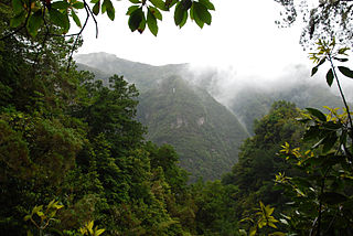
The Queensland tropical rain forests ecoregion covers a portion of the coast of Queensland in northeastern Australia and belongs to the Australasian realm. The forest contains the world's best living record of the major stages in the evolutionary history of the world's land plants, including most of the world's relict species of plants from the ancient supercontinent of Gondwana. The history of the evolution of marsupials and songbirds is also well represented.
Carolina bays are elliptical to circular depressions concentrated along the East Coast of the United States within coastal New York, New Jersey, Delaware, Maryland, Virginia, North Carolina, South Carolina, Georgia, and north Florida. In Maryland, they are called Maryland basins. Within the Delmarva Peninsula, they and other coastal ponds are also called Delmarva bays.

The Last Glacial Period (LGP), also known colloquially as the Last Ice Age or simply Ice Age, occurred from the end of the Eemian to the end of the Younger Dryas, encompassing the period c. 115,000 – c. 11,700 years ago.

Sundaland is a biogeographical region of South-eastern Asia corresponding to a larger landmass that was exposed throughout the last 2.6 million years during periods when sea levels were lower. It includes Bali, Borneo, Java, and Sumatra in Indonesia, and their surrounding small islands, as well as the Malay Peninsula on the Asian mainland.

The Last Glacial Maximum (LGM), also referred to as the Last Glacial Coldest Period, was the most recent time during the Last Glacial Period that ice sheets were at their greatest extent 26,000 and 20,000 years ago. Ice sheets covered much of Northern North America, Northern Europe, and Asia and profoundly affected Earth's climate by causing a major expansion of deserts, along with a large drop in sea levels.
Laurel forest, also called laurisilva or laurissilva, is a type of subtropical forest found in areas with high humidity and relatively stable, mild temperatures. The forest is characterized by broadleaf tree species with evergreen, glossy and elongated leaves, known as "laurophyll" or "lauroid". Plants from the laurel family (Lauraceae) may or may not be present, depending on the location.

Marine isotope stages (MIS), marine oxygen-isotope stages, or oxygen isotope stages (OIS), are alternating warm and cool periods in the Earth's paleoclimate, deduced from oxygen isotope data derived from deep sea core samples. Working backwards from the present, which is MIS 1 in the scale, stages with even numbers have high levels of oxygen-18 and represent cold glacial periods, while the odd-numbered stages are lows in the oxygen-18 figures, representing warm interglacial intervals. The data are derived from pollen and foraminifera (plankton) remains in drilled marine sediment cores, sapropels, and other data that reflect historic climate; these are called proxies.
Amino acid dating is a dating technique used to estimate the age of a specimen in paleobiology, molecular paleontology, archaeology, forensic science, taphonomy, sedimentary geology and other fields. This technique relates changes in amino acid molecules to the time elapsed since they were formed.

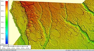
Lake Euramoo is a shallow dumbbell-shaped volcanic crater lake in Danbulla, Tablelands Region, Far North Queensland, Australia. It was formed about 23,000 years ago by two massive explosions from groundwater superheating.

The flora of Australia comprises a vast assemblage of plant species estimated to over 21,000 vascular and 14,000 non-vascular plants, 250,000 species of fungi and over 3,000 lichens. The flora has strong affinities with the flora of Gondwana, and below the family level has a highly endemic angiosperm flora whose diversity was shaped by the effects of continental drift and climate change since the Cretaceous. Prominent features of the Australian flora are adaptations to aridity and fire which include scleromorphy and serotiny. These adaptations are common in species from the large and well-known families Proteaceae (Banksia), Myrtaceae, and Fabaceae.

Reclus, also written as Reclús, is a volcano located in the Southern Patagonian Ice Field, Chile. Part of the Austral Volcanic Zone of the Andes, its summit rises 1,000 metres (3,300 ft) above sea level and is capped by a crater about 1 kilometre (0.62 mi) wide. Close to the volcano lies the Amalia Glacier, which is actively eroding Reclus.

Burraga Swamp is situated beside Mount Lumeah in the Barrington Tops area in New South Wales, Australia. It is surrounded by Antarctic beech cool temperate rainforest at an altitude of 985 metres above sea level.
Tasmania can be broadly divided into two distinct regions, eastern and western, that exhibit major differences in climate, geology and vegetation. This divide, termed Tyler’s Corridor, runs from just south of the northwestern corner, and continues south, cutting roughly down the center of the island. The vegetation changes occur principally due to variations in soil types, which are a result of the geological composition, and the vast difference in climate across the state. Generally, the west has a higher mean rainfall but poor acidic soil while the east has a lower mean rainfall but slightly more fertile soil. This results in a larger proportion of rainforest, moorland and wet sclerophyll vegetation dominating in the west and predominantly dry sclerophyll in the east.

Ciomadul is a dormant volcano in Romania. It is in the Eastern Carpathians, between the spa towns of Băile Tușnad and Balvanyos. Ciomadul lies at the southeastern end of the Carpathian volcanic chain and it is the youngest volcano of the Carpatho-Pannonian region. Ciomadul consists of several lava domes with two embedded explosion craters known as Mohoș and Sfânta Ana, the latter of which contains a crater lake, Lake Sfânta Ana. The dominant volcanic rock at Ciomadul is potassium-rich dacite.

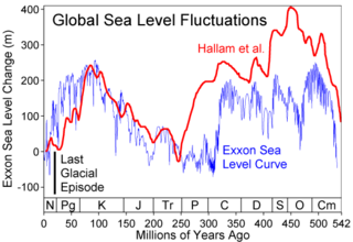
The Penultimate Glacial Period (PGP) is the glacial age that occurred before the Last Glacial Period. The penultimate glacial period is officially unnamed just like the Last Glacial Period. While the PGP is a part of the ongoing Quaternary ice age, which began 2.58 million years ago, the PGP lasted from ~194,000 years ago, to ~135,000 years ago. The PGP also occurred during the Marine Isotope age 6 (MIS6). At the glacial ages’ height, it is known to be the most extensive expansion of glaciers in the last 400,000 years over Eurasia, and could be the second or third coolest glacial period over the last 1,000,000 years, as shown by ice cores. Due to this, the global sea level dropped to between 92 and 150 metres below modern-day global mean sea level. The penultimate glacial period expanded ice sheets and shifted temperature zones worldwide, which had a variety of effects on the world's environment, and the organisms that lived in it. At its height, the penultimate glacial period was a more severe glaciation than the Last Glacial Maximum. The PGP is an unofficial name for the last period of the Saalian glaciation, called the Wolstonian Stage in Britain.
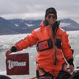
Julie Brigham-Grette is a glacial geologist and a professor in the Department of Geosciences at the University of Massachusetts Amherst where she co-directs the Joseph Hartshorn Quaternary Laboratory. Her research expertise is in glacial geology and paleoclimatology; she has made important contributions to Arctic marine and terrestrial paleoclimate records of late Cenozoic to recent, the evolution of the Arctic climate, especially in the Beringia/Bering Strait region, and was a leader of the international Lake El’gygytgyn Drilling Project in northeastern Russia.
Kinrara is a volcano in Queensland, Australia. It is one of the youngest volcanoes in Australia, and erupted 7,000 years ago.
Paleohydrology, or palaeohydrology, is the scientific study of the movement, distribution, and quality of water on Earth during previous periods of its history. The discipline uses indirect evidence to infer changes in deposition rates, the existence of flooding, changes in sea levels, changes in groundwater levels and the erosion of rocks. It also deals with alterations in the floral and faunal assemblages which have come about in previous periods because of changes in hydrology.
References
- ↑ Rieser, Uwe; Wüst, Raphael A.J. (2010). "OSL chronology of Lynch's Crater, the longest terrestrial record in NE-Australia". Quaternary Geochronology. 5 (2–3): 233–236. doi:10.1016/j.quageo.2009.05.014.
- 1 2 Rieser, Uwe; Wüst, Raphael A. J. (April–June 2010), "OSL chronology of Lynch's Crater, the longest terrestrial record in NE-Australia", Quaternary Geochronology, 5 (2–3): 233–236, doi:10.1016/j.quageo.2009.05.014.
- 1 2 Kershaw, A. P. (1976), "A Late Pleistocene and Holocene Pollen Diagram from Lynch's Crater, North-Eastern Queensland, Australia", New Phytologist, 77 (2): 469–498, doi: 10.1111/j.1469-8137.1976.tb01534.x , JSTOR 2433618.
- ↑ Russell-Smith, Jeremy; Stanton, Peter (2002), "Fire regimes and fire management of rainforest communities", in Bradstock, Ross Andrew; Williams, Jann Elizabeth; Gill, Arthur Malcolm (eds.), Flammable Australia: The Fire Regimes and Biodiverstiy of a Continent, Cambridge University Press, p. 333, ISBN 0521805910.