Sedimentary rocks are types of rock that are formed by the accumulation or deposition of mineral or organic particles at Earth's surface, followed by cementation. Sedimentation is the collective name for processes that cause these particles to settle in place. The particles that form a sedimentary rock are called sediment, and may be composed of geological detritus (minerals) or biological detritus. The geological detritus originated from weathering and erosion of existing rocks, or from the solidification of molten lava blobs erupted by volcanoes. The geological detritus is transported to the place of deposition by water, wind, ice or mass movement, which are called agents of denudation. Biological detritus was formed by bodies and parts of dead aquatic organisms, as well as their fecal mass, suspended in water and slowly piling up on the floor of water bodies. Sedimentation may also occur as dissolved minerals precipitate from water solution.

Orogeny is a mountain-building process that takes place at a convergent plate margin when plate motion compresses the margin. An orogenic belt or orogen develops as the compressed plate crumples and is uplifted to form one or more mountain ranges. This involves a series of geological processes collectively called orogenesis. These include both structural deformation of existing continental crust and the creation of new continental crust through volcanism. Magma rising in the orogen carries less dense material upwards while leaving more dense material behind, resulting in compositional differentiation of Earth's lithosphere. A synorogenic process or event is one that occurs during an orogeny.

A braided river consists of a network of river channels separated by small, often temporary, islands called braid bars or, in British English usage, aits or eyots.

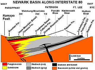
Sedimentary basins are region-scale depressions of the Earth's crust where subsidence has occurred and a thick sequence of sediments have accumulated to form a large three-dimensional body of sedimentary rock. They form when long-term subsidence creates a regional depression that provides accommodation space for accumulation of sediments. Over millions or tens or hundreds of millions of years the deposition of sediment, primarily gravity-driven transportation of water-borne eroded material, acts to fill the depression. As the sediments are buried, they are subject to increasing pressure and begin the processes of compaction and lithification that transform them into sedimentary rock.

An alluvial fan is an accumulation of sediments that fans outwards from a concentrated source of sediments, such as a narrow canyon emerging from an escarpment. They are characteristic of mountainous terrain in arid to semiarid climates, but are also found in more humid environments subject to intense rainfall and in areas of modern glaciation. They range in area from less than 1 square kilometer (0.4 sq mi) to almost 20,000 square kilometers (7,700 sq mi).

In geology, a rift is a linear zone where the lithosphere is being pulled apart and is an example of extensional tectonics. Typical rift features are a central linear downfaulted depression, called a graben, or more commonly a half-graben with normal faulting and rift-flank uplifts mainly on one side. Where rifts remain above sea level they form a rift valley, which may be filled by water forming a rift lake. The axis of the rift area may contain volcanic rocks, and active volcanism is a part of many, but not all, active rift systems.
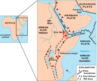
The East African Rift (EAR) or East African Rift System (EARS) is an active continental rift zone in East Africa. The EAR began developing around the onset of the Miocene, 22–25 million years ago. It was formerly considered to be part of a larger Great Rift Valley that extended north to Asia Minor.

The West Antarctic Rift System is a series of rift valleys between East and West Antarctica. It encompasses the Ross Embayment, the Ross Sea, the area under the Ross Ice Shelf and a part of Marie Byrd Land in West Antarctica, reaching to the base of the Antarctic Peninsula. It has an estimated length of 3,000 km (1,900 mi) and a width of approximately 700 km (430 mi). Its evolution is due to lithospheric thinning of an area of Antarctica that resulted in the demarcation of East and West Antarctica. The scale and evolution of the rift system has been compared to that of the Basin and Range Province of the Western United States.

A back-arc basin is a type of geologic basin, found at some convergent plate boundaries. Presently all back-arc basins are submarine features associated with island arcs and subduction zones, with many found in the western Pacific Ocean. Most of them result from tensional forces, caused by a process known as oceanic trench rollback, where a subduction zone moves towards the subducting plate. Back-arc basins were initially an unexpected phenomenon in plate tectonics, as convergent boundaries were expected to universally be zones of compression. However, in 1970, Dan Karig published a model of back-arc basins consistent with plate tectonics.

The Andean orogeny is an ongoing process of orogeny that began in the Early Jurassic and is responsible for the rise of the Andes mountains. The orogeny is driven by a reactivation of a long-lived subduction system along the western margin of South America. On a continental scale the Cretaceous and Oligocene were periods of re-arrangements in the orogeny. The details of the orogeny vary depending on the segment and the geological period considered.

The geology of Russia, the world's largest country, which extends over much of northern Eurasia, consists of several stable cratons and sedimentary platforms bounded by orogenic (mountain) belts.
Tectonic subsidence is the sinking of the Earth's crust on a large scale, relative to crustal-scale features or the geoid. The movement of crustal plates and accommodation spaces produced by faulting brought about subsidence on a large scale in a variety of environments, including passive margins, aulacogens, fore-arc basins, foreland basins, intercontinental basins and pull-apart basins. Three mechanisms are common in the tectonic environments in which subsidence occurs: extension, cooling and loading.
A half-graben is a geological structure bounded by a fault along one side of its boundaries, unlike a full graben where a depressed block of land is bordered by parallel faults.

Provenance in geology, is the reconstruction of the origin of sediments. The Earth is a dynamic planet, and all rocks are subject to transition between the three main rock types: sedimentary, metamorphic, and igneous rocks. Rocks exposed to the surface are eventually broken down into sediments. Sediments are expected to be able to provide evidence of the erosional history of their parent source rocks. The purpose of provenance study is to restore the tectonic, paleo-geographic and paleo-climatic history.

The North Sea is part of the Atlantic Ocean in northern Europe. It is located between Norway and Denmark in the east, Scotland and England in the west, Germany, the Netherlands, Belgium and France in the south.
The Angola Basin is located along the West African South Atlantic Margin which extends from Cameroon to Angola. It is characterized as a passive margin that began spreading in the south and then continued upwards throughout the basin. This basin formed during the initial breakup of the supercontinent Pangaea during the early Cretaceous, creating the Atlantic Ocean and causing the formation of the Angola, Cape, and Argentine basins. It is often separated into two units: the Lower Congo Basin, which lies in the northern region and the Kwanza Basin which is in the southern part of the Angola margin. The Angola Basin is famous for its "Aptian Salt Basins," a thick layer of evaporites that has influenced topography of the basin since its deposition and acts as an important petroleum reservoir.

The Kutai sedimentary basin extends from the central highlands of Borneo, across the eastern coast of the island and into the Makassar Strait. With an area of 60,000 km2, and depths up to 15 km, the Kutai is the largest and deepest Tertiary age basin in Indonesia. Plate tectonic evolution in the Indonesian region of SE Asia has produced a diverse array of basins in the Cenozoic. The Kutai is an extensional basin in a general foreland setting. Its geologic evolution begins in the mid Eocene and involves phases of extension and rifting, thermal sag, and isostatic subsidence. Rapid, high volume, sedimentation related to uplift and inversion began in the Early Miocene. The different stages of Kutai basin evolution can be roughly correlated to regional and local tectonic events. It is also likely that regional climate, namely the onset of the equatorial ever wet monsoon in early Miocene, has affected the geologic evolution of Borneo and the Kutai basin through the present day. Basin fill is ongoing in the lower Kutai basin, as the modern Mahakam River delta progrades east across the continental shelf of Borneo.
River incision is the narrow erosion caused by a river or stream that is far from its base level. River incision is common after tectonic uplift of the landscape. Incision by multiple rivers result in a dissected landscape, for example a dissected plateau. River incision is the natural process by which a river cuts downward into its bed, deepening the active channel. Though it is a natural process, it can be accelerated rapidly by human factors including land use changes such as timber harvest, mining, agriculture, and road and dam construction. The rate of incision is a function of basal shear-stress. Shear stress is increased by factors such as sediment in the water, which increase its density. Shear stress is proportional to water mass, gravity, and WSS:

The Junggar Basin, also known as the Dzungarian Basin or Zungarian Basin, is one of the largest sedimentary basins in Northwest China. It is located in Dzungaria in northern Xinjiang, and enclosed by the Tarbagatai Mountains of Kazakhstan in the northwest, the Altai Mountains of Mongolia in the northeast, and the Heavenly Mountains in the south. The geology of Junggar Basin mainly consists of sedimentary rocks underlain by igneous and metamorphic basement rocks. The basement of the basin was largely formed during the development of the Pangea supercontinent during complex tectonic events from Precambrian to late Paleozoic time. The basin developed as a series of foreland basins – in other words, basins developing immediately in front of growing mountain ranges – from Permian time to the Quaternary period. The basin's preserved sedimentary records show that the climate during the Mesozoic era was marked by a transition from humid to arid conditions as monsoonal climatic effects waned. The Junggar basin is rich in geological resources due to effects of volcanism and sedimentary deposition. According to Guinness World Records it is a land location remotest from open sea with great-circle distance of 2,648 km from the nearest open sea at 46°16′8″N86°40′2″E.
Fluvial seismology is the application of seismological methods to understand river processes, such as discharge, erosion, and streambed evolution. Flowing water and the movement of sediments along the streambed generate elastic (seismic) waves that propagate into the surrounding Earth materials. Seismometers can record these signals, which can be analyzed to illuminate different fluvial processes such as turbulent water flow and bedload transport. Seismic methods have been used to observe discharge values that range from single-digits up through tens of thousands of cubic feet per second (cfs).