Sizergh Castle is a stately home with garden and estate at Helsington in Cumbria, England, about 4 miles (6 km) south of Kendal. Located in historic Westmorland, the castle is a Grade I listed building. While remaining the home of the Hornyold-Strickland family, the castle with its garden and estate is in the care of the National Trust.
Alfred Wainwright MBE, who preferred to be known as A. Wainwright or A.W., was a British fellwalker, guidebook author and illustrator. His seven-volume Pictorial Guide to the Lakeland Fells, published between 1955 and 1966 and consisting entirely of reproductions of his manuscript, has become the standard reference work to 214 of the fells of the English Lake District. Among his 40-odd other books is the first guide to the Coast to Coast Walk, a 182-mile (293-kilometre) long-distance footpath devised by Wainwright which remains popular today.

The River Huntspill is an artificial river, in the Somerset Levels, in the Sedgemoor district of Somerset, England. It was built in 1940 to supply process water to ROF Bridgwater, and has resulted in reduced flooding of the lower Brue Valley. Huntspill Sluice at the river's western end, also known as West Huntspill Sluice, separates it from the River Parrett.

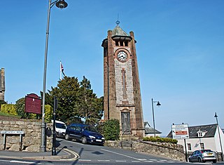
Grange-over-Sands is a town and civil parish on the north side of Morecambe Bay in Cumbria, England, a few miles south of the Lake District National Park. In the 2011 census the parish had a population of 4,114, increasing at the 2021 census to 4,279. Within the boundaries of the historic county of Lancashire, the town became administered as an urban district in 1894. Though the town remains part of the Duchy of Lancaster, since 2023 it has been administered as part of the Westmorland and Furness Council area.

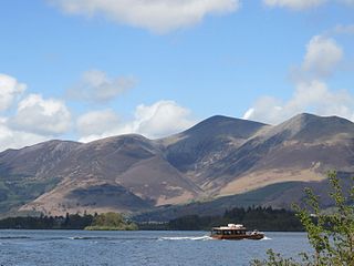
Skiddaw is a mountain in the Lake District National Park in England. Its 931-metre (3,054 ft) summit is traditionally considered to be the fourth-highest peak but depending on what topographic prominence is thought to be significant is also variously ranked as the third- and the sixth-highest in England. It lies just north of the town of Keswick, Cumbria, and dominates the skyline in this part of the northern lakes. It is the simplest of the Lake District mountains of this height to ascend and, as such, many walking guides recommend it to the occasional walker wishing to climb a mountain. This is the first summit of the fell running challenge known as the Bob Graham Round when undertaken in a clockwise direction.

Bassenthwaite Lake is a body of water in the Lake District in North West England, near the town of Keswick. It has an area of 5.3 km2 (2.0 sq mi), making the fourth largest of the lakes in the region. The lake has a length of approximately 4 miles (6.4 km) long and maximum width of 0.75 miles (1 km), a maximum depth of 19 m (62 ft), and a surface elevation of 68 m (223 ft) above sea level. Its primary inflow and outflow is the River Derwent, which drains into the Irish Sea at Workington. The lake is in the unitary authority of Cumberland, and the ceremonial county of Cumbria.

Haweswater is a reservoir in the valley of Mardale, Cumbria in the Lake District, England. Work to raise the height of the original natural lake was started in 1929. It was controversially dammed after the UK Parliament passed a Private Act giving Manchester Corporation permission to build the reservoir to supply drinking water to the city. The decision caused a public outcry because the farming villages of Measand and Mardale Green would be flooded and the valley altered forever.

Whitbarrow is a hill in Cumbria, England, designated a biological Site of Special Scientific Interest and national nature reserve, forming part of the Morecambe Bay Pavements Special Area of Conservation due to its supporting some of the best European examples of natural limestone habitats. Also known as Whitbarrow Scar, the hill lies about 9 kilometres (5.6 mi) southwest of Kendal, just north of the A590 road, close to the village of Witherslack. Part of the site is a local nature reserve called Whitbarrow Scar. Whitbarrow's summit, known as Lord's Seat, is at 215 metres (705 ft) and has a prominence of 182 metres (597 ft), classifying it as a Marilyn.

Westmorland and Lonsdale is a constituency in the south of Cumbria, represented in the House of Commons of the UK Parliament since 2005 by Tim Farron, the former leader of the Liberal Democrats (2015–2017).
The 2004 South Lakeland District Council election took place on 10 June 2004 to elect members of South Lakeland District Council in Cumbria, England. One third of the council was up for election and the council stayed under no overall control.
Mardale is a glacial valley in the Lake District, in northern England. The valley used to have a hamlet at its head, called Mardale Green, but this village was submerged in the late 1930s when the water level of the valley's lake, Haweswater, was raised to form Haweswater Reservoir by Manchester Corporation.

Seathwaite is a small hamlet in the Borrowdale civil parish of Cumberland, Cumbria, North West England. It is in the Lake District near Scafell Pike and 8 miles (13 km) southwest of Keswick at the end of a minor road that heads southwest from the hamlet of Seatoller, which is where the B5289 road begins its steep climb up the pass to Honister Hause on the boundary between Borrowdale civil parish and Buttermere civil parish.

Cartmel Fell is a hamlet and a civil parish in the South Lakeland district of Cumbria, England. In the 2001 census the parish had a population of 309, increasing at the 2011 census to 329. The village of Cartmel and Cartmel Priory are not in this parish but in Lower Allithwaite, to the south: Cartmel Fell church is about 7 miles north of Cartmel Priory.

The Bannisdale Horseshoe is an upland area in Cumbria, England, near the eastern boundary of the Lake District National Park, surrounding the valley of Bannisdale Beck, a tributary of the River Mint. It is described in the final chapter of Wainwright's book The Outlying Fells of Lakeland.

Hesk Fell is a hill in the south-west of the English Lake District, between the Duddon Valley and Eskdale near Ulpha, Cumbria. It is the subject of a chapter of Wainwright's book The Outlying Fells of Lakeland. It reaches 1,566 feet (477 m) and Wainwright's route, an anticlockwise circuit from the Birker Fell road, also visits The Pike at 1,214 feet (370 m). Wainwright admits that the fell "has many shortcomings" and that the view of Scafell Pike and its neighbours is "the only reward for the ascent".

Stainton Pike is a hill in the English Lake District, near Waberthwaite, Cumbria. It is the subject of a chapter of Wainwright's book The Outlying Fells of Lakeland. It reaches 1,550 feet (470 m) and Wainwright's anticlockwise circuit also visits The Knott at 1,071 feet (326 m). The walk also passes the waterfall Rowantree Force and collection of ancient enclosures and hut circles known as Barnscar or City of Barnscar.

Scout Scar, also called Underbarrow Scar, is a hill in the English Lake District, west of Kendal, Cumbria and above the village of Underbarrow. It reaches 771 feet (235 m). Scout Scar is the subject of a chapter of Wainwright's book The Outlying Fells of Lakeland, but the summit he describes is a lower summit at 764 feet (233 m), 270m south of the highest point. Wainwright's anticlockwise recommended route also includes Cunswick Scar at 679 feet (207 m). The higher summit of Scout Scar has a topographic prominence of 109m and is thus classified as a HuMP, a hill with a prominence of at least 100m.

The Wasdale Horseshoe is a group of hills on the eastern fringe of the English Lake District, to the west of the A6, south of Shap, Cumbria. They surround the valley of Wasdale Beck, a tributary of Birk Beck and ultimately of the River Lune. The horseshoe is the subject of a chapter of Wainwright's book The Outlying Fells of Lakeland. This Wasdale should not be confused with the better known Wasdale, containing Wast Water, on the west of the Lake District.

Hugill Fell is a hill in the English Lake District, near Staveley, Cumbria, on the western side of the Kentmere valley.

Knipescar Common, or Knipe Scar, is an upland area in the east of the English Lake District, above the River Lowther, near Bampton, Cumbria. It is the subject of a chapter of Wainwright's book The Outlying Fells of Lakeland. The summit is "indefinite" but reaches 1,118 feet (341 m) and there are limestone outcrops and an ancient enclosure. Wainwright commends the views which include Blencathra to the north and "a continuous skyline of the higher Pennines."


