
Westmorland is a historic county in north-west England. It formed an administrative county between 1889 and 1974, after which the whole county was administered by the new administrative county of Cumbria. In 2013, the Secretary of State for Communities and Local Government, Eric Pickles, formally recognised and acknowledged the continued existence of England's 39 historic counties, including Westmorland.

Cumberland is a historic county of North West England that had an administrative function from the 12th century until 1974. It is bordered by the historic counties of Northumberland to the northeast, County Durham to the east, Westmorland to the southeast, Lancashire to the south, and the Scottish counties of Dumfriesshire and Roxburghshire to the north. It formed an administrative county from 1889 to 1974 and now forms part of Cumbria.

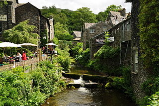
Kirkby Lonsdale is a town and civil parish in the South Lakeland district of Cumbria, England, on the River Lune. Historically in Westmorland, it lies 13 miles (21 km) south-east of Kendal on the A65. The parish recorded a population of 1,771 in the 2001 census, increasing to 1,843 at the 2011 Census. Notable buildings include St Mary's Church, a Norman building with fine carved columns. The view of the River Lune from the churchyard is known as Ruskin's View after John Ruskin, who called it one of the loveliest in England. It was painted by J. M. W. Turner.

Skiddaw is a mountain in the Lake District National Park in England. Its 931-metre (3,054 ft) summit is the sixth-highest in England. It lies just north of the town of Keswick, Cumbria, and dominates the skyline in this part of the northern lakes. It is the simplest of the Lake District mountains of this height to ascend and, as such, many walking guides recommend it to the occasional walker wishing to climb a mountain. This is the first summit of the fell running challenge known as the Bob Graham Round when undertaken in a clockwise direction.

The Brathay is a river of north-west England. Its name comes from Old Norse and means broad river. It rises at a point 1289 feet above sea level near the Three Shire Stone at the highest point of Wrynose Pass in the Lake District. Its catchment area includes the northern flanks of Wetherlam, Great Carrs and others of the Furness Fells, as well as a substantial area of the Langdale Fells.

The Rothay is a spate river of the Lake District in north-west England. Its name comes from Old Norse and translates literally as the red one. This has come to mean trout river. It rises close to Rough Crag above Dunmail Raise at a point about 1542 feet above sea level. Its catchment area covers Grasmere Common including Easedale Tarn, the southern flanks of Fairfield, and several of the fells to the east of Dunmail Raise, including Great Rigg, Rydal Fell, Scandale Fell and Heron Pike.

Westmorland and Lonsdale is a constituency in the south of Cumbria, represented in the House of Commons of the UK Parliament since 2005 by Tim Farron, the former leader of the Liberal Democrats (2015–2017).

The Trout Beck is a fast flowing stream of the Lake District in North West England. It is one of the main sources of replenishment for Windermere, and is part of the Leven catchment. Its name comes from Old Norse and appears in documents from 1292 as Trutebyk. The river rises between the peaks of Stony Cove Pike and Thornthwaite Crag in the High Street range, at a height of about 1,970 feet.

Blennerhasset and Torpenhow is a civil parish in the Allerdale district of Cumbria, England. According to the 2001 census it had a population of 437, reducing to 423 at the 2011 Census. It includes the villages of Blennerhasset grid reference NY178415 and Torpenhow at NY202397 and the smaller settlement of Kirkland Guards at NY187401. It is located just outside the Lake District National Park. Baggrow railway station was immediately north of Blennerhasset.
The Barony of Westmorland also known as North Westmorland, the Barony of Appleby, Appleshire or the Bottom of Westmorland, was one of two baronies making up the English historical county of Westmorland, the other being the Barony of Kendal. Geographically, the barony covered the northern part of the larger county of the same name, and was divided into two wards – East Ward and West Ward. It covered an area similar to that of the Eden District of the new county of Cumbria, although it did not include Penrith, which is now the administrative capital of the district.

The Cumberland dialect is a local Northern English dialect in decline, spoken in Cumberland, Westmorland and surrounding northern England, not to be confused with the area's extinct Celtic language, Cumbric. Some parts of Cumbria have a more North-East English sound to them. Whilst clearly spoken with a Northern English accent, it shares much vocabulary with Scots. A Cumbrian Dictionary of Dialect, Tradition and Folklore by William Rollinson exists, as well as a more contemporary and lighthearted Cumbrian Dictionary and Phrase Book.

Kentmere is a valley, village and civil parish in the Lake District National Park, a few miles from Kendal in the South Lakeland district of Cumbria, England. Historically in Westmorland, at the 2011 census Kentmere had a population of 159.

The River Winster is a river in the English county of Cumbria. The Winster was the boundary between the ancient counties of Lancashire and Westmorland. It has a relatively small catchment area; other streams flow parallel to it on either side.

The River Pool is a river in the English county of Cumbria.

The River Belah is a river in the county of Cumbria in England. Its name derives from the Old English word Belge and means the "Roaring River".

Lodore Falls is a waterfall in Cumbria, England, close to Derwentwater and downstream from Watendlath. The falls are located on the beck that flows from Watendlath Tarn, and tumble more than 100 feet (30 m) over a steep cascade into the Borrowdale Valley. Although it is spectacular in the rainy season, it can dry to a trickle in the summer.

Stainmore is a remote geographic area in the Pennines on the border of Cumbria, County Durham and North Yorkshire. The name is used for a civil parish in the Eden District of Cumbria, England, including the villages of North Stainmore and South Stainmore. The parish had a population of 253 in the 2001 census, increasing to 264 at the Census 2011. Stainmore Forest stretches further east into County Durham, towards Bowes.

St Bees Priory is the parish church of St Bees, Cumbria, England. There is evidence for a pre-Norman religious site, and on this a Benedictine priory was founded by the first Norman Lord of Egremont William Meschin, and was dedicated by Archbishop Thurstan of York, sometime between 1120 and 1135.

Cliburn is a village and civil parish in the Eden district of Cumbria, England. The civil parish includes the hamlet of Town Head. In 2001 the population was 204, increasing to 274 at the 2011 Census.
Stock Ghyll, also known as Stock Gill, Stock Gill Beck and Stock Beck, is a stream in South Lakeland, in the ceremonial county of Cumbria and the historic county of Westmorland. It flows about four miles from Red Screes through the town of Ambleside to the River Rothay. Its course includes two long-popular tourist attractions, Stockghyll Force and Bridge House. Stock Ghyll has been painted by J. M. W. Turner, John Ruskin, Kurt Schwitters, and many others. Its name derives from Old English stocc, 'tree-trunk', and Old Norse gil, 'a deep glen'.
