
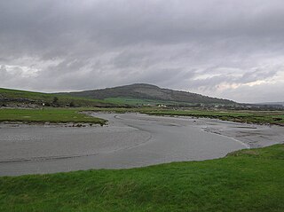
The River Irt is a river in the county of Cumbria in northern England. It flows for 14 miles (22 km) from the south-western end of Wast Water, the deepest lake in England, leaving the lake at the foot of Whin Rigg, the southern peak of the famous Wastwater Screes. The name of the river is believed to derive either from the Old English gyr which means "mud", or from the Brittonic words *ar, "flowing", or *īr, "fresh, clean, pure", suffixed with -ed, a nominal suffix meaning "having the quality of...".

The River Mint is a river in Cumbria, England. The Mint starts life at Whelpside at the confluence of Bannisdale Beck, running south-east from Bannisdale Head, and a smaller stream draining a group of small valleys from headwaters in The Forest, Combs Hollow and Mabbin Crag.

The River Gilpin is a river in the English county of Cumbria. Formerly, the river was in the county of Westmorland.
The River Keer is a river in Lancashire, England.

The River Eea is a small river in the Lake District, Cumbria, England running through the Furness region, which until 1974 was part of Lancashire. It is a relatively short system that arises from numerous small becks and streams throughout the Cartmel Valley. Its course is approximately 10 km long and its mouth is on Sand Gate marshes near Flookburgh, between Barrow and Kendal. It principally flows in a south-westerly direction.

The River Lyne is a river of Cumbria in England.

The River Marron is a river of Cumbria, England.

The River Calder is a river in Cumbria, England.
Leck Beck is a watercourse in Lancashire with its source on Crag Hill in Cumbria between Leck Fell and Casterton Fell.

Barbon Beck is a small river in Cumbria. It is a tributary of the River Lune.
Crosby Ravensworth is a village and civil parish in the Eden district of Cumbria, England. The village is about 4 miles (6.4 km) east of the M6 motorway, and Shap. At the 2001 census the parish had a population of 538, decreasing to 517 at the 2011 Census.

The Edward C. Waller Apartments are located from 2840 to 2858 W. Walnut Street in Chicago, Illinois. They were designed by Frank Lloyd Wright and built in 1895 and named after Edward C. Waller, a prominent Chicago developer after the 1871 fire. Waller and Wright collaborated on the Waller apartments and the Francisco Terrace apartments to execute Waller's pioneering idea of subsidizing lower income housing. Each apartment was designed with a parlor, chamber (bedroom), dining room, kitchen, bathroom, and closets.
The River Lune is a river in County Durham, England.
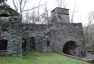
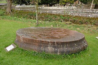
The Duddon furnace is a surviving charcoal-fueled blast furnace near Broughton-in-Furness in Cumbria. It is on the west side of the River Duddon in the parish of Millom and formerly in Cumberland.

The River Annas is a minor river in Cumbria in northwest England. It is formed as the Kinmont Beck and Crookley Beck which drain the southwestern fells of the Lake District, meet on the eastern edge of the village of Bootle. Their combined waters flow southwest towards Annaside on the Irish Sea coast. However longshore drift has diverted the river northwestwards parallel to the shore for a further 1.2 miles (2 km) so that it enters the sea at Selker. This section of river is followed by the Cumbria Coastal Way. The river is bridged by the A595 road and the Cumbrian coast railway line.

The Wasdale Horseshoe is a group of hills on the eastern fringe of the English Lake District, to the west of the A6, south of Shap, Cumbria. They surround the valley of Wasdale Beck, a tributary of Birk Beck and ultimately of the River Lune. The horseshoe is the subject of a chapter of Wainwright's book The Outlying Fells of Lakeland. This Wasdale should not be confused with the better known Wasdale, containing Wast Water, on the west of the Lake District.

Knipescar Common, or Knipe Scar, is an upland area in the east of the English Lake District, above the River Lowther, near Bampton, Cumbria. It is the subject of a chapter of Wainwright's book The Outlying Fells of Lakeland. The summit is "indefinite" but reaches 1,118 feet (341 m) and there are limestone outcrops and an ancient enclosure. Wainwright commends the views which include Blencathra to the north and "a continuous skyline of the higher Pennines."

The Limestone Link is a waymarked footpath in South Lakeland, Cumbria, England, connecting Arnside and Kirkby Lonsdale, a distance of 13 miles (21 km).

Mosedale Beck is a river in Cumbria, England, which rises on the northern slopes of Great Dodd and flows north east, to the south of Clough Head before joining the River Glenderamackin to the east of Threlkeld village. This then flows west, alongside the A66 road south of Blencathra, to form the River Greta which flows into the River Derwent.
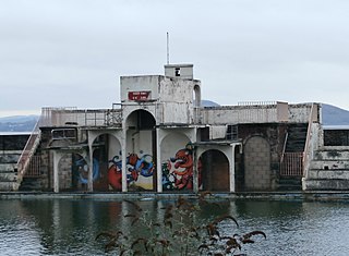
Grange Lido is an open-air 50 m sea-water swimming pool, or lido, in Grange-over-Sands, Cumbria, England. It opened in 1932 and closed in 1993, but campaigners are working to see it re-opened as a swimming pool. The lido is in Art Deco style, and is grade II listed.
