Palakkad District, in the southeastern part of the former Malabar district, is one of the 14 districts of the South Indian state of Kerala. It is located right at the central part of the state. Also, it is the largest district in Kerala since 2006. The city of Palakkad is the district headquarters. Palakkad is bordered on the northwest by the Malappuram District, on the southwest by the Thrissur District, on the northeast by Nilgiris District, and on the east by Coimbatore district of Tamil Nadu. The district is 24.4% urbanized according to the census of 2011.The district is nicknamed "the granary of Kerala". In 2006 the Ministry of Panchayati Raj named Palakkad one of the country's 250 most backward districts out of a total of 640.

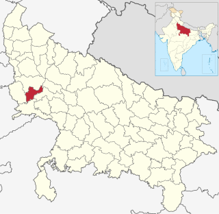
Hathras district is a district of Uttar Pradesh state of India. The city of Hathras is the district headquarters. Hathras district is a part of Aligarh division. The district occupies an area of 1,840 square kilometres (710 sq mi) and has a population of 1,564,708 as of the 2011 census.

Bargur is a selection-grade town panchayat in the Krishnagiri district of the Indian state of Tamil Nadu, that serves as the headquarters of Bargur taluk, one of the seven taluks in Krishnagiri district.

Killai is a second-grade panchayat town in the Chidambaram taluk of the Cuddalore district of Tamil Nadu, India.

Sironcha is a town and municipal council in Gadchiroli district of Maharashtra state in India. It connected with NH-63.

The Vellar River is river in the Indian state of Tamil Nadu. It originates in the Kalrayan Hills, and runs through Salem, Perambalur, and Cuddalore districts, before flowing into the Bay of Bengal near Parangipettai. The river has a total length of 150 kilometres (93 mi), and its drainage basin covers an area of 7,504.346 square kilometres (2,897.444 sq mi) in Cuddalore, Perambalur, Salem, Viluppuram, Ariyalur, Namakkal, Tiruchirappalli, and Dharmapuri districts.

Perinthalmanna is a town, a municipality, and the headquarters of the Perinthalmanna taluk in Malappuram district, Kerala, India. The town is located 23 kilometres (14 mi) south-west to the city of Malappuram and 24 kilometres (15 mi) away from Manjeri. It is one of the major commercial centers in the district, even though it doesn't form a part of the Malappuram metropolitan area. The town is home to several medical institutions. The town is home to one of the three off-centres of Aligarh Muslim University in India, which is popularly known as AMU Malappuram Campus. Kodikuthimala, one of the popular tourist destinations in the state, is also located here. The town was the headquarters of Valluvanad Taluk, which was one of the two Taluks included in Malappuram Revenue Division at the time, in the erstwhile Malabar District during British Raj.

Chak Guru is a village in Shaheed Bhagat Singh Nagar district of Punjab State, India. It is located 9.2 kilometres (5.7 mi) away from Garhshankar, 17.6 kilometres (10.9 mi) from Balachaur, 17 kilometres (11 mi) from district headquarter Shaheed Bhagat Singh Nagar and 87 kilometres (54 mi) from state capital Chandigarh. The village is administrated by Sarpanch an elected representative of the village.

Mirzapur is a village in the Shaheed Bhagat Singh Nagar district of Punjab State, India. It is located 3.3 kilometres (2.1 mi) from branch post office Kahlon, 15 kilometres (9.3 mi) from Nawanshahr, 16 kilometres (9.9 mi) from district headquarters Shaheed Bhagat Singh Nagar and 96 kilometres (60 mi) from state capital Chandigarh. The village is administrated by Sarpanch, an elected representative of the village.

Noklak is the youngest and the 12th district of Nagaland state in India, It was established on January 20, 2021. The district headquarter is in the town of Noklak.

Anchetty is a village in the Denkanikottai taluk of the Krishnagiri district of the Indian state of Tamil Nadu. The village is in the southern half of the taluk, and is the headquarters of one of its seven firkas.

Belur is a first-grade town panchayat in the Vazhapadi taluk of Salem district, in Tamil Nadu, India.

Masinaickenpatti is a census town in the Vazhapadi taluk of Salem district, in Tamil Nadu, India.

Doramangalam is a census town in the Mettur taluk of Salem district, in Tamil Nadu, India.

Kurichi is a village in the Vazhapadi taluk of Salem district, in Tamil Nadu, India.

Tukkiyampalayam is a village in the Vazhapadi taluk of Salem district, in Tamil Nadu, India.

Singipuram is a village in the Vazhapadi taluk of Salem district, in Tamil Nadu, India.

Tirumanur is a village in the Vazhapadi taluk of Salem district, in Tamil Nadu, India.

Vellalakundam is a village in the Vazhapadi taluk of Salem district, in Tamil Nadu, India.

Minnampalli is a village in the Vazhapadi taluk of Salem district, in Tamil Nadu, India.


