Bentley Systems, Incorporated is an American-based software development company that develops, manufactures, licenses, sells and supports computer software and services for the design, construction, and operation of infrastructure. The company's software serves the building, plant, civil, and geospatial markets in the areas of architecture, engineering, construction (AEC) and operations. Their software products are used to design, engineer, build, and operate large constructed assets such as roadways, railways, bridges, buildings, industrial plants, power plants, and utility networks. The company re-invests 20% of their revenues in research and development

WesternGeco is a geophysical services company. It is headquartered in the Schlumberger House on the property of London Gatwick Airport in Crawley, West Sussex, in Greater London.

Reflection seismology is a method of exploration geophysics that uses the principles of seismology to estimate the properties of the Earth's subsurface from reflected seismic waves. The method requires a controlled seismic source of energy, such as dynamite or Tovex blast, a specialized air gun or a seismic vibrator. Reflection seismology is similar to sonar and echolocation. This article is about surface seismic surveys; for vertical seismic profiles, see VSP.

Magnetotellurics (MT) is an electromagnetic geophysical method for inferring the earth's subsurface electrical conductivity from measurements of natural geomagnetic and geoelectric field variation at the Earth's surface.

The United Kingdom is one of the best locations for wind power in the world and is considered to be the best in Europe. By the beginning of November 2021, the UK had 11,018 wind turbines with a total installed capacity of over 24.3 gigawatts: 13.9 gigawatts of onshore capacity and 10.4 gigawatts of offshore capacity, the sixth largest capacity of any country in 2019. Wind power contributed 24.8% of UK electricity supplied in 2020, having surpassed coal in 2016 and nuclear in 2018. It is the largest source of renewable electricity in the UK. The UK Government has committed to a major expansion of offshore capacity by 2030.

CGG is a French-based geophysical services company founded in 1931.

NORSAR or Norwegian Seismic Array was established in 1968 as part of the Norwegian-US agreement for the detection of earthquakes and nuclear explosions.

The 1693 Sicily earthquake struck parts of southern Italy near Sicily, Calabria, and Malta on January 11 at around 21:00 local time. This earthquake was preceded by a damaging foreshock on January 9. The main quake had an estimated magnitude of 7.4 on the moment magnitude scale, the most powerful in Italian recorded history, and a maximum intensity of XI (Extreme) on the Mercalli intensity scale, destroying at least 70 towns and cities, seriously affecting an area of 5,600 square kilometres (2,200 sq mi) and causing the death of about 60,000 people.
ION Geophysical provides acquisition equipment, software, planning and seismic processing services, and seismic data libraries to the global oil & gas industry. The company's technologies and services are used by E&P operators and seismic acquisition contractors to generate high-resolution images of the subsurface during exploration, exploitation and production operations. Headquartered in Houston, Texas, ION has offices in the United States, Canada, Latin America, Europe, Africa, Russia, China and the Middle East.
NPA Satellite Mapping is the longest-established satellite mapping specialist in Europe, with expertise in geoscience applications of earth observation and remote sensing. In addition to processing and distributing data from a variety of optical and radar satellites, NPA specialises in added-value and derived products, providing validation and interpretation of satellite-based imagery.
Andrew S. Long is an Australian geophysicist. He has a PhD in geophysics (1996) from the University of Western Australia, and a post-doctoral term at Stanford University. He is a leader in the application of geophysical technologies to exploration for oil and gas in marine areas, and has written and presented several papers at the Society of Exploration Geophysicists (SEG), the European Association of Geoscientists and Engineers (EAGE), the Australian Society of Exploration Geophysicists (ASEG), the Australian Petroleum Production & Exploration Association (APPEA) and many other international conventions and journals.
This is a list of free and open-source software for geophysical data processing and interpretation. The list is split into broad categories, depending on the intended use of the software and its scope of functions.

RadExPro is a Windows-based seismic processing software system produced by DECO Geophysical Software Company. It is suitable for field QC of 3D and 2D marine and on-land seismic data, advanced processing of HR/UHR offshore seismic, as well as for the onshore near-surface seismic reflection, refraction, MASW, and VSP processing.
An ocean-bottom seismometer (OBS) is a seismometer that is designed to record the earth motion under oceans and lakes from man-made sources and natural sources.
Robert E. Sheriff was an American geophysicist best known for writing the comprehensive geophysical reference, Encyclopedic Dictionary of Exploration Geophysics. His main research interests included the seismic detailing of reservoirs, in 3-D seismic interpretation and seismic stratigraphy, and practical applications of geophysical methods. Hua-Wei Zhou, Department Chair of the Department of Earth and Atmospheric Sciences, said about Sheriff: “…a giant figure in the world of exploration geophysics… When I think about Bob, a number of key words pop up in my mind: kindness, honesty, hardworking, seeking perfection, generosity and wisdom.”

Seismic data acquisition is the first of the three distinct stages of seismic exploration, the other two being seismic data processing and seismic interpretation. Seismic acquisition requires the use of a seismic source at specified locations for a seismic survey, and the energy that travels within the subsurface as seismic waves generated by the source gets recorded at specified locations on the surface by what is known as receivers.

In early 1981 the eastern Gulf of Corinth, Greece was struck by three earthquakes with a magnitude greater than 6 over a period of 11 days. The earthquake sequence caused widespread damage in the Corinth–Athens area, destroying nearly 8,000 houses and causing 20–22 deaths.

Geological engineering is a discipline of engineering concerned with the application of geological science and engineering principles to fields such as civil engineering, mining, environmental engineering, and forestry, among others. The work of geological engineers often directs or supports the work of other engineering disciplines such as assessing the suitability of locations for civil engineering, environmental engineering, mining operations, and oil and gas projects by conducting geological, geoenvironmental, geophysical, and geotechnical studies. They are involved with impact studies for facilities and operations that affect surface and subsurface environments. The engineering design input and other recommendations made by geological engineers on these projects will often have a large impact on construction and operations. Geological engineers plan, design, and implement geotechnical, geological, geophysical, hydrogeological, and environmental data acquisition. This ranges from manual ground-based methods to deep drilling, to geochemical sampling, to advanced geophysical techniques and satellite surveying. Geological engineers are also concerned with the analysis of past and future ground behaviour, mapping at all scales, and ground characterization programs for specific engineering requirements. These analyses lead geological engineers to make recommendations and prepare reports which could have major effects on the foundations of construction, mining, and civil engineering projects. Some examples of projects include rock excavation, building foundation consolidation, pressure grouting, hydraulic channel erosion control, slope and fill stabilization, landslide risk assessment, groundwater monitoring, and assessment and remediation of contamination. In addition, geological engineers are included on design teams that develop solutions to surface hazards, groundwater remediation, underground and surface excavation projects, and resource management. Like mining engineers, geological engineers also conduct resource exploration campaigns, mine evaluation and feasibility assessments, and contribute to the ongoing efficiency, sustainability, and safety of active mining projects
The Sureste Basin or Salinas-Sureste Basin is a hydrocarbon province located in southeast Mexico. The basin covers an area of 188 000 km2 and comprises proven reserves of 50 billion barrels of oil. Due to recent successful explorations, the area has been called a Super Basin.
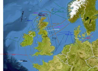
The British Institutions Reflection Profiling Syndicate, better known by its acronym BIRPS, was set up to acquire deep seismic reflection profiles around the United Kingdom Continental Shelf (UKCS). It was formed, initially as BURPS, the British Universities Reflection Profiling Syndicate, involving geophysicists from the Natural Environment Research Council (NERC) and British Universities. After the involvement of other institutions the name was changed to BIRPS and by February 1981 NERC had approved funding for a four-year programme. The next ten years saw the collection of 12,000 km of deep seismic profiles around the British Isles. By the time NERC stopped funding the program in 1997, more than 20,000 km of data had been acquired.