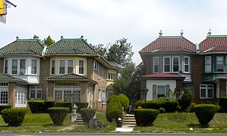
Lawncrest is a neighborhood in the "Near" (lower) Northeast Philadelphia, Pennsylvania. The name is an amalgam of Lawndale and Crescentville, the two primary communities that make up the neighborhood. The Philadelphia Inquirer does not consider Lawncrest to be a neighborhood.

Center City includes the central business district and central neighborhoods of Philadelphia, Pennsylvania, United States. It comprises the area that made up the City of Philadelphia prior to the Act of Consolidation, 1854, which extended the city borders to be coterminous with Philadelphia County.

Kensington is a neighborhood in Philadelphia that belongs to Lower Northeast. As with all neighborhoods in the city, the lack of any official designation means the boundaries of the area vary between sources over time and are disputed among locals. Kensington, as most long-term residents view it, refers generally to the area consisting of Kensington, East Kensington, West Kensington, and Harrowgate. The adjacent Fairhill and Norris Square neighborhoods are more separate but may be included in Kensington; Fishtown and South (Olde) Kensington were historically included. The most conservative boundaries of the neighborhood, shown in the map below, are Front Street and 5th Street to the west, the Amtrak train tracks to the North, Trenton Avenue, the Trenton Avenue train tracks, and Frankford Avenue to the east, and Cecil B. Moore Avenue to the south.

North Philadelphia, nicknamed North Philly, is a section of Philadelphia, Pennsylvania. It is immediately north of Center City. Though the full extent of the region is somewhat vague, "North Philadelphia" is regarded as everything north of either Vine Street or Spring Garden Street, between Northwest Philadelphia and Northeast Philadelphia. It is bordered to the north by Olney Ave along Broad Street, Spring Garden Street to the south, 35th Street to the west and Adams Avenue to the east. The Philadelphia Police Department patrols five districts located within North Philadelphia: the 22nd, 25th, 26th, 35th and 39th districts. There are thirteen ZIP codes for North Philadelphia: 19120, 19121, 19122, 19123, 19125, 19126, 19130, 19132, 19133, 19134, 19137, 19140 and 19141.

The Cradle of Liberty Council (#525) is a Boy Scouts of America council created in 1996 with the merger of the former Philadelphia Council and the former Valley Forge Council.
Cobbs Creek is a neighborhood located in the West Philadelphia section of Philadelphia, Pennsylvania, United States, named for the creek which forms part of Philadelphia's western border. Cobbs Creek is generally bounded by Market Street to the north, Baltimore Avenue to the south, 52nd Street to the east, and the border of Upper Darby along Cobbs Creek to the West.
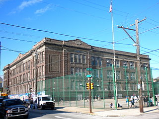
Benjamin Franklin High School is a public high school located in Philadelphia, Pennsylvania. The school, located north of Center City, is a part of the School District of Philadelphia. Franklin serves sections of North Philadelphia and Center City.

The Philadelphia Fire Department provides fire protection and emergency medical services (EMS) to the city of Philadelphia. The PFD's official mission is to protect public safety by quick and professional response to emergencies and through the promotion of sound emergency prevention measures. This mandate encompasses all traditional firefighting functions, including fire suppression, with 58 Engine companies and 27 Ladder companies as well as specialty and support units deployed throughout the city; specialized firefighting units for Philadelphia International Airport and the Port of Philadelphia; investigations conducted by the Fire Marshal's Office to determine the origins of fires and to develop preventive strategies; prevention programs to educate the public in order to increase overall fire safety; and support services such as: research and planning, management of the Fire Communications Center within the City's 911 system, and operation of the Fire Academy.
The Historical Society of Frankford is a historical society and museum is a 501(c)3 corporation located in Philadelphia, Pennsylvania. It is located in the Frankford neighborhood of Northeast Philadelphia. It was a founding member of the Pennsylvania Federation of Historical Societies.
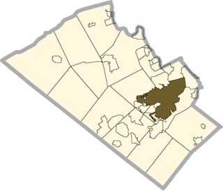
The Allentown School District is a large, urban public school district located in Allentown, Pennsylvania in the Lehigh Valley region of eastern Pennsylvania. The district is the fourth-largest school district in Pennsylvania as of the 2016-17 academic year.
Whitman is a neighborhood in the South Philadelphia section of Philadelphia, Pennsylvania, United States. It is bounded on the west by Sixth Street, on the east by Front Street, on the south by Bigler Street, and on the north by Snyder Avenue. The name "Whitman" was adopted when the nearby Walt Whitman Bridge was being constructed in the 1950s. In 2015, Whitman and nearby South Philadelphia neighborhoods were named by Philadelphia Magazine as one of the safest and most family-friendly neighborhoods in Philadelphia.
Hope Charter School is a free, public high school available to all 9th through 12th grade students. Hope Charter School is located in the West Oak Lane section of Philadelphia, Pennsylvania.

The Pennsylvania School for the Deaf is the third-oldest school of its kind in the United States. Its founder, David G. Seixas (1788–1864), was a Philadelphia crockery maker-dealer who became concerned with the plight of impoverished deaf children who he observed on the city's streets. The current school building is listed by the National Register of Historic Places, and two former campuses are similarly recognized.

The Center for Architecture and Design is a 501(c)(3) non-profit organization located in Philadelphia, Pennsylvania. The Center produces educational programs related to the topics of architecture, urban planning, and design, including talks, workshops, festivals, design competitions, and exhibitions. Their venue at 1218 Arch Street serves as a public forum as well as a home for the offices of the Center, for AIA Philadelphia, and for the Community Design Collaborative. The organization was founded in 2002 by the Philadelphia chapter of the American Institute of Architects (AIA).

Maurice H. Kornberg School of Dentistry is the dental school of Temple University, located in Philadelphia, Pennsylvania, United States. It is one of several dental schools in the state of Pennsylvania. The average incoming class is 140 students.

Center City Allentown is the downtown and central business district of Allentown, Pennsylvania, the third largest city in the U.S. state of Pennsylvania. It has a dense population and is currently undergoing an urban revitalization process.

Education in and around the neighborhood of Harlem, in Manhattan, New York City, is provided in schools and institutions of higher education, both public and private. For many decades, Harlem has had a lower quality of public education than wealthier sections of the city. It is mostly lower-income.
William L. Sayre High School is a high school in Philadelphia and a part of the School District of Philadelphia. It was founded in 1949 as a middle school serving grades 7–9, becoming a high school in 2003. Sayre High School is also the home site of SHIELD, a Sayre Health Center run enrichment program providing medical assistant training, health professions education, internship employment and scholarship opportunities for School District of Philadelphia high school students.

Universal Audenried Charter High School , formerly Charles Y. Audenried High School, is a high school servicing the Grays Ferry area of Philadelphia. The school was originally located at the Charles Y. Audenried Junior High School but was rebuilt in 2008. It was previously directly operated by the School District of Philadelphia. It is still a part of the district's system, and some South Philadelphia residences are assigned to Audenried.
The Samual S Fels High School is a district-run high school in Philadelphia. The school is named after Samuel Simeon Fels. It was founded in 1989 when the Samuel S. Fels Junior High School was restructured to have seventh through tenth grades, with the eleventh and twelfth grades to be added in 1990 and 1991. Melvin K. McMaster was the first principal of the high school. An $80 million building replaced the old facility in 2009.
